Location listing filters
Map for Accessible Cycling
Note for screen reader users, we suggest skip the following interactive map and go to the location listing for a better user experience.
Currently, the map is not accessible yet for a comprehensive experience.
skip to the location listing
Location Listing
Showing 1 - 8 of 9 results for Accessible Cycling Locations
-
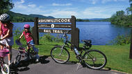
Ashuwillticook Rail Trail
- Wheelchair Accessible
Ashuwillticook Rail Trail, Cheshire, MA 01225 DirectionsThe Ashuwillticook Rail Trail is an old railroad track converted into a 10-foot wide paved trail. The trail runs 12.7 miles through the towns of Cheshire, Lanesborough and Adams. Cheshire Reservoir, and the Hoosic River offer outstanding views of the scenery and wildlife. Parking lots and restrooms are available at selected locations along the way.Phone(413) 499-7003-
Dawn to dusk
-
Blackstone River and Canal Heritage State Park
- Wheelchair Accessible
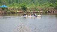
287 Oak St. , Uxbridge, MA 01569 DirectionsThe Blackstone River features 1000 acres of natural park, filled with trails and historical sites. The park also has biking, horseback riding, canoe access, fishing, hunting, picnic areas and more.
The story of River Bend Farm in Uxbridge, MA serves as an example of the story of many farms in the Blackstone Valley. Located about half way between Providence, Rhode Island and Worcester, Massachusetts, River Bend Farm sits at the crossroads of agricultural life, mill villages, transportation routes, and developing town centers. River Bend Farm represents the changing landscape over the last four centuries.
There are fields, open pastures, stone walls, and preserved historical sites that bear witness to a farming past in a valley that witnessed the birth of an industrial revolution.
River Bend Farm today stands as a reminder of the Valley’s long agrarian past. Indeed, glimpses of the Valley’s heritage are evident throughout the region. The landscape tells the story of how everyday life changed with succeeding generations – and how it continues to change today.Phone(508) 278-7604-
Sunrise to sunset
-

Bradley Palmer State Park
- Wheelchair Accessible
40 Asbury St, Topsfield, MA 01983 DirectionsThis former estate features 721-acres of pine needled paths and sunny rolling meadows for hiking, biking, and horseback riding.Phone(978) 887-5931-
Sunrise to sunset
-
Canalside Rail Trail
- Wheelchair Accessible
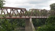
2 Avenue A, Turners Falls, MA 01376 DirectionsThe Canalside Rail Trail follows the former rail bed for an easy-riding 3.7 miles. Follow the trail over the Connecticut River and along scenic views. The trail is also great for walking or even a picnic.Phone(413) 863-3221-
Sunrise to sunset
-
Cape Cod Rail Trail
- Wheelchair Accessible
3488 Main St., Brewster, MA 02631 DirectionsRide, walk or run through 6 Cape Cod towns as you follow the Cape Cod Rail Trail. There’s plenty to see along the 25-mile trail and state and national parks to visit as you please.Phone(508) 896-3491-
Sunrise to sunset
-
Lower Neponset River Trail
- Wheelchair Accessible
Hallet Street, Boston, MA 02124 DirectionsThis rail trail spans 5 miles from Dorchester, MA into Milton, MA. Enjoy the views of the Neponset River as you walk or ride along the trail. Nearby parks also offer plenty of fun for the family.Phone(617) 727-6034 -

Nashua River Rail Trail
- Wheelchair Accessible
Rt. 2A, Ayer, MA 01432 DirectionsExplore the great outdoors along this 11 mile bike trail. During the fall months, enjoy the bright colors as the leaves change. Don't want to bike? The trail is also open to walking, rollerblading and horseback riding.Phone(978) 597-8802-
Sunrise to sunset
-

Norwottuck Rail Trail
- Wheelchair Accessible
446 Damon Rd., Northampton, MA 01060 DirectionsRide down the Norwottuck Rail Trail and enjoy the scenic views along the way. Level paths allow you to enjoy the trail no matter your abilities. The trail is also open to walking and rollerblading.Phone(413) 586-8706 ext. 3-
Sunrise to sunset