Location listing filters
Map for Hiking in Massachusetts State Parks
Note for screen reader users, we suggest skip the following interactive map and go to the location listing for a better user experience.
Currently, the map is not accessible yet for a comprehensive experience.
skip to the location listing
Location Listing
Showing 1 - 8 of 83 results for Hiking in Massachusetts State Parks Locations
-

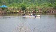
Ames Nowell State Park
Linwood St., Abington, MA 02351 DirectionsAmes Nowell is open year-round for daytime recreation. Cleveland Pond is popular with boaters and fisherman. If you're looking to stay dry, there are several miles of trails along the pond edge and surrounding woods.Phone(781) 857-1336-
Sunrise to sunset
-
-
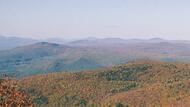
Appalachian Trail
30 Rockwell Road, Lanesborough, MA 01237 DirectionsAppalachian Trail runs 2175 miles, stretching from Georgia to Maine. The trail provides a continuous green pathway through a chain of mountains and hills. Of the vast trail way, 90 miles is home to Massachusetts. Traveling over Mount Everett in the south, all the way up and through Mount Greylock in the north. The Appalachian Trail provides offers hiking for both the long-distance or day hiker.Phone(413) 499-4262-
Park is open dawn to dusk
-
-

Bash Bish Falls State Park
4G85+29, Mt. Washington, MA 01258 DirectionsBash Bish Falls State Park offers scenic viewing of the Commonwealth’s largest waterfall. The dramatic final pitch of Bash Bish Brook drops about 60 feet into an emerald plunge pool.
Sacred to the Mohican and Scaghticoke peoples, it later sparked new scientific thoughts, became an inspiring muse for artists, and an exciting vacation spot. Today, visitors can enjoy moderate to rigorous hikes through the surrounding landscape and stunning views of the falls from a designated viewing area.
Bash Bish is contiguous with Mount Washington State Forest and other preserved lands. Together, they constitute a densely biodiverse habitat for many protected species, and home to old growth forest areas.
Bash Bish Falls connects to Taconic State Park in New York State. Highlights there include the historic Copake Iron Works, Harlem Valley Rail Trail, camping, picnicking, swimming, and hiking.Phone(413) 528-0330-
Sunrise to sunset
-
-

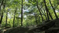
Beartown State Forest
- Wheelchair Accessible
69 Blue Hill Road, Monterey, MA 01245 DirectionsThis 12,000 acre forest is the perfect place to visit no matter the season. Swim, boat, or fish in Benedict Pond. In the winter, you can cross-country ski and snowmobile.Phone(413) 528-0904-
Sunrise to sunset
-
Blackstone River and Canal Heritage State Park
- Wheelchair Accessible
287 Oak St. , Uxbridge, MA 01569 DirectionsThe Blackstone River features 1000 acres of natural park, filled with trails and historical sites. The park also has biking, horseback riding, canoe access, fishing, hunting, picnic areas and more.
The story of River Bend Farm in Uxbridge, MA serves as an example of the story of many farms in the Blackstone Valley. Located about half way between Providence, Rhode Island and Worcester, Massachusetts, River Bend Farm sits at the crossroads of agricultural life, mill villages, transportation routes, and developing town centers. River Bend Farm represents the changing landscape over the last four centuries.
There are fields, open pastures, stone walls, and preserved historical sites that bear witness to a farming past in a valley that witnessed the birth of an industrial revolution.
River Bend Farm today stands as a reminder of the Valley’s long agrarian past. Indeed, glimpses of the Valley’s heritage are evident throughout the region. The landscape tells the story of how everyday life changed with succeeding generations – and how it continues to change today.Phone(508) 278-7604-
Sunrise to sunset
-
Blue Hills Reservation
- Wheelchair Accessible
725 Hillside Street, Milton, MA 02186 DirectionsLocated only minutes from the bustle of downtown Boston, the DCR Blue Hills Reservation stretches over 7,000 acres from Quincy to Dedham, Milton to Randolph, providing a green oasis in an urban environment. Rising above the horizon, Great Blue Hill reaches a height of 635 feet, the highest of the 22 hills in the Blue Hills chain. From the rocky summit visitors can see over the entire metropolitan area. With its scenic views, varied terrain and 125 miles of trails, the Blue Hills Reservation offers year-round enjoyment for the outdoor enthusiast.Phone(617) 698-1802-
Dawn to dusk
-
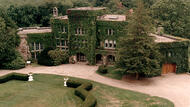
Borderland State Park
- Wheelchair Accessible
259 Massapoag Ave., North Easton, MA 02356 DirectionsBorderland State Park features a historic mansion open for tours. This park also features trails for hiking, biking, or horseback riding, fishing and boating in the pond, and facilities for tennis and disc golf.Phone(508) 238-6566-
Sunday - Saturday:8:00 am-8:00 pm
-

Bradley Palmer State Park
- Wheelchair Accessible
40 Asbury St, Topsfield, MA 01983 DirectionsThis former estate features 721-acres of pine needled paths and sunny rolling meadows for hiking, biking, and horseback riding.Phone(978) 887-5931-
Sunrise to sunset