Purpose
Resource Management Plans (RMPs) are foundational documents that identify a park, forest, or reservation’s defining natural, cultural, and recreational resources and identify potential threats and opportunities to guide DCR’s continued stewardship of the property and to inform future decisions about the property in a way that celebrates and preserves its identity.
RMPs are prepared for “all reservations, parks, and forests under the management of the department” (M.G.L. c. 21, § 2F). These plans “shall include guidelines for the operation and land stewardship of the aforementioned reservations, parks and forests, shall provide for the protection and stewardship of natural and cultural resources and shall ensure consistency between recreation, resource protection, and sustainable forest management.” DCR finalizes RMPs following a public process and adoption by the DCR Stewardship Council. The contents of this RMP represent the best available information at the time of adoption by the Stewardship Council.
Mission and Core Principles
- Provide access to a diversity of outdoor recreational experiences and unique landscapes that is equitable, inclusive, and welcoming.
- Conserve lands, water, and forests by integrating science, research, and technical expertise into the management of our natural resources.
- Advance climate change mitigation and adaptation efforts by implementing sustainable practices and advancing resiliency across our infrastructure, assets, and resources.
- Support healthy communities by providing places for people to connect with nature and each other.
- Inspire generations of stewards by recognizing and honoring our legacy through partnerships, public engagement, and education.
Stewardship
DCR honors Indigenous peoples for their care, throughout many generations, of the land that DCR now stewards on behalf of the people of the Commonwealth. DCR embraces this legacy of stewardship, fostering a sense of shared responsibility by all people for protection of the waters, lands and living things for the enjoyment and appreciation of all.
To learn more about the DCR, its facilities, and programs please visit our web page or contact us at mass.parks@mass.gov.
Summary Tables
1. Property Overview
| Characteristic | Value |
|---|---|
| Date Established | 1978 |
| Location | Boston, Revere, Winthrop |
| Ecoregion | Boston Basin |
| Watershed | Mystic |
| DCR Region | North |
| DCR District | Coastal |
| DCR Complex | Revere Beach |
| Management Forestry District | Northeast |
| Fire Control District | South Middlesex |
| Size (acres) | 225.4 |
| Boundary Length (miles) | 5.0 |
| Elevation - Minimum (feet) | 0.0 |
| Elevation - Maximum (feet) | 23.8 |
| Environmental Justice (acres) | 57.8 |
| Estimated Annual Attendance (2024) | 100,000 |
| Interpretive Programs (number of programs, 2024) | 26 |
| Interpretive Programs (number of attendees, 2024) | 356 |
2. Landscape Designations
| Designation | Acres |
|---|---|
| Parkland | 225.4 |
| Reserve | 0.0 |
| Woodland | 0.0 |
| No Designation | 0.0 |
3. Regulatory Designations
| Designation | Acres |
|---|---|
| Area of Critical Environmental Concern – Rumney Marshes | 224.4 |
| Massachusetts Coastal Zone | 225.4 |
| Outstanding Resource Waters – Belle Isle Inlet | 175.4 |
| Priority Habitat (MESA) | 174.5 |
| Tidelands (Chapter 91) | N/A |
4. Long-Term Agreements
| Agreement | Expiration Year |
|---|---|
| None Identified | N/A |
5. Concessions
| Concession Type |
|---|
| None |
6. Partners & Friends
| Group(s) |
|---|
| Bear Creek Wildlife Sanctuary |
| Brookline Bird Club |
| City of Boston |
| City of Revere |
| Friends of Belle Isle Marsh |
| Mass Audubon |
| Massachusetts Division of Fisheries and Wildlife |
| Mystic River Watershed Association |
| The Nature Conservancy |
| Northeastern University |
| Saugus River Watershed Council |
| The Trustees of Reservations—Waterfront Ambassadors |
| Town of Winthrop |
| UMASS Boston |
| U.S. Army Corps of Engineers—Engineering with Nature |
| U.S. Fish & Wildlife Service |
7. Features of Interest
| Feature |
|---|
| Belle Isle Marsh and Inlet |
| Bird capture and banding station |
| Osprey Nest and camera |
| Views of Boston skyline, Belle Isle Inlet, and Massachusetts Bay |
| Wildflower meadow |
| Wildlife blind |
8. Natural Resources
| Resource | Number |
|---|---|
| Forest Cover (acres) | 25.0 |
| Rivers and Streams (miles) | 2.3 |
| Open Water (acres) | 1.7 |
| Wetlands (acres) | 141.5 |
| Tidal Flat | 32.3 |
| Certified Vernal Pools (number) | 0 |
| Potential Vernal Pools (number) | 0 |
| State-listed Species (number Regulatory) | 4 |
| State-listed Species (number Non-Regulatory) | 1 |
| Federally Listed Species (number) | 0 |
| Aquatic Invasive Plants (number known species) | 2 |
| Terrestrial Invasive Plants (number known species) | 16 |
9. Forest Management (Since 2012)
| Management Objective | Acres |
|---|---|
| None | 0.0 |
10. History of Wildfires and Conditions Influencing Future Wildfires
| Wildfire Attribute | Number or Value |
|---|---|
| Number of wildfires on property; 2020–2024 | 0 |
| Acres burned by wildfires on property; 2020–2024 | 0.0 |
| Number of wildfires in Fire Control District; 2020–2024 | 530 |
| Acres burned by wildfires in Fire Control District; 2020–2024 | 353.0 |
| Type of Wildland-Urban Interface | Intermix |
| Predicted rate of spread, based on Fire Behavior Fuel Model 13 | Rapid |
11. Natural Hazards
| Hazard Type | Acres |
|---|---|
| Flood (1.0%-chance) | 217.0 |
| Flood (0.2%-chance) | 217.0 |
| Hurricane Inundation (Category 1) | 180.3 |
| Hurricane Inundation (Category 4) | 196.3 |
12. Climate Change (By 2070)
| Type of Change | Amount of Change |
|---|---|
| Increase in annual days over 90° F | >30 |
| Change in annual maximum daily rainfall (inches) | >10 |
| Massachusetts Coastal Flood Risk Model area of inundation (acres) | 222.2 |
13. Cultural Resources
| Resource Type | Number |
|---|---|
| Archaeological - listed in the Massachusetts Cultural Resource Information System (MACRIS) | 0 |
| Historical - Listed in MACRIS | 0 |
| National Register-listed | 0 |
| National Historic Landmark | 0 |
14. Recreation Resources
| Resource | Number |
|---|---|
| Accessible Trail (Meadow Loop) | 1 |
| Education & Research Station | 1 |
| Healthy Heart Trail | 1 |
| Mary Kelly Pavilion | 1 |
| Observation Tower | 1 |
| Picnic Area | 1 |
| Trail systems | 3 |
| Viewing/Observation Platforms | 4 |
15. Recreation Activities
| Activity |
|---|
| Bicycling, road |
| Dog walking, on leash |
| Educational Programs |
| Fishing, fin fish |
| Hiking/walking |
| Nature study/photography |
| Picnicking |
| Running/Jogging |
| Scenic Vista viewing |
| Snowshoeing |
| Wildlife viewing |
16. Roads and Trails
| Metric | Value |
|---|---|
| Roads - Unpaved (miles) | 0.3 |
| Roads - Paved (miles) | 0.3 |
| Forest Roads - Unpaved (miles) | 0.2 |
| Forest Roads - Paved (miles) | 0.8 |
| Trails - Unpaved (miles) | 2.1 |
| Trails - Paved (miles) | 0.1 |
| Trails - Unauthorized (miles) | 0.2 |
| Trail Density (miles/acre) | 0.015 |
| Area of Impact (acres) | 149.3 |
17. Parking
| Parking Resources | Number |
|---|---|
| Lots | 2 |
| Parking Spaces – Total | 59 |
| Parking Spaces - Accessible (HP) | 4 |
| Parking Spaces – Other | 55 |
Introduction
Belle Isle Marsh Reservation (or, the Reservation) is located in the East Boston neighborhood of Boston, the City of Revere, and the Town of Winthrop, approximately 4 miles northeast of downtown Boston. The Reservation preserves a portion of the greater Belle Isle Marsh salt marsh complex (the marsh) along Belle Isle Inlet (also known as Belle Isle Creek) and its Short Beach Creek tributary. The marsh complex is almost entirely conserved through a combination of DCR and municipal ownership, with DCR owning approximately 75 percent of the marsh’s open space. Belle Isle Inlet runs roughly north-south through the Reservation and opens onto the north side of Boston Harbor (see Figure 1. Land Stewardship Zoning Map). To the northeast, Short Beach, a bay barrier beach, separates the marsh and Reservation from Massachusetts Bay. The marsh and creeks are located between a combination of filled former tidelands and uplands occupied by the neighborhoods of Orient Heights (to the west), Beachmont (to the north), Winthrop Highlands (to the east) and Winthrop center (to the south). Logan Airport is 0.5 miles southwest of the Reservation, which is below aircraft flight paths.
The Reservation is one of multiple DCR properties in communities along the north edge of Boston Harbor. Within a one-mile radius are Constitution Beach (to the southwest), Revere Beach Parkway and Revere Beach Reservation (to the north), Winthrop Shore Reservation and Winthrop Parkway (abutting to the east), and Winthrop Shore Drive and additional components of Winthrop Shore Reservation (to the southeast). All of these properties were constructed by one of DCR’s predecessors, the Metropolitan District Commission (MDC); many were conceptualized as part of the interconnected Metropolitan Park System for Greater Boston (Adams et al. 2004).
Belle Isle Marsh Reservation is composed of four tracts separated by non-DCR-owned marsh or open water that prevent direct access from one tract to another and sometimes limit circulation within the same tract. Beginning with the Main Reservation in East Boston and moving clockwise; they are:
- Main Reservation. This tract in East Boston contains the Reservation’s Main Gateway (i.e. main identification sign, driveway, and parking lot). Its major boundaries are Belle Isle Inlet, to the east and north, and Bennington Street, a major urban thoroughfare, to the west. To the southwest are a compact residential neighborhood and the Massachusetts Bay Transportation Authority’s (MBTA) Orient Heights Maintenance and Storage Facility. The MBTA’s Suffolk Downs and Beachmont stations on the Blue Line are both less than 0.5 miles from the Main Gateway. In addition to the gateway, the Main Reservation contains a large proportion of the park’s developed recreation infrastructure, including the Meadow Loop Trail, observation tower, and several overlooks. This developed area was built on the site of the former Suffolk Downs Drive-In Theatre and, in some early MDC reports, was referred to as Belle Isle Marsh Park.
- Short Beach Tract. Located in Revere and Winthrop, this tract lies to the east of the Main Reservation and Belle Isle Inlet. To the north is the edge of the Beachmont residential neighborhood and a portion of Belle Isle Marsh owned by the City of Revere. To the east are Winthrop Parkway and residential housing along Revere Street. To the southwest are Belle Isle Cemetery and a portion of Belle Isle Marsh owned by the Town of Winthrop. Short Beach Creek divides the tract. The tract’s southeasterly portion contains a small parking lot and the John Kilmartin Walkway (also known as the Kilmartin Path, hereinafter referred to as the Kilmartin Walkway). The northwesterly portion of the tract contains “the key.” This causeway and berm assemblage, which has a key-shaped appearance from the air, is the remains of a mid-twentieth century aircraft navigation system (Harris 2023). Town of Winthrop sewer infrastructure (built circa 1889) runs through the tract, subject to unknown legal takings or easements (Clark 1952: 172; Town of Winthrop 2024; Whitman & Howard 1906: Sheet 22).
- Marine Ecology Park Tract. This tract in Winthrop, composed of a single land parcel, is located on the east side of Belle Isle Inlet. To the west, north, and northeast are portions of the marsh owned by the Town of Winthrop. Morton Street and associated residential developments are located to the south and southeast. This tract contains the Mary Kelley Pavilion and a portion of the Marsh Walk, a Town of Winthrop initiative that connects to non-DCR conservation lands.
- Saratoga Street Tract. This tract in East Boston is a single land parcel on the north edge of Saratoga Street. It is bounded to the east by Belle Isle Inlet (bridged by Saratoga Street), to the north by marsh owned by the City of Boston and by the MBTA Orient Heights Maintenance and Storage Facility, and to the west by small-scale commercial and office development. The Metropolitan Water Resources Authority’s (MWRA) North Metropolitan Trunk Sewer (built 1895) runs through the tract below a raised earth causeway or berm, subject to an easement (MWRA 2006: 9-14, 9-32; Suffolk County Registry of Deeds (SCRD), Book 1952, Page 312 and Book 1955, Page 516). The sewer’s gravel-surfaced causeway is informally used by recreationists as a trail to the edge of Belle Isle Inlet and into the City of Boston’s marsh parcel.
Belle Isle Inlet and Belle Isle Marsh create the predominate setting for the Reservation. The marsh and inlet as they exist as of 2026 are the remnant of what was a larger, connected estuarine system around the Mystic River and Boston Harbor that consisted of tidal waterways, salt marsh, and barrier beaches, all punctuated by glacial drumlins. This coastal wetland system extended north to Young’s Hill in Revere, west to Chelsea, and south around the periphery of East Boston (formerly an island) to Boston Inner Harbor (i.e., confluence of Mystic and Charles rivers). Belle Isle Marsh and Inlet were over 600 acres and wrapped around the north side of the drumlin now called Orient Heights to connect with the Chelsea River. Remnants of this watercourse to the west of the Reservation are now called Sales Creek (Mastone et al. 2011: 5, 29–40).
The Reservation is on land shaped by generations of Indigenous peoples and non-Indigenous inhabitants. Past and present Indigenous residents embody fluid, relational connections to the places and spaces now known as Belle Isle Marsh Reservation. Indigenous peoples are recorded in available documentation as having relationships to this place over seasons and generations. Belle Isle Marsh was a part of a rich coastal resource area for horticulture, hunting, fishing, and gathering, and other cultural practices, as evidenced in the archaeological record and the current interest of tribes, who continue to maintain a connection to their ancestral homeland (Massachusetts Historical Commission (MHC) 1981a, 1981b; Mastone et al. 2011). Tribal governments such as the Herring Pond Wampanoag Tribe, the Mashpee Wampanoag Tribe and the Wampanoag Tribe of Gay Head (Aquinnah), and Indigenous communities such as the Massachuset and Mattakeeset have interest in the history, continued use, and relationship with the area.
Following Indigenous peoples’ dispossession through disease and the arrival of the English Puritans, Pilgrims, and other separatists, the lands around Belle Isle Marsh were divided into large farm estates by the early 1630s. Orient Heights—called Hog Island at that time—was used for pasture. The island would later be known for a short time as Belle Isle, thus giving its name to the marsh (Mastone et al. 2011: 6; Seasholes 2003: 367–368). Winthrop and Revere, originally called Pullin Point and Rumney Marsh, respectively, were both annexed to Boston in 1634 (MHC 1981a: 1; 1981b: 1). During the 17th, 18th, and 19th centuries, New England farmers employed a variety of techniques for the hydrological alteration of salt marshes to improve agricultural productivity. These techniques may have been employed within current Reservation boundaries (Adamowicz et al. 2020). Subsequently, landfilling, urbanization, and hydrological engineering of the larger estuarine system dramatically changed the size and hydrological characteristics of Belle Isle Marsh. Important milestones in this history include: construction of embankments for Bennington Street and two railroad rights-of-way (ROW) in the 1870s, regulation of Belle Isle Inlet and Sales Creek using tide gates beginning in 1895, filling of the marsh west of Bennington Street along Sales Creek beginning in the 1930s, and completion in 1982 of the Alfred H. Long Pumping Station (hereafter referred to as Long Pumping Station, part of a larger U.S. Army Corps of Engineers (USACE) flood risk reduction program) in the Sales Creek catchment area (Board of Harbor Commissioners 1877: 24; 1878: 35; Board of Harbor and Land Commissioners 1896: 35; Friends of Belle Isle Marsh (FBIM) 1983: n.p.; Seasholes 2003: 367–368). (See Seasholes (2003) for an authoritative history of landfilling activities around Boston.) During the 1930s, the entire marsh was ditched for mosquito control and a 7,000-foot-long berm (called the L-berm) was constructed in the East Boston portion of the Marsh (Riley 2020: n.p.; State Reclamation Board 1931: 5; 1932: 21–22). Belle Isle Inlet adjacent to the Reservation has been dredged on multiple occasions, since at least as early as 1934 (Massachusetts Department of Public Works (DPW) 1936: 76). This land use history in and around the current Reservation has contributed to the challenges that the marsh ecosystem faces as of 2026 (see Natural Resources Threats, Opportunities, and Priority Recommendations sections).
During the 1960s and 1970s, intersecting trends and events led the MDC to create Belle Isle Marsh Reservation. At the state level, there was an increasing appreciation of and desire to protect coastal wetlands that was evidenced in several actions. These included a state-wide Department of Natural Resources (DNR) study of coastal wetlands that culminated in a 1964 report on their ecosystem services and economic value (DNR 1964), passage of the Jones Act (c. 426, Acts of 1963; Massachusetts General Court (MGC) 1963) regulating the destruction of coastal wetlands, and protection of Belle Isle Marsh from illegal dumping through c. 167, Acts of 1964 (MGC 1964). The DNR study report included a list of wetlands with priorities for public preservation that included Belle Isle Marsh (DNR 1964: 48). Within Greater Boston, regional planners, including the Boston Redevelopment Authority (BRA), were identifying and working to preserve the last “Urban Wilds” of the area, including Belle Isle Marsh (Boston Natural Areas Fund 1991: 1–2; BRA 1976: 22, 23, 42). The East Boston community desired more parkland and recreational access to water after the Massachusetts Port Authority (Massport) demolished Wood Island Park in 1969 (BRA 1977: 16–19; Gard 1984: 30). Finally, a sense of urgency to protect Belle Isle Marsh was created when Massport proposed creating an oil terminal in the marsh and the Suffolk Downs Drive-In Theater closed and was listed for sale (FBIM 2023).
Individual MDC and City of Boston officials proposed public conservation of Belle Isle Marsh in 1968 and 1971, respectively, but formal MDC action did not begin until 1973, when MDC staff prepared a proposal and conceptual design for a “Belle Isle Reservation.” The proposal envisioned conservation of all of the available marsh land, walking paths with viewing locations for visitors to look at the marsh, and (on pre-existing filled areas) a skating rink, athletic courts, football field, and swimming pool (Gard 1984: 90–91; Falk et al. 1973; Furniss and Falk 1973; Stone 1971: 16). The values of the prospective reservation as identified in these planning documents persists at the Reservation today: ecological diversity, open space and recreation, aesthetics, public access, education, and ecosystem services (e.g., flood control and coastal surge protection, and fisheries nursery) (Furniss and Falk 1973: 2–6). The MDC Commissioners took up the proposal and, after further deliberation and assessments, began land acquisitions in 1975. The first parcel acquired was the Suffolk Downs Drive-In Theater lot in East Boston, which now falls within the Main Reservation (SCRD, Land Court Document No. 324437). Funding came from a 1970 state-wide bond bill (MGC 1970), as amended in 1971 to include “not less than two million dollars for the acquisition of land and the construction thereon of a covered skating rink, year-round swimming pool and related athletic facilities in the East Boston section of the City of Boston” (MGC 1971). Additional funding for land acquisition and recreational development was appropriated in 1976 (MGC 1976). However, funding was not adequate for all the planned amenities. Consequently, MDC consultants developed a simplified master plan that omitted the rink, courts, football field, and pool but retained the passive recreation amenities (e.g. parking lot, trail, island, meadow, and viewing tower) that are still extant as of 2026 (Moriece and Gary, Inc. 1978: 24–25). While planning and construction proceeded, the MDC, in 1979, acquired over 100 acres of adjacent Massport-owned marsh. This acreage completed what is now the Main Reservation and created the Saratoga Street Tract (SCRD Document No. 324437). Belle Isle Marsh Reservation was “officially dedicated” in June 1978 and the park facilities (then referred to as “Belle Isle Park”) opened to the public in September 1986 (Driscoll 1987: 4, 5).
In addition to acquisitions for the Main Reservation and Saratoga Street Tract, the MDC and DCR have added additional lands to the Reservation as follows:
- The Short Beach Tract. The Revere portion of this tract, which is a single land parcel, was acquired by the Massachusetts DPW in 1941 to build and operate an aircraft navigation beacon (now removed) (SCRD Book 5997, Page 176; authorized under chapter 695, Acts of 1941). The parcel was under control of the DPW’s Waterways, which was transferred to the Department of Environmental Management, which was subsequently incorporated into DCR (Comeau 2017). The Winthrop parcels in this tract were used as a private dumping ground. MDC acquired this land in 1993 (SCRD Book 18570, Page 271). Restoration and development for passive recreation occurred in the early 2000s. Chapter 457, Acts of 2010 designates the multi-use trail in this tract the “John Kilmartin Walkway” and requires that the DCR mark it as such (MGC 2010).
- Marine Ecology Park Tract. This land, formerly known as the Bonacorso property and used as a private storage area and dumping ground, was acquired in 1999 and subsequently remediated (FBIM 2015; SCRD Book 23806, Page 181). Operating under a license from DCR that expired in 2021, the Town of Winthrop landscaped the parcel and built the Belle Isle Path (i.e., the Marsh Walk, mostly consisting of an elevated boardwalk) and Mary Kelly Pavilion (an elevated viewing platform) (Massachusetts Executive Office of Housing and Economic Development 2017; Town of Winthrop n.d.; Woods Hole Group (WHG) 2022a: Appendix B).
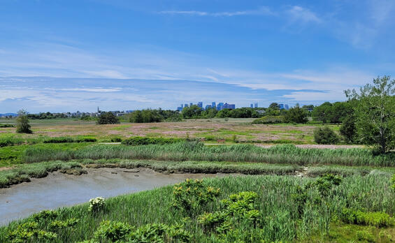
Belle Isle Marsh Reservation is a unique and precious natural resource that allows visitors to experience a salt marsh within view of the Boston skyline while preserving a glimpse of Boston Harbor as it might have looked before urbanization. Composed of a combination of uplands, salt marsh, and small areas of freshwater tidal wetlands, the Reservation encompasses the variety of natural community types (e.g. Shrublands, Brackish Tidal Marsh, Tidal Flats, Coastal Forest) and associated hydrological regimes (i.e., from subtidal to transitional marsh) that typify a Massachusetts salt marsh environment and setting. The upland areas support the primary visitor experiences of the Reservation. Much of the upland acreage consists of former industrial sites that the MDC and DCR have capped or otherwise remediated prior to conversion to parkland. Passive recreationists may picnic in a small grove, walk through a naturalized meadow, or stroll stone dust trails and access viewing platforms to observe wildlife along the edge of the marsh. The Reservation’s outstanding setting offers contrasting natural resources and urban infrastructure that create distinctive scenic views. Importantly, visitors from nearby urban communities may easily access the Reservation travelling on foot or via rapid transit. In the summer, the property’s shade trees and ocean exposure provide a cool respite from the developed neighborhoods that surround the Reservation.
Simultaneously, the Reservation offers unmatched conservation value for Greater Boston and the Commonwealth as it protects the last salt marsh on Boston’s mainland—a reminder of the greater estuarine ecosystem and wildlife habitat that once existed throughout Boston Harbor. Interpretive programming, special events, and scientific studies at the property engage the public with the Reservation’s natural history. Research conducted at Belle Isle Marsh enhances DCR’s natural resource management, as well as the management of other North American salt marshes, by providing important data that may be contextualized within other such ecosystems in the country. As of 2026, this data is increasing in importance due to its applicability to climate change and adaptation policy and programs, both for conservation purposes and for community preparedness.
Belle Isle Marsh Reservation is within the larger Rumney Marshes Area of Critical Environmental Concern (ACEC). Communities within ACECs may prepare ACEC RMPs, subject to guidelines published by the Secretary of Environmental Affairs and the DCR (Coxe 1996; DCR 2004). This Belle Isle Marsh Reservation RMP does not function as, nor substitute for, such an ACEC RMP. This RMP is limited in application to the bounds of the Reservation and the associated resources under the care, custody, and control of DCR.
Park Identity
Belle Isle Marsh Reservation’s identity is consistent with its founding objectives: a property that conserves a significant saltmarsh system and its ecosystem services, while providing important open space, passive recreation opportunities, and an environmental education venue to residents of surrounding towns and municipalities.
All future activities and improvements should, consistent with the Reservation’s Parkland Landscape Designation (see DCR 2012a), provide for continued public access and enjoyment of the property’s open space for passive recreation. Simultaneously, Reservation management must encompass protections for the salt marsh that defines the property, provides habitat for multiple species, and offers unique conservation values for Boston, Revere, Winthrop, and surrounding urbanized communities.
Site-specific environmental studies (e.g. WHG 2022a; 2022b) demonstrate that climate change impacts are likely to pose an existential threat to the saltmarsh portion of the Reservation, and thus to the Reservation’s identity, within the next 75 years (see discussions in the Climate Change section, below). In recognition of this threat, DCR should: 1) continue to study causes and possible solutions for degraded areas of saltmarsh; 2) protect and restore saltmarsh habitat and enhance the resilience of the saltmarsh; and 3) if possible, prolong the existence of the Reservation as an important green space for surrounding communities. Achieving these goals requires the cooperation of other marsh owners and partners. Such work is also subject to and dependent on the Commonwealth’s state-wide climate resilience and adaptation policies and priorities.
Defining Resources and Values
Resources and values that define Belle Isle Marsh Reservation are related to its location within and adjacent to Belle Isle Marsh and Belle Isle Inlet and tributaries, juxtaposed with the property’s urban setting. They include:
- Belle Isle Marsh, Belle Isle Inlet, and Short Beach Creek. These natural features are the heart of the Reservation, geographically, ecologically, and experientially. They host important natural resources and many of the property’s recreational activities are organized around these features.
- Conservation of diverse, unique, and significant natural resources within an “urban wild” setting. The qualities described below make Belle Isle Marsh significant within both the context of state-wide conservation and the Commonwealth’s state parks system. The marsh’s ecological importance is recognized through multiple designations: the Rumney Marshes ACEC, a U.S. Fish & Wildlife Service (USFWS) Biologically Significant Estuary, a Massachusetts Department of Environmental Protection (MassDEP) Outstanding Resource Water, and a Mass Audubon Important Bird Area. Noteworthy conservation values and resources are:
- Estuarine habitat and related ecosystem services. The Rumney Marshes ACEC, including Belle Isle Marsh, is “one of the most biologically significant estuaries in Massachusetts north of Boston” and is important for flood control, the prevention of storm damage, the protection of land containing shellfish, and fisheries [some of which are commercially and recreationally important]; the prevention of pollution, the protection of wildlife habitat, and the protection of public and private water supplies (USFWS, as quoted in Secretary of Environmental Affairs 1988: 7). Belle Isle Marsh is the largest remaining salt marsh in Boston and largest single wetland in the City (City of Boston Parks and Recreation Department 2023: 57).
- The combination of salt marsh and open meadow habitats with a location along the Atlantic Flyway makes the Reservation an important bird habitat for breeding, seasonal foraging, and migratory staging and stopovers (Riley 2020). 272 native species, approximately half of all bird species recorded in Massachusetts, have been observed in the Reservation (eBird.com 2025). Although bird species counts are not maintained across all DCR properties, the recorded 272 bird species, which is second only to Halibut Point State Park’s 287 species, makes the Reservation one of the top DCR properties for avian diversity. The Natural Heritage & Endangered Species Program (NHESP) has designated Priority Habitat in the Reservation for four bird species protected under the Massachusetts Endangered Species Act (MESA). As of 2026, the USFWS was reviewing the status of one of these, the salt marsh sparrow, under the Federal Endangered Species Act (USFWS 2024a). Additionally, six MESA-protected bird species, two of which are protected under the Federal Endangered Species Act, frequent the property but do not have associated Priority Habitat. (NHESP policies prevent DCR from revealing in public documents the presence and location of specific MESA-protected species. However, the presence of the saltmarsh sparrow in the Reservation has already been publicized in non-agency publications and is therefore discussed in this RMP.)
- At least 27 species of mammals, including many that are unusual or not present in other parts of Boston (e.g. muskrat) (Riley 2020: n.p.).
- As of 2016, a significant, breeding horseshoe crab population was in the Reservation. As of 2026, the horseshoe crab was under consideration by NHESP for addition to the MESA-protected species list (NHESP 2023).
- The Reservation contains examples of multiple natural community types that are designated as NHESP Priority Natural Communities: Brackish Tidal Marsh, Salt Marsh, and Maritime Shrubland (Swain 2020: 15, 17, 18, 319).
- Two meadows (one approximately 13 acres, one 2 acres) are managed as Cultural Grassland Community to provide pollinator (including monarch butterfly) and ground-nesting bird habitat that is unusual in Boston. (Meadow management occurs in consultation with the NHESP.)
- Collaborative scientific study of saltmarsh systems, associated natural community types, and species. Thirteen different federal and state agencies, academic institutions, and environmental organizations partner with DCR to conduct environmental research and education initiatives. Bird research, conducted under the auspices of the Belle Isle Marsh Banding Station, is a particular focus of Reservation studies (Riley 2023). The Belle Isle Marsh Banding Station is the only bird banding station within DCR and the only such station operating in the greater Boston area. Operation of the Banding Station has allowed DCR to conduct, or to collaborate on, scientific studies and educational initiatives relating to urban raptors, breeding songbirds, salt marsh sparrows, and osprey. Saltmarsh sparrow studies at the Reservation pioneered new methodologies for population census reviews of the species (Kernan and Riley 2023).
- Studies on climate change and ecosystem services. Coastal wetlands are recognized as being vulnerable to sea level rise and other impacts from climate change, while also providing resiliency for other coastal resources that are subject to such impacts. The Reservation and larger marsh are the focus of several studies in which DCR and partners are exploring strategies to enhance climate resilience and adaptation of coastal wetland ecosystems and their surrounding communities. (The studies and attendant funding are managed on a case-by-case basis with DCR and partner staff in assorted committees. For convenience, these assorted working groups will hereafter be uniformly referred to as “marsh committees.”)
- Belle Isle Marsh Reservation is designated as a study site for coastal wetland modeling and restoration assessment in the Commonwealth’s 2023 “ResilientMass” State Hazard Mitigation and Climate Adaptation Plan (Commonwealth of Massachusetts 2023: 7-47).
- Belle Isle Reservation is on a short list of marshes in Massachusetts that are designated a “priority” (the highest ranking) for saltmarsh sparrow conservation work within the Atlantic Coast Joint Venture’s (ACJV) Saltmarsh Restoration Priorities for the Saltmarsh Sparrow: Massachusetts (ACJV 2022: 11; USFWS 2024b). (See the Threats and Opportunities and Climate Exposure and Impacts sections.)
- The Massachusetts Bays National Estuary Program (MassBays), in collaboration with DCR partner Mystic River Watershed Association (MyRWA), is testing a new concept at the Reservation—the Ecosystem Services Gradient—to model the benefits to humans that estuarine habitats provide and to link environmental restoration with social and economic benefits within community planning work. The work at Belle Isle Marsh will be used as a pilot study to better understand the benefits of the Ecosystem Services Gradient for other estuarine restoration projects.
- The USACE Engineering with Nature (EWN) Initiative has implemented a study at Belle Isle Marsh. The EWN process integrates engineering and ecology to create collaborative approaches to infrastructure development and environmental management. The study will provide engineering, design, and permitting guidance for marsh restoration work by DCR and other members of marsh committees and apply lessons learned to other coastal marsh ecosystems in urban areas (USACE n.d., 2023, 2024).
- Research at the Reservation and other DCR properties on the topic of salt marsh cordgrass (Spartina alterniflora) may enhance scientific understanding of how to assess a marsh’s vulnerability to sea level rise (Sperry and Hughes 2023).
- Belle Isle Marsh Reservation is a recreational resource of regional importance because it provides access to a unique coastal resource for residents of the Greater Boston metropolitan region. The property is a relatively undeveloped wild area that is within easy reach of rapid transit and adjoins multiple residential sections of East Boston, Revere, and Winthrop. Important or unique aspects of recreation at the Reservation include:
- Large open space—the Reservation is the biggest single green space in East Boston.
- The opportunity to observe and enjoy estuarine and meadow ecosystems, habitat, wildlife, and scenery. The Reservation is a highly popular and well-known recreational birding site (Bishop and Zendeh 2014; Mitchell 2008: 31, 214). An osprey nest in the Reservation may be viewed via an internet-linked digital video camera, nicknamed the Ospreycam.
- Passive recreation on the Reservation’s trail system, some components of which are accessible.
- Connections to other conserved lands and corridors through multi-use trails and marsh boardwalks: the Belle Isle Path and John Kilmartin Walkway.
- Unique scenic vistas that extend up to 12 miles and provide dramatic contrasts of urban infrastructure and the marsh. The views extend across Belle Isle Marsh to Massachusetts Bay, surrounding uplands (drumlins) of Revere and Winthrop, the downtown Boston skyline, and the Blue Hills.
- The Reservation provides recreational amenities to, and enhances environmental quality and equity for, Environmental Justice (EJ) communities.
Critical resources that support these recreational activities are the various trails and observation points, especially the Meadow Loop Trail and mown pedestrian pathways within the meadow, the observation tower (possibly the Reservation’s most popular destination), Kilmartin Walkway, Mary Kelly Pavilion, and a picnic area.
- Environmental education. Agency staff and partners have recognized the Reservation’s outstanding education value since its inception, due to the property’s unique status as a salt marsh urban wild. Reservation staff and partner organizations conduct a variety of public outreach and education programs for visitors of all ages. Because some of the scientific research (e.g., saltmarsh sparrow monitoring) is unique within the Agency and deals with bellwether species for climate change, these educational programs highlight DCR’s stewardship mission. Approximately 40 such programs are presented each year. The Education & Research Station (a small shed obtained with the assistance of the FBIM) houses educational materials for programming.
Statements of Significance
Statements of Significance describe the importance or distinctiveness of a place and its resources (National Park Service (NPS) 1998). These statements reflect current scholarly inquiry and interpretation and go beyond a simple listing of resources to include contextual information that makes the facts more meaningful. When developing significance statements, the following criteria are considered:
- The property’s significance at the time of its establishment.
- How the property, or society’s understanding of the property, has changed since its acquisition that makes it significant or unique within the state park system today.
- The property’s role in recreation and its importance to the community it supports, particularly regarding activities that are unique to that property.
For park planning, these statements focus management actions on the preservation and enjoyment of those attributes that most directly contribute to the importance of the place. For interpretive planning, they comprise the information upon which the interpretive themes and overall program are built.
The following Statements of Significance have been identified for Belle Isle Marsh Reservation. The sequence of these statements does not reflect their level of significance.
- Belle Isle Marsh Reservation is part of the Rumney Marshes ACEC, recognized as one of the most biologically significant estuaries north of Boston, providing essential functions such as flood control, storm damage prevention, shellfish nursery and fisheries protection, pollution prevention, and wildlife habitat preservation.
- As a coastal site along the Atlantic Flyway, Belle Isle Marsh Reservation serves as a vital resting, migratory, and nesting area for a diversity of bird species, including those that are threatened or at risk of extinction.
- Belle Isle Marsh Reservation functions as a significant natural oasis amidst the urban development of Boston, Revere, and Winthrop, offering a place of renewal, connection, and protection for both its human and wildlife residents.
- The Reservation fosters essential environmental research and education by collaborating with academic institutions and federal and state agencies. It operates an important urban coastal bird banding station in New England, enhancing scientific understanding, and promoting public engagement.
- Belle Isle Marsh Reservation contains multiple examples of NHESP Priority Natural Communities, including Brackish Tidal Marsh, Salt Marsh, and Maritime Shrubland, contributing to the conservation of rare and significant habitats.
Unifying Theme
The Unifying Theme is a statement that ties a property’s stories together and shapes the overall interpretive message that DCR wants to share with visitors in their experience at the property. The theme provides an overarching conclusion for visitors to contemplate (Ham 2013) and answers the question “so what?” The theme guides all interpretation for the park, both personal (i.e., formal and informal interactions with visitors) and non-personal (e.g., exhibits, signage, brochures).
The Unifying Theme for Belle Isle Marsh Reservation is:
Life finds a way in the heart of the city. Belle Isle Marsh stands as a resilient sanctuary for wildlife and people, inspiring active discovery and stewardship.
Visitor Experience
Belle Isle Marsh Reservation provides a variety of visitor experiences, including the following:
- Virtual Experience. Potential visitors will find information about Belle Isle Marsh Reservation on DCR’s web site. The Reservation has its own web page that provides potential visitors information needed to plan a visit.
- Entering the Park. The Reservation’s well-kept main gateway provides access to the Main Reservation from Bennington Street in East Boston. A short driveway leads to a parking lot, where visitors will find a kiosk with park information at a trailhead. From this location, visitors may walk or bike on the Reservation’s stone dust and asphalt multi-use trails. A secondary trailhead for the Main Reservation is located on Lawn Avenue in East Boston, where visitors may access the property on foot. Austin Avenue along the Main Reservation is a private way where DCR staff have deeded access, but the general public do not (WHG 2022a:10). A second important entrance to the Reservation is located on the Winthrop Avenue frontage of the Short Beach Tract. Here, visitors arriving by vehicle may park in a small, paved parking lot and access the Kilmartin Walkway. A pedestrian trailhead for the Short Beach Tract is also located in Revere, at the end of Summer Street, where visitors may walk onto the “key” atop a raised causeway through the marsh. The Saratoga Street Tract has no formal entrance. Visitors wishing to access this location must do so from a private parking lot, behind commercial buildings that front the street. From this location, visitors may walk around a DCR gate onto a gravel trail atop the MWRA sewer easement.
- Trail-based Passive Recreation. Visitors may access a combination of multi-use and pedestrian trails in the Reservation. Multi-use trails consist of the Main Reservation’s loop trail around the meadow with a spur to the observation tower and viewing platforms, the Kilmartin Walkway on the Short Beach Tract, and a small loop on the Marine Ecology Park Tract. These are paved trails surfaced with asphalt and stone dust. In several locations, natural surface, pedestrian spur or connecting trails access the meadows and other features of interest on the property. The multiple-use trails on the Marine Ecology Park and Short Beach Tracts connect to the Town of Winthrop-owned Belle Isle Path.
- Picnicking. A small group of picnic tables is located in a grassy area between the parking lot and the meadow of the Main Reservation and allows visitors to gather for snacks or brief meals. There are no grilling facilities.
- Boating. There is no formal boating access or infrastructure in the Reservation. However, DCR and partners occasionally offer programs in which visitors use car-top boats (i.e., canoes or kayaks) on Belle Isle Inlet. The craft are launched from shoreline locations near the observation tower. Other boaters may enter Belle Isle Inlet after launching from locations outside of the Reservation. (The inlet was formerly dredged for larger watercraft, a practice that is discontinued.)
- Fishing. Although not a popular destination for fishing, visitors occasionally fish in Belle Isle Inlet from shoreline accessed via the Reservation, or from small craft on the Inlet.
- Programs and Special Events. Belle Isle Marsh Reservation hosts a variety of community and educational events. Depending on the season, DCR offers bi-weekly nature walks, as well as special programs on the topics of saltmarsh ecology, saltmarsh sparrow monitoring, winter raptor identification, animal tracks and sign, bio-mimicry, climate resilience, and backyard animals. The FBIM hosts an annual Fall Harvest Festival (i.e. Fall Fest), and several other special programs (totaling about 5 per year). The Trustees of Reservations hosts a free monthly birdwatching walk.
Threats and Opportunities
The following information identifies potential threats to the park’s natural and cultural resources and identifies opportunities to enhance their protection and stewardship. Although recreation is not considered a resource under statute (M.G.L. c. 21, § 2F), it is included below because recreation is an important part of the park-going experience, helps define a park’s values, and is a key part of assessing the consistency of activities taking place in the Commonwealth’s forests, parks, and reservations.
Threats and opportunities identified below are used to inform the development of management recommendations. Potential recommendations must meet prioritization criteria to be included in the Priority Recommendations table (Table 19).
Natural Resources
Threats
- There is currently no RMP for the Rumney Marshes ACEC (ACEC RMPs are distinct from this RMP, which is prepared by DCR exclusively for property under the care, custody, and control of the agency. ACEC RMPs are prepared by community and municipal partnerships for all lands within the ACEC, regardless of ownership.). Lack of an ACEC RMP may limit comprehensive stewardship of the Reservation, including identification of climate change and adaptation strategies for the saltmarsh. (The Rumney Marshes ACEC: Salt Marsh Restoration Plan, now partially obsolete, does not function as an ACEC RMP (Massachusetts Wetland Restoration Program and MassDEP 2002)).
- Portions of the Short Beach Tract are located within a barrier beach area (designated Rv-2 and Wn-1), as inventoried by the Massachusetts Office of Coastal Zone Management (CZM). Barrier Beach Management Plans are required for these areas under Executive Order No. 181: Barrier Beaches (King 1980). However, there is no such management plan. Appropriate management of the Short Beach Tract within the Reservation is threatened by the lack of such a plan.
- An environmental assessment (including a wetland cover type map with field-based ground truthing) has been conducted for the entirety of the Belle Isle Marsh (i.e., not limited to Reservation boundaries): the Belle Isle Environmental Inventory, Coastal Modeling, and Restoration Assessment (referred to hereafter as the Environmental Inventory; WHG 2022a). The Environmental Inventory compiles historical alterations and current conditions that negatively impact the marsh. These impacts are resulting in marsh degradation and loss of habitat and Priority Natural Communities (i.e., Brackish Tidal Marsh, Salt Marsh, Freshwater Tidal Marsh) through multiple processes:
- Outside of the marsh, landfilling and berms to facilitate and protect development and transportation infrastructure restrict tidal flow, limit freshwater runoff, and fragment the marsh. Resultant altered salinity levels and concentrated sedimentation promote invasive common reed growth in large sections of the marsh. Limited hydrological connections to the inland watershed reduce sediment inputs, lowering lower marsh accretion rates and making the marsh vulnerable to drowning.
- Modifications within the marsh such as raised earth berms (e.g., the L-berm and key; see Introduction) and mosquito ditches negatively alter marsh hydrology. In some locations, mosquito ditches result in excessive marsh drying, peat oxidation, and subsidence. In others, berms and ditches cause poor low tide drainage (i.e., low tide attenuation) that degrades habitat through oversaturation and elevated water temperatures. This may degrade Priority Habitat for MESA-protected species in the Reservation. Mosquito ditches increase mosquito populations by eliminating natural predators from breeding areas.
- Water quality is impaired due to development that creates stormwater and sediment runoff containing pollutants and excessive nutrients. These impair marsh plant health, which leads to collapse of marsh edges subject to tidal pull and to dieback within the marsh’s interior. Collapse has been observed at several locations and is expected to continue. Sea-level rise due to climate change may exacerbate this trend (see Climate Change section below). Poor water quality and attendant decreases in dissolved oxygen may have caused fish kills in the past. Sediment contamination may also be present within the marsh.
- During heavy rain events, freshwater accumulates within the Sales Creek catchment area and then is released into the marsh via the Long Pumping Station and Sales Creek tide gate. These freshwater pulses affect marsh salinity levels. Contaminants are not removed before water is ejected into the marsh.
- Three Priority Natural Communities have been identified in the Reservation. These communities, and existing and potential threats to their ecological integrity and continued persistence in the Reservation are identified below:
- Brackish Tidal Marsh (S2 – Imperiled). Multiple examples of this community type are located on the Main Reservation, Saratoga Street Tract, and Short Beach Tract. Invasive species, particularly common reed, are the primary threat to this community type (Swain 2020: 283).
- Maritime Shrubland (S3 – Vulnerable). This community type is only located on the Main Reservation. Invasive species are the primary threat to this community type (Swain 2020: 80).
- Salt Marsh (S3 – Vulnerable). This community type, which has both high and low marsh habitat components, is located throughout the Reservation. It is vulnerable to invasive species, coastal development, coastal erosion, tidal restrictions, stormwater flows and land source impacts, filling, dredging, and ditching (Swain 2020: 298).
- The following 18 species of terrestrial or aquatic Invasive plants (i.e., those categorized as Invasive by the Massachusetts Invasive Plant Advisory Group (MIPAG) (2024)) have been identified in the Reservation: showy fly honeysuckle, non-native shrub honeysuckle, broadleaved pepperweed, common buckthorn, glossy buckthorn, Norway maple, tree of heaven, purple loosestrife, Oriental bittersweet, reed canarygrass, autumn olive, Louise’s swallow-wort, black locust, common reed, multiflora rose, Japanese knotweed, garlic mustard, and mile a minute vine. Louise’s swallow-wort is an Early Detection Priority Species (or priority invasive species) given the highest priority for field survey and management (BSC Group, Inc. 2017: 5). Two Likely Invasive plants, Amur peppervine and common barberry, are also present. Invasive species may negatively impact both the ecological integrity and biodiversity of the Reservation. The property was not included in the North Region Invasive Plant Management Plan, although the Rumney Marshes ACEC was prioritized in the plan (BSC Group, Inc. 2017). However, extensive information concerning invasives locations is contained in the Environmental Inventory (WHG 2022a) and DCR has been mapping and monitoring invasive plants in the Main Reservation since November 2023 as part of the management proposed in the Notice of Intent: Belle Isle Marsh Invasive Plant and Habitat Management (MassDEP File no. 006-1986; NHESP File no. 24-17334).
- Dense stands of invasive common reed have taken over marsh areas subject to little or no tidal penetration. These stands have and threaten to take over pools that are habitat for MESA-protected bird species (Riley 2020: n.p.).
- Two non-native plant species pose a threat to the meadow and associated habitat for ground-nesting birds and other wildlife:
- Louise’s swallow-wort, an Invasive species, which is being managed through herbicide treatment (as of 2026).
- Crownvetch, which is not categorized as Invasive by the MIPAG, has been increasing in population and threatens to outcompete more desirable plant species (Riley 2020: n.p.).
- Documented impairments of siltation, chemical pollution, and invasive species in wetlands may threaten Priority Habitat for three MESA-protected species in the Reservation.
- Unintended rupture of either sewer main that runs through the Reservation could threaten marsh natural communities, Priority Habitat, and water quality.
- Off-leash dogs in the Reservation threaten wildlife and associated habitat, including for MESA-protected species such as certain nesting birds, by harassing and sometimes killing or injuring wildlife. Park Operations personnel have observed unleashed dogs running and swimming in the marsh and flushing endangered bird species from grasslands. Such behavior may result in an illegal “take” by the dog owner under MESA.
- Abutters occasionally dump household and industrial trash, landscaping debris, or building debris on the Reservation, threatening the biological health of the park, park aesthetics, and visitor experience. The Reservation’s urban setting, with many boundaries that are not visible from public ways or from within the Reservation, may exacerbate this threat. Specific locations that experience repeated dumping are Austin Avenue and Palermo Street (including a large amount of concrete and asphalt rubble that was the subject of state enforcement (Riley 2020 n.p.)) along the Main Tract, as well as the Saratoga Street Tract. Potential small-scale encroachments may also be occurring where residential properties abut the Reservation’s Main Tract at Revere Street and Bayou Street in Winthrop.
- A lack of Reservation boundary markers and poorly maintained and sometimes absent perimeter barriers (i.e. wood guardrails) lessens the appearance of the Reservation as a publicly stewarded conservation property and may contribute to the misuse of the Reservation.
- Portions of the Kilmartin Walkway in Winthrop experience poor drainage that leads to water accumulation in the pathway. Recreationists attempting to walk around this area may threaten adjacent wetlands. The muddy pathway also threatens the experience of recreationists.
- Over several decades, municipalities and advocacy groups have been interested in connecting the Reservation to other conserved open spaces in East Boston, Winthrop, and Revere using shared use paths, sometimes referred to as greenways (e.g. City of Boston Parks and Recreation Department 1982: III-47; 2015: 224; Metropolitan Area Planning Council (MAPC) 2011; Town of Winthrop n.d.). Most recently, the Town of Winthrop completed a Project Development Report for a Winthrop Extension of the Mary Ellen Welch Greenway (Friends of the Mary Ellen Welch Greenway 2023, Weston & Sampson 2023). Shared use paths utilize Massachusetts Department of Transportation (MassDOT) standards and are partially intended for active transportation (e.g. commuting) (MassDOT 2023). As of 2026, the MassDOT had categorized several of the Reservation’s trails, including the Meadow Loop and the Kilmartin Walkway, as shared use paths in state-wide trails data sets (MassDOT 2024). Depending on their alignment and siting, construction of such paths may increase recreational pressures (e.g., foot traffic, off-leash dogs) on fragile natural communities and habitats within the Reservation.
- There are at least two unapproved geocaches in the Reservation. Inappropriately located geocaches may threaten sensitive natural resources.
- The Cities of Boston and Revere and the Town of Winthrop experience flooding during coastal storms and the Reservation serves as a point of entry for flood waters into these communities. The communities partnered to complete a Belle Isle Marsh Climate Vulnerability Assessment to forecast future flooding events and impacts under climate change scenarios and to identify adaptation strategies (WHG 2023). As of 2026, three neighborhood flood protection initiatives for climate resilience and adaptation are advancing to a more intensive study phase: Bennington Street alignment (i.e., Resilient Bennington Street and Fredricks Park), Morton Street alignment, and Winthrop Parkway and Short Beach shoreline (City of Boston 2022: 98–109; Town of Winthrop et al. 2017: 9-7–9-13; WHG 2024). Depending on selected mitigation strategies, these strategies may compromise the Reservation’s current and future conservation values by utilizing existing Reservation open space and associated habitats and ecosystems, creating long-term indirect impacts to these conservation and recreation values, and/or inhibiting future marsh migration in response to sea level rise. DCR has provided provisional letters of support for the Resilient Bennington Street and Morton Street studies, pending analyses of strategies’ impacts to the conservation and recreation values of the Reservation (Arrigo 2023a, 2023b). Communities may choose to undertake additional flood protection initiatives adjacent to the Reservation in the future.
Opportunities
- DCR has previously negotiated with the City of Boston on transferring land in Belle Isle Marsh (adjacent to the Saratoga Street Tract) from the City to the agency. There may be future opportunities to resume work on this initiative.
- A land exchange has been legislated between DCR and the City of Revere that will result in the agency adding to the Reservation approximately 7.5 acres of City-owned marsh along Crystal and Winthrop avenues, adjacent to the Short Beach Tract (MGC 1996, 2005, 2022). Although DCR has completed its transfer of land to the City of Revere, and the City of Revere has approved transfer of its land, the Division of Capital Asset Management and Maintenance (DCAMM) has not completed final transfer of City-owned land to DCR. There is an opportunity to expand the Reservation by completing this land transfer.
- There is an opportunity to enhance stewardship of the Reservation’s biodiversity, habitats, and significant features by partnering with surrounding communities, appropriate state agencies, and stakeholder organizations to complete an RMP for the Rumney Marshes ACEC (a document distinct from this RMP).
- Chapter 449, Acts of 2002, established “in the department of the Metropolitan District Commission a citizens advisory board relative to the uses of the lands under the control and jurisdiction of the Metropolitan District Commission” within the Rumney Marshes ACEC (MGC 2003). Such lands include the Reservation. As of 2026, there was no operational Citizens Advisory Board for the ACEC. There is an opportunity to enhance cooperative action concerning stewardship and climate change resiliency in the Reservation and larger Rumney Marshes ACEC by reconstituting a Rumney Marshes Citizens Advisory Board within DCR as stipulated under Chapter 449, Acts of 2002 (MGC 2003).
- There may be opportunities to engage with Tribal Governments and Indigenous Community Stakeholders as stewardship partners for DCR’s management of natural resources in the Reservation.
- There is an opportunity to enhance stewardship of the barrier beach (Rv-2/Wn-1) on the Short Beach Tract and to enhance management consistency across DCR properties by preparing the required barrier beach management plan (King 1980) in accordance with Guidelines for Barrier Beach Management in Massachusetts (Massachusetts Barrier Beach Task Force 1994).
- Meadow areas in the Reservation are managed as a Cultural Grassland Community to provide foraging and nesting habitat for multiple bird species, as well as pollinator habitat. One meadow area falls within Priority Habitat for a bird species. DCR has informally consulted with NHESP regarding meadow management practices. There is an opportunity to ensure consistent future stewardship of these areas by continuing this consultation on an as-needed basis.
- There may be opportunities for DCR to protect and enhance the conservation values of the saltmarsh by continuing to evaluate and advance ecologically sound, long-term, marsh restoration alternatives (e.g. restoring or creating high marsh conditions) that respond to threats from sea level rise. In the near term (10–15 years), there are opportunities, some undergoing design as of 2026, for DCR to pursue immediate small-scale marsh and habitat restoration and protection strategies in targeted portions of the Reservation (e.g., the L-Berm and the Key), as follows:
- Targeted removal of common reed and other invasives, with post-treatment planning in consultation with NHESP to restore and manage habitat (e.g. salt marsh, shallow pools, shrubland, and wooded groves) for MESA-protected bird species (Leddick 2025).
- Tiered hydrological restoration, including runnel creation and ditch remediation, through the Salt Marsh Adaptation & Resiliency Teams (SMARTeams) approach (Adamowicz et al. 2020).
- Study of freshwater inputs.
Active marsh restoration strategies should include monitoring protocols to avoid and minimize impacts on MESA-protected species and their habitats (including saltmarsh sparrow nesting habitat), as well as consideration of stressors (e.g. invasive species, noise), structural and compositional integrity, and natural hydrology (Leddick 2025).
- Continued studies of saltmarsh sparrow populations (e.g. banding) and habitat at the Reservation may increase future opportunities for outside funding of conservation efforts, if the species is federally listed. In tandem with these studies, there may be an opportunity in the future to design and implement a habitat management plan for this species.
- There is an opportunity to collect and apply data concerning freshwater inputs into the marsh in an examination of the Long Pumping Station’s role, as well as other outfalls, in marsh degradation. Such an examination might uncover ways to mitigate stormwater impacts to the marsh, such as treatment trains (a series of steps taken to clean stormwater, at the watershed and/or site scale) or other remediation infrastructure.
- The alignment of DCR’s Reservation management goals with the MassBays’ Comprehensive Conservation and Management Plan, including piloting of the Ecosystem Services Gradient, creates opportunities for future grants to DCR and partners for Reservation conservation efforts (MassBays 2023a: 5, 20–21, 32–34; 2023b; 2023c).
- The water quality of Belle Isle Inlet has been threatened by sewage inputs from the City of Revere and Suffolk Downs Racetrack (MAPC 2014: 33; 2018: 76). Continued implementation of a consent decree between the Environmental Protection Agency (EPA), MassDEP, and the City of Revere, and an associated modification to that decree, are intended to enhance water quality. Water quality data generated by these entities may assist DCR’s stewardship of the Reservation (EPA 2010; United States District Court, District of Massachusetts 2023).
- The Reservation is located within a watershed with a report to address water quality impairments (per MassDEP 303d list) to Belle Isle Inlet (MA71-14) (MassDEP 2023a: 128–129; MassDEP et al. 2018). Although the waterbody has a Total Maximum Daily Load (from the federal Clean Water Act, a calculation of the highest amount of a pollutant that a water body can take in and still meet standards for healthy systems), the Reservation is not located in a DCR Priority Watershed (i.e. watersheds that DCR has prioritized for stormwater control efforts). Designers of future projects should focus on addressing identified impairments, in accordance with the DCR Stormwater Design Handbook (VHB 2022).
- As noted above, Belle Isle Inlet (MA71-14) has a Total Maximum Daily Load to address water quality impairments (MassDEP 2023a: 128–129). The Reservation is also located within the permit area of DCR’s EPA General Permit for Stormwater Discharges from Small Municipal Separate Storm Sewer Systems (MS4, hereinafter referred to as the MS4 Permit). Consistent with the MS4 Permit, there is an opportunity to enhance water quality by installing pet waste handling and disposal facilities, including signage, at the entrance to the Marine Ecology Park Tract, as well as any other major reservation entry points where such facilities may be lacking. (See the DCR Operations and Maintenance Plan for MS4 Permit Compliance (DCR 2023a) for additional information.)
- In addition to Priority Habitat, there is also Non-Regulatory Habitat for one MESA-protected species Unlike Regulatory Habitat, which is based on verified records of state-listed species and has associated mapped Priority Habitat, Non-Regulatory Habitat is based on the presence of suitable habitat and there is no associated mapped Priority Habitat. On state lands, both Regulatory and Non-Regulatory Habitat are protected under the MESA (321 CMR 10.00). Requesting pre-filing consultation with NHESP for “all works, projects, or activities” in the Reservation, regardless of location in or out of Priority Habitat, will ensure continued protection of this habitat and compliance with the MESA.
- There is an opportunity to enhance education and stewardship activities in the Reservation by conducting surveys of insect species (Riley 2020: n.p.).
- There is an opportunity to protect and restore wildlife habitat in the Reservation’s meadow by continuing on-going (as of 2026) herbicide treatment of Louise’s swallow-wort and removal of crownvetch through machine tilling and re-seeding with native plants.
- There is an opportunity to enhance Priority Habitat and Non-Regulatory Habitat areas, provide pollinator habitat, decrease stormwater runoff, and reduce Park Operations maintenance burdens by selectively removing mown turf (where not needed to enhance the visitor experience) and replacing it with native plant buffers. (Specific locations for any turf reduction would be determined through collaboration between the DCR staff including a landscape architect, pollinator specialist, ecologist, and Park Operations.)
- As landscape plantings are replaced or augmented in the Reservation, there will be opportunities to use species that are appropriate to the existing native Natural Community types and to the Boston Basin and Southern New England Coastal Ecoregion, as well as resilient to potential climate change scenarios.
- There are opportunities to limit depreciative behaviors such as dumping and littering in the Reservation, particularly in the morning and evening, by increasing the presence of DCR staff or enhancing partnerships with the environmental police, municipal police, and/or state police as appropriate. Public comments collected during the RMP planning process indicated that an expanded official presence on Reservation paths and trails and during the early morning and evening could be especially beneficial.
- Installing boundary markers along Reservation property lines may discourage dumping, littering, and potential encroachments on the Reservation.
- The repair of boundary guardrails and installation of such guardrails where absent may limit dumping, littering, and potential encroachments, as well as enhance the appearance of the Reservation.
- Posting Massachusetts Park Watch signs at prominent locations in the Reservation and educating volunteers on the program may help to limit depreciative behavior in the Reservation.
- There may be opportunities to protect adjacent habitats and improve the walking surface of the Kilmartin Walkway in Winthrop by studying and making appropriate enhancements to trail drainage.
- There is an opportunity to help ensure that any future shared use paths constructed in the Reservation (e.g. the proposed Winthrop Extension) do not increase recreational pressures in fragile natural communities and habitats by continuing to work with project proponents through consultation and environmental permitting forums.
- The Suffolk Downs Redevelopment Project, located approximately 0.10 miles west of the Main Reservation in Boston and Revere, will redevelop the 161-acre former racetrack site over 20-year period using a multi-phase approach (BRA 2020). The Project’s Preferred Alternative, as described in the Massachusetts Environmental Policy Act (MEPA) Final Environmental Impact Report (FEIR, Massachusetts Executive Office of Energy and Environmental Affairs (EEA) number 15783), includes 5.2 million ft2 of commercial/office space, 10,000 residential units, 450,000 square feet of retail space, and 800 hotel rooms. There is an opportunity to mitigate the Suffolk Downs Redevelopment Project’s potential impacts to the Reservation by continuing consultations (on-going as of 2026) with the Project’s proponent. In the future, prior to commencement of Phase 4 of the Project, the proponents will return to the MEPA permitting process. At that time, there will be a planning window for the Agency to assess the efficacy of the agreed-upon avoidance and mitigation measures, and to incorporate new mitigation into the MEPA permitting review of Phase 4 (Montgomery 2020). Potential impacts that may be considered are:
- Increased stormwater inputs into the Reservation via the Sales Creek Tide Gate and Long Pumping Station (WHG 2022a: 9); and
- Natural resources and recreational impacts from increased visitation (Montgomery 2020: 5).
- A new building proposed at 1141 Bennington Street, adjacent to the Main Reservation, would provide an estimated 220 new housing units and 1,144 ft2 of retail space (Boston Planning & Development Agency 2024). Agency consultations with the developer of this project commenced in October 2020. There is an opportunity to continue consultations to avoid or mitigate impacts to the Reservation from enhanced recreation pressures and new infrastructure on Austin Avenue (to which DCR has legal access).
- There is an opportunity to help ensure that neighborhood flood protection projects designed for climate change resilience and adaptation (i.e. the Resilient Bennington Street and Fredericks Park, and Morton Street concepts, Winthrop Parkway and Short Beach, or other projects, see discussion of the Belle Isle Marsh Climate Vulnerability Assessment in Threats, above) do not negatively impact the conservation or recreation values of the Reservation by continuing consultations with project partners via Belle Isle Marsh Collaborative, and through environmental review.
- As future private, municipal, and other government entities (e.g. the MBTA or Massport) undertake projects around the marsh, there may be opportunities for DCR to work with these entities on project design modifications that enhance the marsh’s resilience and protect its ecological health. These modifications could be the utilization of nature-based solutions to meet specific project objectives, or project mitigation such as stormwater catchments and treatment trains, migration pathways, site-appropriate plantings, etc.
Cultural Resources
Threats
- A lack of knowledge concerning archaeological resources in the Reservation threatens their effective management and protection.
- There are at least two unapproved geocaches in the Reservation. Inappropriately located geocaches may threaten sensitive cultural resources.
- There is one identified cultural resource, the low frequency radio range site, that is within the Federal Emergency Management Agency’s (FEMA) 1.0%-chance flood zone (Massachusetts Bureau of Geographic Information (MassGIS) 2023). This cultural resource also falls within the most recent National Oceanic and Atmospheric Administration (NOAA) Categories 1–4 hurricane storm surge areas (NOAA 2022). Because a cultural and archaeological resources survey of the Reservation has not been completed, it is unknown whether any additional significant cultural resources are exposed to flood damage and storm surge.
Opportunities
- There is an opportunity to improve management, protection, and interpretation of significant cultural resources in the Reservation through completion of a Reservation-wide cultural resources reconnaissance survey in partnership with municipal, tribal, and regional entities.
- Based on Indigenous knowledge, traditions, and previously discovered archaeological sites, undisturbed portions of the marsh may be sensitive for Indigenous sites. There is an opportunity to ascertain the potential presence of buried paleo-landscapes that possess archaeological sensitivity by augmenting a Reservation-wide cultural resources reconnaissance survey with geophysical-based (e.g., sidescan sonar/sub bottom profiling & hydrocoring) data collection.
- By including Tribal Governments and Indigenous Community Stakeholders as stewardship partners, the Agency may enhance its, and the public’s, awareness of salt marshes’ significance in Indigenous landscapes and lifeways.
- The Revere portion of the Short Beach Tract formerly hosted a low frequency radio range station, which was an aircraft navigation aid. Conducting research and interpreting the remnants of this facility would help increase awareness of this interesting site, explain the origins of the landscape features, and provide a window onto the historical influence of the airport and Massport on the development of the Reservation and surrounding communities.
Recreation
Threats
- Due to the proximity of the Reservation to Logan Airport, there are restrictions and suggested limitations on DCR’s land use at the Reservation, as follows:
- City of Boston Assessor Parcel ID 0101402000 (a portion of Main Reservation) is subject to an Agreement between the MDC and Massport dated June 28, 1979 (MDC and Massport 1979). The MDC agreed “that it shall not erect or maintain on said premises, and shall not permit others to erect or maintain thereon, any structure, object, tree or wildlife which, in the judgment of Massport and the Federal Aviation Administration [FAA], or either of them, may interfere, electrically or otherwise, with the free and safe passage of aircraft in the airspace above said premises or which, in the judgement of Massport and FAA, or either of them, may interfere with the operation, maintenance or property performance, or any air navigation aid, wherever located.” (For additional information, see the complete text of the Agreement in the SCRD, Registered Land, Document number 346687.)
- City of Boston Assessor Parcel ID 0101401000 (a portion of Main Reservation) and 0101358000 (Saratoga Street Tract) are subject to deed restrictions and covenants. “…The premises shall be perpetually maintained in their existing natural state as a habitat for wildlife, for conservation purposes, as a park for the use of the public for passive recreation such as walking, nature study, bird watching, and the like.” Massport reserves for itself, for so long as Logan International Airport shall be used for public airport purposes, “an easement and right of way for the unobstructed passage of aircraft in the airspace over the premises, including, without limitation, a) the continuing right to place, maintain and protect on the premises such air navigation aids and such protective devices as the grantor, either solely or in conjunction with the FAA, or the FAA in conjunction with the grantee, may from time to time deem necessary; and b) the continuing right to prevent the erection or maintenance on the premises of, or to remove from the premises, any structure, object, trees or wildlife which, in the judgement of the grantor or the FAA or either of them, may interfere, electrically or otherwise, with the free and safe passage of aircraft in the airspace hereinabove reserved or which may interfere with the operation, maintenance or proper performance of any air navigation aid, wherever located.” For additional information, see SCRD, Registered Land, Document number 346687.
- 14 CFR 77, Safe, Efficient Use, and Preservation of Navigable Airspace. This regulation governs the height of objects near airports (FAA 2026).
- FAA Advisory Circular: Hazardous Wildlife Attractants on or near Airports. The FAA recommends (but does not mandate) that land use planners and developers of projects near airports, including wetlands development, follow guidelines in this publication (FAA 2020). (This might limit any future DCR work to enhance migratory waterfowl habitat.)
- A portion of the Saratoga Street Tract is subject to a right or easement held by the MWRA “to construct, operate, and forever maintain an underground main sewer and connecting sewers, drains, manholes and underground appurtenances, and to repair and renew the same, and to do all other acts necessary or proper for the purposes aforesaid” (SCRD book 1934, page 487 and plan book 1952, page 31; Plan 15259). The trail on this tract runs on top of the causeway built for the sewer. The MWRA’s right or easement both enhances the recreational use of this tract but must also be considered for any future use of the tract for a shared use path. Maintenance of the sewer would likely result in temporary closure of, and possibly damage to, existing or any future recreational infrastructure running on top of the causeway.
- Portions of the Short Beach Tract in Winthrop may be subject to deed restriction, easement, or other legal instrument associated with a buried Town of Winthrop sewer that crosses the marsh, as shown on a historical city atlas and in Town GIS data (Town of Winthrop 2024; Whitman & Howard 1906: Sheet 22). However, such a legal instrument could not be located during the preparation of this RMP.
- Unintended rupture of either sewer main that runs through the Reservation could threaten recreational use (e.g. fishing, boating, wildlife watching) of the Reservation.
- The current Reservation map is outdated (it refers to the MDC, not DCR), does not show any trails in the Reservation, and is missing some important park infrastructure. Lack of an up-to-date trail map for the Reservation threatens user enjoyment of the property.
- There are no park lead-in signs within and adjacent to the MBTA’s Beachmont and Suffolk Downs stations on the Blue Line. Lack of lead-in signs diminishes pedestrian visitors’ ease of navigation to the property, as well as the property’s overall visibility to the public.
- Several important recreational resources (e.g. the observation tower, bridge, and Sireen Reinstein Boardwalk) on the Main Reservation are beginning to show the results of weathering and recreational wear and tear. Some of these resources are now almost 50 years old. Continued deterioration of these resources without repair may threaten continued recreational use of certain Reservation facilities.
- A bridge to the island and observation tower is the only means of access to this Reservation area. Continued deterioration of this bridge could limit the ability of the agency to conduct tower maintenance or respond to emergencies on the island.
- There is no DCR Main Identification Sign or Cantilevered Identification Sign at the Short Beach Tract’s parking lot, the Summer Street entrance to the Short Beach Tract, and the Belle Isle Marsh Marine Ecology Park tract. There are non-standard identification signs at the Saratoga Street Tract and the Lawn Avenue entrance to the Main Tract. Lack of standard DCR identification signs may create confusion about the management of the Reservation and its protected status.
- Entrances to the Reservation at Lawn Avenue (Main Reservation), the Saratoga Street Tract, and Summer Street on the Short Beach Tract have no Rules and Regulations Signs, which may threaten visitors’ responsible use and enjoyment of the property.
- The Short Beach Tract’s frontage along, and entry from, Bayou Street and/or Dump Road is ambiguous. These poorly maintained roads are flanked by dense stands of phragmites and the Reservation has no guardrail or other barrier along its boundary. Dump Road crosses the Reservation boundary into the Reservation (where it eventually connects to Kilmartin Walkway) without any gate or signage. Because of these site conditions, it is unclear to visitors where the Town of Winthrop’s land ends and the Reservation begins. These conditions may also exacerbate dumping and other depreciative behaviors in this location.
- Land and Water Conservation Fund (LWCF) monies paid for infrastructure improvements at the Reservation. This funding carries with it several ongoing responsibilities, including posting an LWCF acknowledgement sign (NPS 2023). This requirement has not been met.
- There are accessibility issues Reservation-wide that are identified in the March 2021 Belle Isle Marsh Reservation, East Boston, MA, Program Accessibility Assessment (Institute for Human Centered Design (IHCD) 2021). Some projects to improve accessibility began in 2024, however, accessibility issues continue to threaten the access to and quality of experience at the Reservation for people with disabilities.
- Unauthorized visitors use the Reservation outside of official hours of operation and engage in depreciative behaviors (e.g., vandalism, graffiti on park infrastructure, littering).
- Although portions of the marsh are under municipal or other public ownership, DCR’s Reservation staff often handles clean-up or other maintenance tasks in the marsh, regardless of which entity owns a specific location. This reduces staff’s availability for other Reservation management tasks.
- People experiencing homelessness sometimes camp within the Reservation. This unauthorized activity may result in unsanitary conditions and has the potential to negatively impact visitors’ experiences.
- Unleashed dogs sometimes lead to conflict between recreationists and diminish the experience of park visitors. Anecdotal reviews (e.g. Google n.d.; Reddit 2021) and comments collected during the RMP planning process indicate that unleashed dog behavior and pet feces are the primary source of problems for visitors, particularly those with small children or those who have come to participate in activities such as bird watching, nature study, or simply a quiet park visit. Internet reviews and articles (e.g. Google n.d.; Kendall Media, Inc. n.d.; Mueller 2013; Running the Pack 2009; Zipcar 2022) encourage the public’s perception of the Reservation as a dog-friendly park.
- Reservation staff encounter difficulty enforcing dog leash regulations due to reluctance on the part of some pet owners, a misconception for some visitors that the Reservation is a dog park, and the non-contiguous nature of the Reservation with its multiple entrances.
- The Reservation hosts two groups of eastern coyotes: one in Winthrop and one in East Boston (Riley 2020: n.p.). Coyotes may pose a threat to dogs (especially off-leash dogs) in the Reservation (Massachusetts Division of Fisheries and Wildlife (MassWildlife 2023a). Although such instances are extremely unusual, coyotes may sometimes chase humans, particularly in isolated instances where coyotes are habituated to human presence (MassWildlife 2023b).
- Biking is allowed on the Reservation’s trails but is not encouraged (biking is not listed as an activity on the park web page). Biking may introduce the following conflicts with natural resources and recreation management:
- Biking is not appropriate for areas with sensitive resources such as the meadow, but cyclists sometimes enter these resource areas, threatening the experience of other visitors and these sensitive resources.
- Due to trail widths, DCR’s Parks and Recreation Rules (36 CFR 12.03) do not permit electric bikes on many paved trails in the Reservation. However, cyclists on electric bikes are common.
- Cyclists, particularly those on electric bicycles (e-bikes), may operate at excessive speeds and damage trail surfaces. This may threaten other recreationists’ enjoyment of the trails, especially users of the accessible Meadow Loop Trail.
- Connecting new shared use paths to the existing DCR trails network could add additional traffic to some DCR trails and include users who are using the Reservation’s trails for active transportation (e.g. commuting). This might create conflicts between user groups (e.g. bicyclists versus pedestrians) and lead to more unauthorized trail uses (e.g. electric bikes on the Meadow Loop Trail) and unauthorized trail creation.
- Approximately 95% of the Reservation is within FEMA’s 1.0%-chance flood zone. Nearly the entirety of the Reservation’s developed recreation infrastructure falls within this flood zone. There are two parking lots, approximately 0.01 miles of driveway, and approximately 1.3 miles of trail system within the flood zone that may be damaged by flood events (MassGIS 2023). These recreational resources also fall within the most recent NOAA Categories 1–4 hurricane storm surge areas (NOAA 2022).
- During flood events (e.g. 2018 and 2022 winter storms) some roads accessing the Reservation are closed, which threatens the staff’s ability to effectively manage the property.
- Depending on the time of year, local weather conditions, and rainfall levels, the mosquito population is a threat to visitors’ enjoyment of the Reservation and also impinges agency staff operations and maintenance work.
- Emerald ash borer, a small invasive beetle, poses a threat to the health of ash trees within the Reservation. Because the tree canopy for the picnic area is made up of ash trees, this invasive pest threatens the quality of the visitor experience, including a loss of shade for picnickers.
- Dense monotypic stands of common reed such as those in the Reservation typically contain several years of dead plant material that create an elevated wildfire risk. Wildfires could threaten recreational activities and infrastructure on the Reservation (WHG 2023: 8).
- Because of their height and density, stands of common reed and Japanese knotweed block views of and within the marsh and are detrimental to the natural appearance of the Reservation, threatening the public’s enjoyment of the property.
- Belle Isle Inlet (AU ID MA71-14) has been categorized by MassDEP in its most current integrated list of waters (MassDEP 2023a) as “Not Supporting” fish consumption and shellfish harvesting (MassDEP 2023b: 60–61). A Public Health Fish Consumption Advisory has not been issued for the waterbody. Signs informing the public that these waters do not support fish consumption are absent from access points at fishing locations and kiosks.
- The proposed development at 1141 Bennington Street may lead to increased visitation to the Reservation that could threaten DCR’s management and infrastructure.
Opportunities
- As noted previously, DCR has negotiated with the City of Boston regarding the potential acquisition of a City-owned parcel in Belle Isle Marsh (adjacent to the Saratoga Street Tract). This parcel includes a little-used trail spur (partially obscured by vegetation as of 2026) that connects to a trail in the Reservation. Acquisition of the parcel could create an opportunity to enhance the trail’s connectivity and facilitate recreationist access.
- Portions of the Reservation fall within, and the entirety of the Reservation is contiguous with, EJ tracts in Boston, Revere, and Winthrop. There may be opportunities to advance environmental justice and equity via DCR’s Environmental Justice Strategy (see pages 79–88 in EEA 2024), in alignment with the EEA’s EJ Policy (EEA 2021) and the Executive Order on Environmental Justice (No. 552) (Patrick 2014).
- A comprehensive interpretive plan has been initiated for the Reservation. There is an opportunity to improve public access to and awareness of the property’s natural, cultural, and recreational resources by completing and implementing this plan, including multilingual elements as appropriate to meet the needs of surrounding EJ communities.
- DCR staff and budget constraints limit the agency to one full-time interpretive staff member for the North Region’s Coastal District. Expanded partnerships, volunteer agreements, or staffing could enhance visitor programming and experiences.
- If future agency budgets allow, increasing the presence of DCR staff at the property could help to mitigate many of the recreationist issues in the Reservation.
- There is an opportunity to enhance the visitor experience of, and access to, the Reservation by preparing a new Reservation map.
- There is an opportunity to ensure continued visitor and agency access to important recreational resources such as the bridge to the island, observation tower, and Sireen Reinstein boardwalk by implementing a program of repair and capital investment (as warranted) for maintenance and upkeep of these structures.
- There may be opportunities to enhance recreational and educational services at the Reservation by providing additional visitor amenities (e.g. expanded parking lot, small education center, bathroom facilities). However, such facilities would need to be located outside of flood zones and hurricane surge areas and designed and operated in such a way as to minimize maintenance and operational requirements for Reservation staff. (Executive Order No. 149 and the CZM enforceable program policies place restrictions on the construction of infrastructure within flood plains and flood-prone areas (Dukakis 1978; CZM 2011).)
- Installing Main Identification Signs or Cantilevered Identification Signs at the primary entry points to the Short Beach Tract’s parking lot, the Summer Street entrance to the Short Beach Tract, the Belle Isle Marsh Marine Ecology Park tract, the Saratoga Street Tract, and the Lawn Avenue entrance to the Main Tract might better communicate to the public who is responsible for the operation and maintenance of these areas, as well as their protected status.
- There are no Welcome Waysides at some of the Reservation’s primary public access points: Lawn Avenue on the Main Reservation, the Saratoga Street Tract, and Summer Street and Kilmartin Walkway on the Short Beach Tract. There is an opportunity to enhance visitors’ experience and understanding of Reservation resources and recreation opportunities by developing and installing these signs at some or all of these locations, as appropriate within the Reservation’s interpretive plan.
- Chapter 457, Acts of 2010, requires that the DCR designate and post the paved, multi-use path on the Short Beach Tract as the “John Kilmartin Walkway” (MGC 2010). However, posted signs as of 2026 identify the trail as the “John Joseph Kilmartin Pathway.” There is an opportunity to replace these signs with new signs that use the legislated nomenclature.
- There is an opportunity to improve the appearance and demarcation of Reservation boundaries along Dump Road and/or Bayou Road through a program of signage, installation of guardrail or other boundary demarcation, installation of a gate on the road, and regular vegetation control. There may be an opportunity to partner with the Town of Winthrop for improvements to the roadway and changing the name of Dump Road to a designation that is more welcoming.
- There is an opportunity to enhance pedestrian access to the Reservation and raise public awareness of the property by placing park lead-in signs within and adjacent to the MBTA’s Beachmont and Suffolk Downs stations on the Blue Line.
- The Reservation’s popular entrances at Bennington Street and at Revere Street are located on busy urban thoroughfares. There may be opportunities for DCR to improve access and accessibility to the Reservation by: 1) publishing multilingual wayfinding and interpretive materials; and 2) collaborating with partners and adjacent municipalities to identify locations where improved crosswalks, signage, or other enhancements around the perimeter of the Reservation could accomplish this goal.
- There is an opportunity to expand awareness of the LWCF program and its contributions to this property by installing signs as required under LWCF funding (NPS 2023).
- There is an opportunity to expand and improve the visitor experience of people with disabilities by continuing to address identified accessibility issues contained in the IHCD survey of the Reservation (IHCD 2021).
- Shade structures are not directly addressed in accessibility standards and in the IHCD survey, but visitor comfort and usability are important components of inclusive design, as well as mitigation for extreme heat. Belle Isle Marsh Reservation only has one accessible shaded observation area (located on the Marine Ecology Park Tract). Therefore, adding shade structures at Belle Isle could enhance the experience of all visitors at the Reservation.
- There is an opportunity to protect the conservation values of the Reservation (e.g. MESA-protected species habitat, water quality), enhance the visitor experience and visitor safety, and to ensure compliance with MESA and ACEC regulations by developing and implementing education and/or visitor controls for dog walkers in the Reservation. As appropriate, such controls could include new regulatory and/or educational signage, more education of visitors by staff, increased leash enforcement, new Reservation rules (i.e. no dogs or dogs only in certain areas), or a combination thereof.
- There is an opportunity for DCR to reduce recreation pressures on the Reservation by establishing off-Reservation properties, or portions thereof, as dog parks or dog-friendly facilities and creating a public awareness campaign encouraging use of these new facilities and discouraging use of Belle Isle Marsh for dog recreation. The Open Space and Recreation Plans for adjoining communities (i.e., City of Boston Parks and Recreation Department 2023; MAPC 2014, 2018) show public interest in maintaining and expanding dog-friendly facilities. If such demand cannot be met outside of the Reservation, then any actions that DCR may take to improve compliance with dog rules within the Reservation will likely be less successful.
- There is an opportunity to enhance the visitor experience and the stewardship of sensitive natural resources by managing cycling in the Reservation through the following actions:
- Post entrances to natural surface trails in the meadow and other sensitive resource areas as “no biking” areas.
- Post (where not posted) “no electric bike” signage and enforce existing e-bike regulations on all Reservation Tracts. (Electric bike enforcement must comply with Americans with Disabilities Act Title II, §35.137 Mobility Devices.)
- Redirect cyclists to more bike-friendly properties using notifications at the kiosk and the park web page.
- Consider a prohibition on all cycling on the Main Reservation.
- Members of the public may sometimes wish to obtain DCR Special Use Permits for events at the Reservation. There is an opportunity to protect the Reservation’s significant natural resources and the park’s identity as a place for passive recreation and an urban wild by 1) ensuring that all permitted special events are prohibited from Zone 1 areas on the property (see DCR 2012b: 81); and 2) limiting event size or placing other restrictions, depending on the nature of the event.
- There may be opportunities to further protect MESA-protected species habitat and species by incorporating the following management techniques into the Reservation’s trail system: low disturbance zones, strategic trail routing or re-routing, and seasonal signage or closures.
- Following the established DCR protocol for removal of campsites for people experiencing homelessness could ensure the safety of park visitors, the person(s) temporarily inhabiting the park, and staff.
- Future shared use paths connecting the Reservation to other conserved open spaces in nearby communities, such as the previously mentioned Winthrop Extension of the Mary Ellen Welch Greenway, would provide an opportunity to expand recreational opportunities (Friends of the Mary Ellen Welch Greenway 2023, MAPC 2011; Weston & Sampson 2023). If path extensions were to be sited within the Reservation, project planning would need to address other recreationists’ desire for a passive recreation experience, enforceable CZM Coastal Zone Policies (see Massachusetts Coastal Program Policies with Index (PDF)), resiliency in the face of climate change, and capital and long-term maintenance costs for such structures.
- There is an opportunity to work with shared-use path advocates to ensure that any such paths are constructed are designed in such a way as to minimize user conflicts and reduce the potential for unauthorized trail behavior.
- Agency participation in climate resilience studies for Winthrop Parkway and Short Beach (WHG 2024) may result in projects that enhance flood protection to the roadways and other features in portions of the Reservation and consequently ensure staff access around the Reservation during flood events.
- Battle movements associated with the American Revolutionary War’s Battle of Chelsea Creek (May 27, 1775) occurred in Belle Isle Marsh. There may be opportunities to educate the public about Revolutionary War history through interpretive programming at the Reservation (Mastone et al. 2011).
- There is an opportunity to maintain the stand of trees at the picnic area by replacing ash trees that are impacted by emerald ash borer with ornamental native trees. Use of a native species that is adapted to coastal sites and could withstand possible saltwater intrusion under anticipated climate change scenarios might enhance the long-term viability of the new trees (see the Climate Change section, below).
- There may be opportunities to enhance the conservation and recreation values of the Reservation by planting additional native trees (where appropriate) within and directly adjacent to the Reservation through partnership with DCR’s Urban and Community Forestry Program and local non-profits such as TreeEastie.
- There is an opportunity to reduce wildfire threats to recreational infrastructure and activities and to enhance visibility of and views within the Reservation by conducting invasive control and habitat restoration measures in dense monotypic stands of common reed (WHG 2023: 8).
- During improvements to the Marine Ecology Park Tract, the Town of Winthrop installed a concrete slab for a small building next to the entrance to the tract. The building was never constructed, but the slab remains and is unsightly. There is an opportunity to enhance the appearance of the Reservation by either removing this slab or adapting it for another purpose, such as public art or other displays.
Climate Change
Climate change impacts nearly every aspect of DCR’s properties, from ecosystem health, to infrastructure, to recreation. (See DCR 2024 for an overview of these impacts.) The Department is actively working to mitigate and adapt to current and future impacts through such actions as forest management; decarbonizing DCR’s buildings, vehicles, and power equipment; protecting wetlands; and using nature-based solutions to minimize stormwater impacts. Information on these, and other, efforts is incorporated into RMPs as available and appropriate.
Any discussion of climate change requires a shared understanding of terminology. Because of this, this RMP section adopts commonly accepted terms to the greatest extent possible. In general, climate-related technical terms used in this RMP are as defined in the Sixth Assessment Report of the Intergovernmental Panel on Climate Change (IPCC 2021). Exceptions to this are the terms Adaptation, Risk, and Sensitivity, which are used as defined in DCR’s Climate Change Vulnerability Assessment (CCVA; Weston and Sampson 2022).
DCR manages its forests to provide a range of ecosystem services such as recreation, clean water, wood commodities, and wildlife habitat (DCR 2020). For ecosystems under its management, DCR carefully considers both their vulnerability to climate change and their ability to mitigate the effects of climate change by storing carbon in ecosystems and harvested wood products. Several approaches are used to monitor DCR forests and to design forest management strategies to adapt to climate change and provide ecosystem services. (See Swanston et al. (2016) for information on adaptation strategies and approaches associated with DCR’s forest management.) Established in 1957, DCR’s Continuous Forest Inventory (CFI) system uses a network of more than 2,000 permanent plots on which repeated measurements are taken on an ongoing basis. The CFI measures the status, size, and health of over 100,000 trees; other vegetation; down woody material; and the forest floor. (See DCR 2022a for additional information on the CFI system.) This information helps DCR understand at a strategic scale the current character, condition, and trends of forest ecosystems under its care. DCR also uses operational inventory to help plan specific treatments and evaluate their outcomes. Using these different scales of information, remotely sensed data, and local and regional external expertise, DCR plans projects that help its stands, forests, and other lands adapt to climate change and mitigate greenhouse gas emissions. The conservation and science-based management of forest lands are an essential element to ensuring crucial carbon storage and advancing climate change resilience (Massachusetts Executive Office of Energy and Environmental Affairs (EEA) 2024). For additional information on the relationship between DCR’s forest management practices and climate change, please see pages 77–85 in Massachusetts Forest Action Plan 2020 (DCR 2020) and Managing Our Forests…For Carbon Benefits (DCR 2023).
The Department is actively assessing and addressing the vulnerability of its properties and facilities to the impacts of climate change. Findings from the 2022 CCVA (Weston and Sampson 2022) are being used by DCR to enhance park operations and maintenance, inform resilient investment, and provide a framework for hazard mitigation and climate adaptation for natural resources, cultural resources, recreational activities, buildings, facilities, and other infrastructure. Property-specific climate change information from the CCVA is included in the Climate Change (by 2070) table (Table 12) at the beginning of this RMP. An overview of the impacts of climate change on DCR facilities and operations is presented in the DCR Climate Impacts Story Map (DCR 2024).
Climate Exposure and Impacts
A summary of the ways in which the Commonwealth’s natural, cultural, and recreational resources may be impacted by climate change is provided below. During the preparation of RMPs some resources may be identified as having particularly high exposure and/or sensitivity to the anticipated hazards or consequences of climate change. When this occurs, these resources and the projected impacts to them are described. In some instances, the potential impacts of climate change on a given resource are not well understood. When this occurs, only exposure is discussed.
Natural Resources—General Impacts
Climate change affects temperature, precipitation, and atmospheric and ocean chemistry, which in turn directly and indirectly affect the natural environment, including the plants, animals, and natural communities of DCR’s forests, parks, and reservations.
Climate is known to influence the presence, absence, distribution, reproductive success, and survival of both native and non-native plants (Finch et al. 2021). Native northern and boreal species, including balsam fir, red spruce, and black spruce may fare worse under future conditions, but other species may benefit from the projected changes in climate (Janowiak et al. 2018). Some non-native invasive species will be affected by climate change while others will remain unaffected, and some non-invasive non-native species are likely to become invasive (Finch et al. 2021). In general, elevated temperature and CO2 enrichment associated with climate change increases the performance of non-native plants more strongly than the performance of native plants (Liu et al. 2017). Climate change may result in the presence of new non-native invasive plants on a property, and changes to the distribution and/or abundance of invasives already present on a property.
Insects and pathogens, along with invasive plants, are among the primary agents of biotic disturbance in North American forests (Dukes et al. 2009). Forest pests and pathogens “are generally expected to become more damaging…as the climate changes, because they will be able to adapt more quickly to new climatic conditions, migrate more quickly to suitable habitat, and reproduce at faster rates than the host tree species” (Janowiak et al. 2018: 82). Threats from insects and disease outbreaks, including native species, become more severe when trees are exposed to drought and other stressors (e.g., Janowiak et al. 2018, Kliejunas et al., 2009, Sturrock et al. 2011). A lack of adequate data and an incomplete understanding of ecological relationships create uncertainty in predicting impacts of climate change on specific forest pests (Dukes et al. 2009). However, some general trends seem likely. Hot and dry conditions are likely to increase the incidence and spread of root disease in forests and increase the success of many stem canker and dieback pathogens (Kliejunas et al. 2009). Increases in winter temperatures will increase the occurrence and severity of pathogens such as Phytophthora (i.e., root rot) (Kliejunas 2009). Climate change related increases in spring precipitation will increase the occurrence and severity of foliar pathogens and increases in fall precipitation will promote expansion of stem rusts (Kliejunas et al. 2009). “The loss of a historically cold climate and short growing season” in New England and northern New York “may allow some insect pests and pathogens, such as hemlock woolly adelgid and southern pine beetle, to expand their ranges northward” (Janowiak et al. 2018: 90).
Exposure to a changing climate affects wildlife in a variety of ways. For animals that live in or near aquatic environments, “changes in habitat and hydrological regimes are expected to shift their abundance and distribution” (Isaak et al. 2018: 89). Impacts to terrestrial animals are expected to be highly variable (Halofsky et al. 2018) but may be considered to fall into the following four categories: 1. habitat loss and fragmentation; 2. physiological sensitivities (i.e., innate characteristics that influence the ability to cope with changing temperature and precipitation conditions); 3. alterations in the timing of species’ life cycles; and 4. indirect effects (e.g., disruption of ecological relationships) (Friggens et al. 2018). Although all Northeast wildlife are exposed to hazards associated with climate change, some groups, “including montane birds, salamanders, cold-adapted fish, and freshwater mussels, could be particularly affected by changing temperatures, precipitation, sea and lake level, and ocean processes” (MassWildlife 2015: 357).
Natural Resources—Property-Specific Exposure and Impacts
The NHESP has identified Brackish Tidal Marsh and Salt Marsh as natural community types threatened by sea level rise associated with climate change (Swain 2020: 283, 292 298). Much of the Reservation’s acreage is occupied by these community types.
According to MassWildlife, all four MESA-protected species at the Reservation are threatened with population reduction due to their habitat’s exposure to climate change (Manomet Center for Conservation Sciences and MassWildlife 2010: 12–13).
Sea level rise is expected to negatively impact the health of saltmarsh habitats and associated natural community types and species in the Reservation, potentially eliminating a majority of existing salt marsh habitat. A Sea Level Rise Affecting Marsh Migration (SLAMM) analysis has been completed for all of Belle Isle Marsh (i.e., not limited to Reservation boundaries) (WHG 2022b). The analysis indicates that marsh habitats and the marsh overall will probably retain their adaptive capacity through approximately 2080 by means of migration. After this, sea level rise impacts may dramatically alter the acreage of marsh habitat types. Tidal flat and estuarine open water acreage is expected to increase from 89 acres in 2020 to 249 acres in 2100. The acreage of marsh habitat types is expected to decrease from 173 acres in 2020 to 138 acres in 2100 (aggregated from WHG 2022a: Table 14). “This represents a near complete conversion of the existing marsh habitat to open water and mudflat” (WHG 2022a: 2–3). Included in this decrease is a loss of 94% of high marsh habitat, which is the only viable nesting location for the MESA-protected salt marsh sparrow (NHESP 2025; WHG 2022a: 64–65). Loss of marsh habitat is exacerbated by development outside the marsh that prohibits marsh migration. (Because the SLAMM analysis covers the entirety of the marsh, there are no habitat migration and loss data that are solely for the Reservation. The analysis does not correlate habitat migration and loss data to specific impacts to natural community types, nor to Priority Habitat).
Responses of Massachusetts’ invasive plants (i.e., those categorized as Invasive by MIPAG) (2024)) to a changing climate are largely unknown. However, sufficient information exists to project the likely future trend of bittersweet, common reed, garlic mustard, and tree-of-heaven. “Available data suggest that bittersweet is likely to benefit from the warming and increased precipitation that are predicted for the Northeast” (Rustad et al. 2012), resulting in expansion throughout New England. Areas where the forest canopy or forest floor has been disturbed are particularly susceptible (McNab and Loftis 2002). Because of this, it is anticipated that Oriental bittersweet will continue to expand within Belle Isle Marsh Reservation in response to climate change. Lineages of common reed in New England exhibit strong growth and photosynthetic response to elevated temperature and increased levels of CO2, such as those associated with climate change (Eller et al. 2017). Because of this, it is anticipated that common reed will further expand at the Reservation and throughout Massachusetts. Climate change will negatively impact garlic mustard, reducing “establishment of a currently prolific invader…driven by poor demographic performance in warmer climates” (Merow et al. 2017: E3276). Projected future climate change “may mitigate” garlic mustard’s “invasion in southern New England while reducing otherwise prolific population growth in some parts of northern” New England (Merow et al. 2017: E3279). Because of this, it is anticipated that garlic mustard populations at the Reservation will decrease under climate change. A study of tree-of-heaven along the Appalachian Trail corridor found that warming temperatures and an associated decrease in frost mortality are likely to permit the plant to dramatically expand its distribution northward, away from dense population centers, and to higher elevations than current climatological conditions permit (Clark et al. 2014). Because of this, it is anticipated that tree-of-heaven will become more common at Belle Isle Marsh Reservation, including in areas where it does not currently occur.
Cultural Resources—General Impacts
Climate change may negatively affect cultural resources, their preservation, and maintenance (EEA 2022; International Council on Monuments and Sites (ICOMOS) Climate Change and Cultural Heritage Working Group 2019; Rockman et al. 2016: 3, 18; United Nations Educational, Scientific and Cultural Organization (UNESCO) World Heritage Center 2007). In Massachusetts, cultural resources may be exposed to the following natural phenomena that are correlated with adverse impacts: higher annual average temperature (especially in winter), increased numbers of freeze-thaw cycles, increased precipitation intensity, higher relative humidity, higher wind speeds, an increase in severe storm events, increased numbers and severity of wildfires, more severe seasonal droughts, increase in number and severity of inland flood events, increased coastal flooding and erosion, increased probability of landslides, changes in groundwater levels, shifts in native and invasive species distribution, performance, and phenology; and changes in oceanic and atmospheric chemistry (Rockman at al. 2016; Commonwealth of Massachusetts 2023: 5.1-31–5.1-61).
The phenomena listed above may produce a variety of adverse impacts to Massachusetts’ cultural resources. Sensitivity and potential impacts vary based on resource category (i.e., archaeological sites, cultural landscapes, ethnographic landscapes and sites, and buildings and structures). Resource-specific factors such as location, design, materials, condition, etc. will also influence sensitivity and consequent impacts. All categories of cultural resources may be subject to complete or partial destruction through wildfire, inland flooding, sea level rise, storm surge, or landslides. Additionally, these resource categories may be subject to other types of impacts, as follows. Archaeological sites may have site stratigraphy disrupted by changes in hydrography, may suffer accelerated decomposition of artifacts and features, and may be impacted inadvertently during disaster response. Cultural landscapes may lose plantings due to a variety of stressors (e.g., drought or flood, pests, soil salinity), may be infiltrated by invasives, may be eroded by surface runoff, may experience more rapid deterioration of hardscaping and site furnishings, and may be damaged by high wind or heavy snow events. Ethnographic landscapes, traditional cultural places, and associated communities (including Indigenous peoples) may suffer both tangible and intangible impacts such as loss or diminishment of natural species used for food, ceremony, or medicine; alterations in timing of hunts, etc.; increased difficulty of vulnerable subgroups (e.g., the elderly) to perform outdoor tasks; and a loss of cultural knowledge associated with resources and practices. Buildings and structures may be damaged or destroyed by high wind or heavy snow events, suffer accelerated deterioration through a variety of mechanisms (e.g., elevated humidity, chemical reactions, destructive pests and organisms), may be destabilized by hydrological changes, or be damaged by inadequate gutters or drainage systems (ICOMOS Climate Change and Cultural Heritage Working Group 2019: 73–89; Rockman et al. 2016: 20–24). (See Rockman et al. 2016: 19–24 for a detailed assessment of the potential impacts of climate change on cultural resources.)
Cultural Resources—Property-Specific Exposure and Impacts
The Reservation’s known cultural resource with a high exposure to climate change hazards is the low frequency radio range station site. The resource is likely to be subject to impacts from future increases in storm surge and coastal flooding. It falls within the 1.0%-chance coastal flood zone within the CZM’s 2070 Massachusetts Coast Flood Risk Model (MC-FRM) (Commonwealth of Massachusetts and WHG 2021). The resource also falls within the most recent NOAA Categories 1–4 hurricane storm surge areas (NOAA 2022). (The NOAA hurricane storm surge model does not take sea level rise into account (NOAA 2022). Therefore, climate change may result in additional exposure to and impacts from hurricane storm surge flooding for cultural resources in the future. Projections for hurricane storm surge that accounted for sea level rise were not available as of 2026.)
Recreation—General Impacts
The Reservation’s known cultural resource with a high exposure to climate change hazards is the low frequency radio range station site. The resource is likely to be subject to impacts from future increases in storm surge and coastal flooding. It falls within the 1.0%-chance coastal flood zone within the CZM’s 2070 Massachusetts Coast Flood Risk Model (MC-FRM) (Commonwealth of Massachusetts and WHG 2021). The resource also falls within the most recent NOAA Categories 1–4 hurricane storm surge areas (NOAA 2022). (The NOAA hurricane storm surge model does not take sea level rise into account (NOAA 2022). Therefore, climate change may result in additional exposure to and impacts from hurricane storm surge flooding for cultural resources in the future. Projections for hurricane storm surge that accounted for sea level rise were not available as of 2026.)
Recreation—Property-Specific Exposure and Impacts
Climate change will likely impact recreational activities at Belle Isle Marsh Reservation in a variety of ways. In the absence of other inputs, activities such as biking and walking may be expected to increase in a warming climate, and snowshoeing is expected to be negatively impacted. The Reservation’s landscaped areas offer a respite from surrounding developed areas, which act as urban heat islands (MyRWA 2022). As climate change produces more days above 90 degrees in the future (see Table 10), this cooling capacity may attract increased visitation. However, warm-weather activities at the Reservation may be suppressed due to flood and storm surge damage to recreational assets (see next paragraph). Educational programs, nature study and photography, and wildlife viewing are all dependent on current marsh habitat. As discussed above, SLAMM modelling indicates that there may be a loss of nearly all of the saltmarsh, along with its associated species habitats and community types. A follow-up study (Alemu et al. 2024) indicates that changes to available habitat types will “severely impair” wildlife viewing, which in turn may result in qualitative, if not quantitative, impacts to wildlife and habitat-dependent activities such as educational programs.
Nearly all the Reservation’s developed recreational infrastructure (i.e., trails, circulation roads and parking areas, observation points, actively maintained landscapes) have a high exposure to climate change hazards. This infrastructure is likely to be subject to impacts from future increases in storm surge and coastal flooding. All the Reservation’s developed recreational infrastructure, excepting approximately 1.1 acres of maintained meadow and associated trails and 0.1 mile of the Kilmartin Walkway, falls within the 1.0%-chance coastal flood zone within the CZM’s 2070 MC-FRM (Commonwealth of Massachusetts and WHG 2021). All of the Reservation’s recreational infrastructure falls within the most recent NOAA Category 4 storm surge area (NOAA 2022). All this infrastructure, excepting approximately 7.4 acres of maintained meadow and associated trails, and 0.6 miles of the Kilmartin Walkway, falls within NOAA’s Category 1 storm surge area (NOAA 2022). (As noted above, NOAA hurricane storm surge models do not incorporate sea level rise and projections for future storm surge areas were not available as of 2026.)
Applied Land Stewardship Zoning
DCR assesses the appropriate uses and stewardship of its properties at two spatial scales: the landscape level and the property level.
Landscape Designation
In 2012, DCR engaged in a comprehensive system-wide assessment of lands managed by its Division of State Parks and Recreation, designating them as Reserve, Woodland, or Parkland. (See Landscape Designations for DCR Parks & Forests: Selection Criteria and Management Guidelines (DCR 2012a) for details.) Multiple Landscape Designations may apply to individual properties with diverse resources and levels of development. All of Belle Isle Marsh Reservation was designated Parkland. Identification of Land Stewardship Zones within Belle Isle Marsh was performed in the context of the Parkland Landscape Designation.
The following Land Stewardship Zoning is recommended to guide management and any future development. (See Figure 1. Land Stewardship Zoning Map and the Land Stewardship Zoning layer on DCR’s Stewardship Map.)
Zone 1
Zone 1 areas have highly sensitive ecological and/or cultural resources that require additional management approaches and practices to protect and preserve these special features and their values (DCR 2012b). The following areas of Belle Isle Marsh have been designated Zone 1.
- All salt marsh habitat in the Reservation. For purposes of this RMP, Zone 1 boundaries are drawn to encompass all the following MassDEP Wetlands: Salt Marsh and Shallow Marsh Meadow or Fen (MassGIS 2017); as well as the following NHESP Coastal Natural Community Systems: Brackish Tidal Wetlands, Freshwater Tidal Marsh, and Salt Marsh (MassGIS 2003). Tidal Flats mapped in either data set are excluded from Zone 1.
- Priority Habitat areas for two bird species that nest at or near ground or water level, excluding actively maintained upland landscapes that fall within this Priority Habitat.
Zone 2
Zone 2 areas provide for a balance between resource stewardship and recreational opportunities that can be appropriately sustained. They include stable yet important cultural and natural resources. These areas provide a buffer for sensitive resources, recharge areas for surface and groundwaters, and large areas where existing public recreation activities can be managed at sustainable levels (DCR 2012b). The following areas of Belle Isle Marsh have been designated Zone 2.
- All areas not identified as Zone 1 or Zone 3.
Zone 3
Zone 3 areas include altered landscapes in active use and areas suitable for future administrative, maintenance, and recreation areas (DCR 2012b). The following areas of Belle Isle Marsh are currently developed, appropriate for potential future development, or intensively used for recreation. They have been designated Zone 3.
- Developed and actively maintained portions of the Main Reservation, including those areas re-naturalized from industrial and commercial uses: the reservation gateway and parking lot, picnic area, and landscaped trailhead on Lawn Avenue.
- Developed portions of the Short Beach Tract, consisting of the parking lot and adjacent landscaped areas.
- The footprint of the MWRA sewer berm on the Saratoga Street tract. See SCRD, Book 1952, Page 312 and Book 1955, Page 516.
- The majority of the Marine Ecology Park Tract, which is a re-naturalized area developed for recreation. Salt marsh on peripheral portions of the tract has been zoned as Zone 1.
Significant Feature Overlays
Significant Feature Overlays provide precise management guidance in order to maintain or preserve recognized resources features regardless of the zone in which they occur. The following Significant Feature Overlays were developed for Belle Isle Marsh.
- Airport Restriction Overlay. This overlay coincides with the boundaries of Massport’s deeded restrictions and covenants (SCRD number 346687) and the 1979 agreement between DCR and Massport (SCRD number 346687) that restrict development on the following portions of the Reservation: City of Boston assessor parcel nos. 0101402000, 0101401000, and 0101358000. The terms of the deeded restrictions, covenants, and agreement are to be implemented as applicable within this overlay.
- Area of Critical Environmental Concern (ACEC) Overlay. he Rumney Marshes ACEC, designated in 1988, encompasses over 2,700 acres of salt marsh in Boston, Lynn, Revere, Saugus, and Winthrop. Nearly all of Belle Isle Marsh Reservation falls within the ACEC. Projects and activities within ACECs must minimize adverse effects on sensitive resource areas and are guided by a variety of regulations and programs that are summarized in the ACEC Guide to State Regulations and Programs (DCR 2017).
- Barrier Beach Overlay. The easterly portion of the Short Beach tract falls within a coastal Barrier Beach (nos. Rv-2 and Wn-1) delineated by the CZM. Management of this Barrier Beach, which also falls within DCR’s Winthrop Shore Reservation, should be in accordance with Executive Order No. 181 (King 1980) and a mandated Barrier Beach Management Plan. As of 2026, a Management Plan had not been completed. (See Massachusetts Barrier Beach Task Force 1994 and CZM 2023 for additional information concerning barrier beach management plans.)
- Multi-use Path Overlay. This overlay encompasses multi-user, improved stone dust and asphalt paths that pass through Zone 2 areas, Priority Habitat, and managed habitat areas. The trail and adjacent vegetation within 10 feet of each edge of the pavement are included.Areas within this overlay are actively managed for recreational purposes.
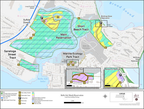
Figure 1. Land Stewardship Zoning Map
DCR Stewardship Map Tool
This RMP should be viewed in conjunction with DCR’s Stewardship Map, a GIS-based tool that allows users to view a property’s natural, cultural, and recreational resources. The Stewardship Map tool is dynamic, and information continues to be updated after adoption of an RMP. Guidance for using the tool, as well as Best Management Practices for resource stewardship, are located on the Stewardship Map site.
Because authorized trails are located within State-Listed Species Habitat on this property, managers should consult an additional GIS-based tool, the NHESP 2022 Guidance Codes for DCR Trail Maintenance Map. This tool allows users to select specific trail segments and identify restrictions and regulatory review associated with performing 10 common trail maintenance activities on these segments. Because site-specific rare species information is confidential under Massachusetts law (M.G.L. c. 66, § 17D), access to this tool is restricted.
Consistency Review
Resource Management Plans “shall ensure consistency between recreation, resource protection, and sustainable forest management” (M.G.L. c. 21, § 2F). For planning purposes, an activity is considered consistent with resource protection if it has no significant, long-term, adverse impact on resources. To this end, a series of indicators were developed to evaluate the impacts of recreation and forest management on natural and cultural resources.
Many activities with the potential to negatively affect resources are already subject to agency and/or regulatory review (e.g., forest management activities, projects within Priority Habitat). For these activities, compliance with state regulations, regulatory authority guidance, DCR policies and processes, and BMPs is considered an indicator of consistency between park use and resource protection. New indicators were generated for activities not subject to agency or regulatory review, and are based on available data, information readily identifiable via aerial imagery or site visits, assessments by DCR subject matter experts, or the property manager’s knowledge of park conditions and use. (See Table 18.)
Indicators are applied during the RMP planning process in order to ensure a standardized assessment of consistency across all properties in the DCR system. Inconsistencies identified via the application of indicators are used to inform the development of management recommendations.
The status of indicators (Yes, No, Unknown, and N/A) were accurate as of 2026 and were used for planning purposes. However, they represent a snapshot in time and may not reflect future conditions. In addition, the status of indicators will change as recommendations get implemented.
Table 18. Consistency Assessment. This assessment represents a snapshot in time and may not reflect future conditions.
| Category | Metric | Status |
|---|---|---|
| Landscape Designation | 1. All development and uses of the park since 2012, or currently planned for the park, are consistent with its Landscape Designation(s). | Yes |
| Natural Resources | 1. All projects (normal maintenance activities, special projects, volunteer projects) conducted within Priority Habitat were reviewed and approved through DCR’s internal review process and by NHESP for potential impacts to rare species and their habitats. | Unknown |
| Natural Resources | 2. All projects conducted within areas subject to state and/or federal wetlands or waterways regulations were reviewed and approved through DCR’s internal review process; reviewed and approved through the appropriate, local, state, and/or federal review process; and were carried out in accordance with the terms of a valid permit. | Yes |
| Natural Resources | 3. Sensitive resource areas, such as steep slopes, riverbanks, streambanks, pond and lakeshores, wetlands, and dunes are free of desire paths and other user-created trails. | No |
| Natural Resources | 4. Aquatic areas adjacent to beaches, boat ramps and launches, roads, and hiking trails are free of eroded sediments. | No |
| Natural Resources | 5. The extent of exposed soil in campground and/or picnic sites is stable or decreasing. | Yes |
| Natural Resources | 6. The extent of native vegetation in campground and/or picnic sites is stable or increasing. (As assessed by property manager.) | Yes |
| Natural Resources | 7. Area of trail impacts in Reserves is less than 50% of total area. (See Naughton (2021) for information on primary area of trail impacts.) | N/A |
| Natural Resources | 8. Congregations of breeding, migratory, or wintering wildlife are protected from disturbance by temporary (e.g., seasonal) restrictions on recreational access. | No |
| Natural Resources | 9. Geocaches, letterboxes, orienteering control locations, and other discovery destinations are located outside sensitive natural resource areas and their locations have been reviewed and approved by park personnel. (As assessed by property manager.) | No |
| Natural Resources | 10. Zone I wellhead protection areas are free of vehicle parking, chemical storage, or concentrated recreation. | N/A |
| Natural Resources | 11. All boat ramps and launches have cleaning stations and/or educational signs and materials on preventing the spread of aquatic invasive organisms. (As assessed by property manager.) | N/A |
| Natural Resources | 12. For each barrier beach there is a current, approved Barrier Beach Management Plan and all beach-related activities are conducted in accordance with this plan. | No |
| Cultural Resources | 1. All maintenance activities and projects with the potential to cause sub-surface disturbance are being reviewed by the DCR archaeologist for potential impacts to archaeological resources. | Yes |
| Cultural Resources | 2. All maintenance activities and projects affecting historic properties (buildings, structures, and landscapes over 50-years-old) are being reviewed by the Office of Cultural Resources to avoid adverse impacts. | Yes |
| Cultural Resources | 3. Historic buildings, structures, and landscapes are being used, maintained, and repaired in a manner that preserves their cultural integrity and conveys their historic significance to park visitors. | Yes |
| Cultural Resources | 4. Recreational activities such as hiking, biking, and boating are not eroding cultural properties such as archaeological sites or historic landscapes through creation of desire lines, rutting in the landscape, damage to historic built features, or excessive scouring (erosion) of coastal and shoreline areas. | Unknown |
| Cultural Resources | 5. Geocaches, letterboxes, and other discovery destinations are located away from sensitive cultural resources, and their locations have been reviewed and approved by park personnel. | No |
| Cultural Resources | 6. Historic buildings, structures, landscapes, archaeological sites, and concentrations of historic resources are located outside of areas predicted to be subject to flooding, storm surge, or sea-level rise. | No |
| Recreation | 1. Types of recreation, levels of recreational use, and types and extent of recreation infrastructure are consistent with the park’s identity statement. | Unknown |
| Recreation | 2. Trail density is consistent with the park’s Landscape Designation(s). (See Trails Guidelines and Best Practices Manual (DCR 2019a) for density thresholds.) | Yes |
| Recreation | 3. All authorized trail construction was performed in accordance with an approved Trail Proposal Form. | Unknown |
| Recreation | 4. Over 90% of the park’s official trails network is classified as being in Fair or better condition. | No |
| Recreation | 5. Recurring use by Off-Highway Vehicles (OHVs) is restricted to authorized trails. (As assessed by property manager.) | N/A |
| Recreation | 6. There is a high level of compliance with dog leash regulations and policies. (As assessed by property manager.) | No |
| Recreation | 7. Athletic fields are free of recreation-caused impacts (e.g., bare spots) to turf. (As assessed by property manager.) | N/A |
| Recreation | 8. Water-based recreation is consistent with “Uses Attained” designation as identified by MassDEP in its most current integrated list of waters (e.g., MassDEP 2023a); Massachusetts Department of Public Health (DPH) fish consumption advisories; and/or water quality testing at waterfront areas. | No |
| Recreation | 9. Recreation facilities are located outside of areas subject to flooding, storm surge, or sea-level rise. | No |
| Sustainable Forest Management | 1. Forestry activities are consistent with Landscape Designation and associated forestry guidelines. | N/A |
| Sustainable Forest Management | 2. Forestry activities are consistent with current Forest Resource Management Plan. | N/A |
| Sustainable Forest Management | 3. Tree cutting is performed in accordance with an approved cutting plan, if required under the Massachusetts Forest Cutting Practices Act (M.G.L. Ch. 132, Sections 40–46). | N/A |
Management Recommendations
Thirty-nine priority management recommendations were developed for this property. They are presented in Table 19. All recommendations are of equal importance and should be implemented as resources allow.
Priority management recommendations derive from Threats, Opportunities, and Consistency Assessment information presented in this RMP. For a recommendation to be considered a priority and listed in the table, it must meet one or more of the criteria listed below. Maintenance and management needs not meeting one or more of these criteria are not included in the table but are identified in the Threats and Opportunities sections.
The following types of recommendations are considered priority:
- Natural resource stewardship and restoration activities consistent with park identity and intended to improve ecological function and connectivity.
- Cultural resource management activities consistent with park identity and intended to prevent the loss of integrity of significant cultural resources.
- Improvements consistent with park identity that are needed to support intended park activities.
- Actions required for regulatory compliance or compliance with legal agreements.
- Activities that prevent or ameliorate threats to the health and safety of park visitors and employees.
- Activities that address inconsistencies among recreation, resource protection, and sustainable forest management, as identified through use of the Consistency Assessment checklist.
Progress toward implementing priority recommendations is tracked through the use of DCR’s Capital Asset Management Information System (CAMIS). The property manager should enter each recommendation listed in Table 19 into CAMIS as a separate work order, noting “*RMP” in the description field. Non-traditional work orders (e.g., volunteer trail work, posting of DPH Fish Consumption Advisory posters, certification of vernal pools) should be closed out by the property manager, once the recommendation has been implemented.
Table 19. Priority Recommendations for Belle Isle Marsh Reservation. All recommendations are of equal importance. When multiple agency parties are responsible for implementing a recommendation, the lead party, or parties, are identified parenthetically in the Implementation column. Property managers should enter these recommendations as work orders in CAMIS to ensure their tracking and implementation.
| Category | Recommendation | Implementation |
|---|---|---|
| Natural Resources | Prepare a Barrier Beach Management Plan for Short Beach (designated Rv-2 and Wn-1) within Belle Isle Marsh Reservation and Winthrop Shores Reservation, in accordance with Guidelines for Barrier Beach Management in Massachusetts (Massachusetts Barrier Beach Task Force 1994). | Office of Natural Resources, Partner |
| Natural Resources | Resolve potential encroachments at Revere Street and Bayou Street in Revere and Palermo Street in East Boston in accordance with Agency-wide guidance and Best Management Practices (DCR 2022b). | Contractor, Management Forestry (Lead), Office of the General Counsel, Park Operations |
| Natural Resources | As appropriate, resume negotiations with the City of Boston to transfer City-owned marsh to DCR. | Land Protection Program (Lead), Office of the General Counsel, Partner |
| Natural Resources | Continue working with the Division of Capital Asset Management and Maintenance to complete the transfer of land owned by the City of Revere to DCR, as legislated (Massachusetts General Court 1996, 2005, 2022). | Land Protection Program, Office of the General Counsel (Lead), Partner |
| Natural Resources | Locate legal instrument such as deed restriction or easement (if one exists) that governs the Town of Winthrop’s sewer crossing of the Short Beach Tract (see Town of Winthrop 2024 and Whitman & Howard 1906: Sheet 22). | Office of the General Counsel |
| Natural Resources | Encourage and collaborate with public and private partners on a Rumney Marshes Area of Critical Environmental Concern (ACEC) Management Plan. | ACEC Program, Office of Natural Resources (Lead) |
| Natural Resources | In consultation with the Natural Heritage & Endangered Species Program (NHESP), prepare a Habitat Management Plan for Reservation areas in Priority Habitat where future marsh restoration efforts will be proposed. | Office of Natural Resources (Lead), Park Operations |
| Natural Resources | Continue project scoping and design planning (underway as of 2026) for small-scale salt marsh restoration and protection of associated saltmarsh sparrow habitat via the Salt Marsh Adaptation & Resiliency Teams (SMARTeams approach). Collaborate with partners to ensure consensus and an aligned approach for best conservation practices and restoration designs. Program funding, permit, and implement restoration. | Contractor, Office of Climate Resiliency, Office of Natural Resources (Lead), Park Operations |
| Natural Resources | Continue and expand agency participation in regional efforts to design, implement, and program funding for salt marsh restoration work, including initiatives that support saltmarsh sparrow habitat restoration. | Office of Climate Resiliency, Office of Natural Resources (Lead), Park Operations |
| Natural Resources | Continue evaluating feasibility of conceptual, catalytic, long-term marsh restoration strategies or alternatives (and protection of associated saltmarsh sparrow habitat) identified in the Belle Isle Marsh Environmental Inventory, Coastal Modeling, and Restoration Assessment (Woods Hole Group, Inc. 2022). | Contractor, Office of Climate Resiliency, Office of Natural Resources (Lead), Park Operations, Partners |
| Natural Resources | Continue invasive plant management in the Reservation by completing permitted invasives plant management; and completing design, permitting and implementation of additional work phases, as needed (SWCA Environmental Consultants 2024). Continue consultations with the Natural Heritage & Endangered Species Program on post-management planning to restore and manage habitat for bird species protected under the Massachusetts Endangered Species Act. Maintain actions as needed. | Contractor, Office of Natural Resources (Lead), Park Operations |
| Natural Resources | Continue ongoing scientific studies of saltmarsh sparrow populations (e.g. banding) to ensure future viability of conservation efforts for this species. | Office of Natural Resources (Co-Lead), Park Operations (Co-Lead) |
| Natural Resources | Continue Louise’s swallow-wort and crownvetch removal in the meadow. | Office of Natural Resources (Co-Lead), Park Operations (Co-Lead) |
| Natural Resources | Assess known and potential impacts from dogs and bicycling to the Reservation’s conservation values (e.g. Massachusetts Endangered Species Act-protected species, water quality, etc.). As appropriate, integrate findings into work of recreational activities working group (see associated Recreation Priority Recommendation). | ACEC Program, Bureau of Ranger Services, Office of Natural Resources (Lead), Park Operations |
| Natural Resources | When and if applicable, partner with the Office of Coastal Zone Management’s (CZM) ResilientCoasts initiative, specifically the Massachusetts Emergency Management Agency’s upcoming study of a statewide buyout program for managed coastal retreat (Executive Office of Energy & Environmental Affairs 2023). Explore using this concept in a pilot program at Belle Isle Marsh as a means to facilitate marsh migration that would protect both the conservation and recreation values of the Reservation. | Land Protection Program (Co-Lead), Office of the General Counsel, Office of Climate Resiliency (Co-Lead) |
| Natural Resources | Continue consultations with the project proponent for the Suffolk Downs Redevelopment Project to avoid and/or mitigate impacts to the Reservation from the project. During Massachusetts Environmental Policy Act (MEPA) review of Phase 4 of the project, revisit agreed-upon avoidance and mitigation measures to determine their efficacy. Revise existing measures, and incorporate new mitigation, into the MEPA permitting review of the Project, as appropriate. | Office of Natural Resources (Lead), Office of the General Counsel |
| Natural Resources | As appropriate, continue consultations with project proponent for Bennington St. to avoid or mitigate any potential negative impacts to the Reservation. | Office of Natural Resources |
| Natural Resources | As appropriate, continue consultations with project proponents for climate adaptation and municipal vulnerability preparedness projects (e.g. at Bennington Street, Morton Street, and Winthrop Parkway and Short Beach) to avoid or mitigate adverse effects that may result to the Reservation and to identify opportunities to enhance staff access during flood events. | Office of Climate Resilience (Lead), Office of Natural Resources |
| Cultural Resources | Conduct an archaeological reconnaissance survey (950 CMR 70) in cooperation with municipal, tribal governments, Indigenous community stakeholders and non-profit partners, including the Cities of Boston and Revere and the Town of Winthrop. Complete appropriate Massachusetts Historical Commission archaeological site forms for identified archaeological resources. As feasible, incorporate geophysical-based data collection methods into the survey to ascertain the potential presence of buried paleo-landscapes that possess archaeological sensitivity. | Consultant, Office of Cultural Resources (Lead), Partners |
| Recreation | Create an updated Reservation trail map. | Interpretive Services (Co-Lead), GIS Office (Co-Lead), Trails & Greenways Section (Co-Lead) |
| Recreation | Install park lead-in signs within and adjacent to the Massachusetts Bay Transportation Authority’s (MBTA) Beachmont and Suffolk Downs stations on the Blue Line. | Park Operations |
| Recreation | Install a permanent Land and Water Conservation Fund acknowledgement sign (NPS 2023). | Park Operations |
| Recreation | Develop and implement a Reservation-wide sign plan to address the threats and opportunities identified in this RMP concerning identification signs, missing rules and regulations signs, Welcome Waysides, Park Watch signs, pet waste signs, and “no biking” and “no e-biking” signs, and access to the Reservation for Environmental Justice communities. | Interpretive Services (Co-Lead), Park Operations (Co-Lead), Senior Director of Environmental Justice (Co-Lead), Sign Shop |
| Recreation | Enforce current Parks and Recreation Rules (302 CMR 12.00) that prohibit electric bikes in the Reservation. (Electric bike enforcement must comply with Americans with Disabilities Act Title II, §35.137 Mobility Devices.) | Bureau of Ranger Services (Co-Lead), Regional Staff (Co-Lead), Park Operations, Universal Access Program |
| Recreation | Create agency working group to examine recreational uses, conflicts, and priorities for the Reservation on topics such as off-leash dogs and cycling. Integrate information concerning impacts of recreation activities on natural resources, as needed (see associated Natural Resources Priority Recommendation). As appropriate, increase education and/or take other measures (e.g. increased enforcement, or rulemaking as allowed under 302 CMR 12.01(f)) to address recreation management issues or threats to natural resources from recreation activities. | ACEC Program, Bureau of Ranger Services (Co-Lead), Interpretive Services, Office of External Affairs and Partnerships, Office of the General Counsel, Office of Natural Resources (Co-Lead), Park Operations (Co-Lead), Partners, Regional Staff |
| Recreation | Complete and implement the interpretive plan for the Reservation. In addition to natural resources programming already in effect, consider as potential topics in the interpretive plan: the marsh’s role in the Battle of Chelsea Creek and the low frequency radio range station. | Interpretive Services (Lead), Park Operations, Office of Cultural Resources, Office of Natural Resources |
| Recreation | Continue to implement Key Recommendations from the 2022 Program Accessibility Assessment (IHCD 2022). Using DCR Project Shade’s Kit of Parts, install shade structures (where appropriate on the Reservation given the sensitive ecosystem) and/or plant additional native canopy trees to enhance visitor and staff safety and comfort. | Landscape Architecture Section (Co-Lead), Contractor, Office of Climate Resilience, Universal Access Program (Co-Lead) |
| Recreation | Repair poorly drained section of Kilmartin Walkway in Winthrop. | Park Operations (Co-Lead), Trails and Greenways Section (Co-Lead) |
| Recreation | Place boundary markers where missing along the perimeter lot lines for all Reservation tracts. | Contractor, Management Forestry (Lead) |
| Recreation | Repair guardrails, and install guardrails where absent, around perimeter of Reservation tracts along public and private roadways. | Contractor, Park Operations |
| Recreation | Enhance Dump Road/Bayou Street frontage and entrance by:
| Contractor, Management Forestry, Park Operations (Co-Lead), Partner, Visitor Services (Co-Lead) |
| Recreation | As appropriate, promote the Massachusetts Executive Office of Energy and Environmental Affairs (EEA’s) Environmental Justice Policy goals at Belle Isle Marsh Reservation. | Land Protection Program (Co-Lead), Senior Director of Environmental Justice (Co-Lead), Trails and Greenways Section (Co-Lead), Interpretive Services (Co-Lead), Partners |
| Recreation | Post Department of Public Health Fish Consumption Advisory Posters at Reservation kiosks and fishing access locations along Belle Isle Inlet. | Park Operations |
| Recreation | In accordance with the DCR Operations and Maintenance Plan for MS4 Permit Compliance (DCR 2023a: 7), install pet waste handling and disposal facilities, including standard regulatory signage, at the entrance to the Marine Ecology Park Tract, as well as any other major reservation entry points where such facilities may be lacking. | Park Operations (Lead), Sign Shop |
| Recreation | Resolve trail-related threats and opportunities identified in this RMP, in accordance with Trails Guidelines and Best Practices (DCR 2019a, or update), through the following actions:
| Management Forestry, Office of Cultural Resources, Office of Natural Resources, Park Operations (Co-Lead), Partners, Trails and Greenways Section (Co-Lead) |
| Recreation | Work with the geocaching community to ensure that caches located in sensitive natural and cultural resources are relocated out of those areas and that locations of any new geocaches are placed outside of sensitive areas and with the approval of the property manager. | Office of Cultural Resources, Office of Natural Resources, Park Operations (Lead) |
| Recreation | Increase the presence of DCR staff, as appropriate and available, in areas of the Reservation with high levels of depreciative behaviors. | Bureau of Ranger Services (Co-Lead), Regional Staff (Co-Lead), Park Operations |
| Recreation | Implement repair program for the observation tower, bridge to the island, and boardwalks using materials that can withstand the coastal climate. Evaluate whether such resources should be programmed for replacement within a capital improvement budget. | Facilities Engineering (Co-Lead), Park Operations (Co-Lead), Trade Operations (Co-Lead) |
| Recreation | Plant new native canopy trees to shade the picnic area as dying ash trees are removed. Utilize species that are appropriate to the existing native Natural Community types and to the Boston Basin and Southern New England Coastal Ecoregion, as well as resilient to potential climate change scenarios. | Forest Health, Landscape Architecture Section, Office of Natural Resources, Partner, Urban and Community Forestry |
References
Plans and Guiding Documents
BSC Group, Inc. (BSC). 2017. Invasive Plant Management Plan: North Region. Produced in association with: DCR Ecology & ACEC Program, June 2017.
Driscoll, D. 1987. Belle Isle Marsh Reservation Site Assessment. MetroParks, Metropolitan District Commission, Boston, MA. January 1987. On file, Report Collection, DCR Archives, Massachusetts State Archives, Boston, MA.
Falk, J., C. Shurcliff, and R. Furniss. 1973. Proposed Belle Isle Reservation. Metropolitan District Commission, Boston, MA. July 1973. Three plan versions on file, DCR Archives, Massachusetts State Archives, Boston, MA.
Furniss, R. and J. Falk. 1973. Proposed Belle Isle Marsh Reservation, Metropolitan District Commission, Boston, MA. Submitted to the Commissioners of the MDC, August 1, 1973. On file, Report Collection, DCR Archives, Massachusetts State Archives, Boston, MA.
Institute for Human Centered Design. 2021. Belle Isle Marsh Reservation, East Boston, MA: Program Accessibility Assessment. Boston, MA. Prepared for the Department of Conservation and Recreation, Boston, MA.
Massachusetts Department of Conservation and Recreation (DCR). 2012a. Landscape designations for DCR parks & forests: Selection criteria and management guidelines. March 2012. Boston, MA.
Massachusetts Department of Conservation and Recreation (DCR). 2012b. Appendix 4. Land Stewardship Zoning Guidelines. Final Update: July 2012. Pages 76-85 In Landscape Designations for DCR Parks and Forests: Selection Criteria and Management Guidelines. March 2012.
Moriece and Gary, Inc. 1978. Belle Isle Marsh Reservation: Preliminary Research and Master Plan Phase, Feasibility Study. Prepared for the Metropolitan District Commission, Boston, MA, by Moriece and Gary, Inc., Landscape Architects, Cambridge, MA. On file, Report Collection, DCR Archives, Massachusetts State Archives, Boston, MA.
Riley, S. 2020. Belle Isle Marsh Reservation, Area of Critical Environmental Concern & Important Bird Area, Management Assessment. Draft management assessment updated 2023. On file, Massachusetts Department of Conservation and Recreation, Boston, MA.
Vernegaard, L. 1987. Belle Isle Marsh Reservation: Management Assessment. Metropolitan District Commission, Boston, MA. October 1987. On file, Report Collection, DCR Archives, Massachusetts State Archives, Boston, MA.
Additional Information
Adamowicz, S., G. Wilson, D. M. Burdick, W. Ferguson, and R. Hopping. 2020. Farmers in the marsh: lessons from history and case studies for the future. Wetland Science & Practice, July 2020: 183–195.
Adams, V., S. P. Berg, I. Matos, C. Riley, E. Maass, T. Orwig, B. Friedberg. 2004. Metropolitan Park System of Greater Boston. National Register of Historic Places Multiple Property Documentation Form. NRIS No. 64500822. National Park Service, Washington, DC.
Alemu, J. B., C. Ofsthun, G. Medley, A. Bowden, A. Cammett, E. Gildesgame, S. E. Munoz, A. Stubbins, A. R. Hughes. Evaluating ecosystem services in urban salt marshes: Assessing vulnerability to sea-level rise and implications for coastal management. Journal of Environmental Management, December 2024.
Arrigo, B. 2023a. Brian Arrigo, Commissioner, Department of Conservation and Recreation; correspondence with Kara Runsten, Manager, EEA Municipal Vulnerability Preparedness Program. May 5, 2023.
Arrigo, B. 2023b. Brian Arrigo, Commissioner, Department of Conservation and Recreation; correspondence with Kara Runsten, Manager, EEA Municipal Vulnerability Preparedness Program. May 4, 2023.
Askew, A. E., and J. M. Bowker. 2018. Impacts of Climate change on outdoor recreation participation: Outlook to 2060. Journal of Park and Recreation Administration 36: 97–120.
Atlantic Coast Joint Venture (ACJV). 2022. Saltmarsh Restoration Priorities for the Saltmarsh Sparrow: Massachusetts.
Bishop, B. and S. Zendeh. 2014. A Natural and Political History of Belle Isle Marsh. Bird Observer 42:3 (2014): 137–151.
Board of Harbor Commissioners. 1877. Eleventh Annual Report of the Board of Harbor Commissioners. House Document No. 25. Albert J. Wright, Boston, MA.
Board of Harbor Commissioners. 1878. Annual Report of the Board of Harbor Commissioners for the Year 1877. Public Document No. 33. Rand, Avery & Co., Boston, MA.
Board of Harbor and Land Commissioners. 1896. Annual Report of the Board of Harbor and Land Commissioners for the Year 1895. Public Document No. 11. Wright & Potter Printing Co., Boston, MA.
Boston Natural Areas Fund. 1991. 1990 Boston Urban Wilds Report.
City of Boston. 2022. Coastal Resilience Solutions for East Boston and Charlestown (Phase II). Final Report, August 2022. Prepared by the City of Boston with Arcadis, Sasaki, Woods Hole Group, One architecture, and Neighborhood of Affordable Housing.
City of Boston Parks and Recreation Department. 1982. Boston Park & Recreation Recovery Action Program. Boston, MA.
City of Boston Parks and Recreation Department. 2015. City of Boston Open Space & Recreation Plan, 2015–2021. City of Boston Parks and Recreation Department, Boston, MA.
City of Boston Parks and Recreation Department. 2023. City of Boston Open Space and Recreation Plan. June. Prepared by the City of Boston Parks and Recreation Department, Boston, MA.
City of Boston Planning and Development Agency. 2024. 1141 Bennington Street.
City of Boston Redevelopment Authority (BRA). 1976. Boston Urban Wilds: A natural area conservation program. BRA, Boston, MA.
City of Boston Redevelopment Authority (BRA). 1977. East Boston district profile & proposed 1978–1980 Neighborhood Improvement Program. City of Boston, Doston Redevelopment Authority Neighborhood Planning Program. Summer, 1977.
City of Boston Redevelopment Authority (BRA). 2020. Phase 1 Development Plan for Planned Development Area No. 124, Suffolk Downs Redevelopment, East Boston. October 28.
Clark, J., Y. Wang, and P. V. August. 2014. Assessing current and projected suitable habitat for tree-of-heaven along the Appalachian Trail. Philosophical Transactions of the Royal Society B 369: 20130192.
Clark, W. H. 1952. The History of Winthrop, Massachusetts, 1630–1952. Winthrop Centennial Committee, Winthrop, MA.
Comeau, J. 2017. Memorandum, J. Comeau to DCR Lands Committee. July 10. Department of Conservation and Recreation, Boston, MA.
Commonwealth of Massachusetts. 2023. ResilientMass Plan: 2023 Massachusetts State Hazard Mitigation and Climate Adaptation Plan. ResilientMass Action Team, Boston, Massachusetts.
Commonwealth of Massachusetts and Woods Hole Group, Inc. (WHG). 2021. Massachusetts Coast Flood Risk Model (MC-FRM). Prepared by WHG for the Commonwealth of Massachusetts. Massachusetts Office of Coastal Zone Management (CZM) Sea Level Rise and Coastal Flooding Viewer.
Coxe, Trudy. 1996. Policy Guidelines for the Review and Approval of ACEC Resource Management Plans. Secretary of the Executive Office of Energy and Environmental Affairs, Boston, MA. March 15, 1996.
Dukes, J. S., J. Pontius, D. Orwig, J. R. Garnas, V. L. Rodgers, N. Brazee, B. Cooke, K. A Theoharides, E. E. Stange, R. Harrington, J. Ehrenfeld, J. Gurevitch, M. Lerdau, K. Stinson, R. Wick, and M. Ayres. 2009. Responses of insect pests, pathogens, and invasive plant species to climate change in the forests of northeastern North America: What can we predict? Canadian Journal of Forest Research 39: 231–248.
eBird. 2025. Belle Isle Marsh Reservation – Sightings.
Eller, F., H. Skalova, J. S. Caplan, G. P. Bhattarai, M. L. Burger, J. T. Cronin, W-Y. Guo, X. Guo, E. L. G. Hazelton, K. M. Kettenring, C. Lambertini, M. K. McCormick, L. A. Meyerson, T. J. Mozdzer, P. Pysek, B.K. Sorrell, D. F. Whigman, and H. Brix. 2017. Cosmopolitan species as models for ecophysiological responses to global change: The common reed Phragmites australis. Frontiers in Plant Science Volume 8-2017.
Environmental Protection Agency (EPA). 2010. Consent Decree: City of Revere, Massachusetts: Civil Action No. 1:10-cv-11460.
Federal Aviation Administration (FAA). 2020. Advisory Circular: Hazardous Wildlife Attractants on or near Airports. AC No. 150/5200-33C. February 21. US Department of Transportation, Federal Aviation Administration, Washington, DC.
Federal Aviation Administration (FAA). 2026. Part 77—Safe, efficient use, and preservation of the navigable airspace. Published in the National Archives and Records Administration Code of Federal Regulations.
Finch, D. M., J. L. Bitler, J. B. Runyon, C. J. Fettig, F. F. Kilkenny, S. Jose, S. J. Frankel, S. A. Cushman, R. C. Cobb, J. S. Dukes, J. A. Hicke, and S. K. Amelon. 2021. Effects of Climate Change on invasive species. Chapter 4 in T. M. Poland, T. Patel-Weynand, D. M. Finch, C. F. Miniat, D. C. Hayes, and V. M. Lopes (Editors) Invasive species in forests and rangelands of the United States: A comprehensive science synthesis for the United States forest sector. Springer.
Friends of Belle Isle Marsh (FBIM). 1983. Sales Creek. Belle Isle News, February 1983: n. p.
Friends of Belle Isle Marsh (FBIM). 2015. Marine Ecology Park Planned. Belle Isle News, March 2015: 8.
Friends of Belle Isle Marsh (FBIM). 2023. History.
Friends of the Mary Ellen Welch Greenway. 2023. Greenway Extensions.
Friggens, M. M., M. I. Williams, K. E. Bagne, T. T. Wixom, and S. A. Cushman. 2018. Effects of climate change on terrestrial animals. Pages 264–315 in Halofsky, J. E., D. L. Peterson, J. J. Ho, N. J. Little, and L. A. Joyce (Eds.). Climate change vulnerability and adaptation in the Intermountain Region. Gen. Tech. Rep. RMRS-GTR-375. Fort Collins, CO: U.S. Department of Agriculture, Forest Service, Rocky Mountain Research Station. Part 2. pp. 199–513.
Gard, B. A. 1984. Belle Isle: A salt marsh in a city. A thesis submitted by Barbara A. Gard in partial fulfillment of the requirements for the degree of Master of Arts in Urban and Environmental Policy, Tufts University, October 1984. On file, Report Collection, DCR Archives, Massachusetts State Archives, Boston, MA.
Google. n.d. Belle Isle Marsh Reservation. Reviews.
Halofsky, J. E., D. L. Peterson, J. J. Ho, N. J. Little, and L. A. Joyce (Eds.). 2018. Climate change vulnerability and adaptation in the Intermountain Region. Gen. Tech. Rep. RMRS-GTR-375. Fort Collins, CO: U.S. Department of Agriculture, Forest Service, Rocky Mountain Research Station. Part 2. pp. 199–513.
Ham, S. H. 2013. Interpretation: Making a difference on purpose. Fulcrum Publishing, Golden, CO.
Harris, J. 2023. J. Harris, DCR Office of Cultural Resources; email communication with J. Daly, DCR Resource Management Plan staff.
Intergovernmental Panel on Climate Change (IPCC). 2021. Annex VII: Glossary [Matthews, J.B.R., V. Möller, R. van Diemen, J.S. Fuglestvedt, V. Masson-Delmotte, C. Méndez, S. Semenov, A. Reisinger (eds.)]. In Climate Change 2021: The Physical Science Basis. Contribution of Working Group I to the Sixth Assessment Report of the Intergovernmental Panel on Climate Change [Masson-Delmotte, V., P. Zhai, A. Pirani, S.L. Connors, C. Péan, S. Berger, N. Caud, Y. Chen, L. Goldfarb, M.I. Gomis, M. Huang, K. Leitzell, E. Lonnoy, J.B.R. Matthews, T.K. Maycock, T. Waterfield, O. Yelekçi, R. Yu, and B. Zhou (eds.)]. Cambridge University Press, Cambridge, United Kingdom and New York, NY, USA, pp. 2215–2256, doi:10.1017/9781009157896.022.
International Council on Monuments and Sites (ICOMOS) Climate Change and Cultural Heritage Working Group. 2019. The Future of our Pasts: Engaging Cultural Heritage in Climate Action. ICOMOS, Paris, France.
Isaak, D. J., M. K. Young, C. Tait, D. Duffield, D. L. Horan, D. E. Nagel, and M. C. Groce. 2018. Effects of climate change on native fish and other aquatic species. Pages 89–111 in Halofsky, J. E., D. L. Peterson, J. J. Ho, N. J. Little, and L. A. Joyce (Eds.). Climate change vulnerability and adaptation in the Intermountain Region. Gen. Tech. Rep. RMRS-GTR-375. Fort Collins, CO: U.S. Department of Agriculture, Forest Service, Rocky Mountain Research Station. Part 1. Pp. 1–197.
Janowiak, M. K., A. W. D’Amato, C. W. Swanston, L. Iverson, F. R. Thompson, III, W. D. Dijak, S. Matthews, M. P. Peters, A. Prasad, J. S. Fraser, L. A. Brandt, M. J. Butler-Leopold, S. D. Handler, P. D. Shannon, D. Burbank, J. Campbell, C. Cogbill, M. J. Duveneck, M. R. Emery, N. Fisichelli, J. Foster, J. Hushaw, L. Kenefic, A. Mahaffey, T. L. Morelli, N. J. Reo, P. G. Schaberg, K. R. Simmons, A. Weiskittel, S. Wilmot, D. Hollinger, E. Lane, L. Rustad, and P. H. Templer. 2018. New England and northern New York ecosystem vulnerability assessment and synthesis: A report from the New England Climate Change Response Framework project. Gen. Tech. Rep.NRS-173. Newtown Square, PA: U.S. Department of Agriculture, Forest Service, Northern Research Station. 234 p.
Kendall Media, Inc. n.d. Belle Isle Marsh Reservation. BringFido.com.
Kernan, E. M. and S. Riley. 2023. Demographics of Saltmarsh Sparrows at Belle Isle Marsh Reservation, Boston. Bird Observer: The New England Birding Journal 51:4 (August).
King, E. J. 1980. Executive Order No. 181: Barrier beaches.
Kliejunas, J. T., B. W. Geils, J. M. Glaeser, E. M. Goheen, P. Hennon, M.-S. Kim, H. Kope, J. Stone, R. Sturrock, and S. J. Frankel. 2009. Review of literature on climate change and forest diseases of western North America. Gen. Tech. Rep. PSW-GTR-225. Albany, CA: U.S. Department of Agriculture, Forest Service, Pacific Southwest Station.
Leddick, J. 2025. Re: Draft Belle Isle Marsh Reservation Resource Management Plan. Massachusetts Division of Fisheries and Wildlife, correspondence with Paul Cavanagh, Department of Conservation and Recreation. June 25, 2025.
Liu, Y., A. M. O. Odour, Z. Zhang, A. Manea, I. M. Tooth, M. R. Leishman, X. Xu, and M. Van Kleunen. 2017. Do invasive alien plants benefit more from global environmental change than native plants? Global Change Biology (2017), doi: 10.1111/gcb.13579.
Manomet Center for Conservation Sciences & Massachusetts Division of Fisheries and Wildlife. 2010. Climate change and Massachusetts fish and wildlife: volume 2, habitat and species vulnerability.
Massachusetts Barrier Beach Task Force. 1994. Guidelines for Barrier Beach Management in Massachusetts. A report of the Massachusetts Barrier Beach Task Force, published by the Massachusetts Office of Coastal Zone Management, Boston, MA.
Massachusetts Bays National Estuary Partnership (MassBays). 2023a. A blueprint for the bays: comprehensive conservation and management plan, 2023–2023. Submitted to the US Environmental Protection Agency, February 5 by MassBays, Boston, MA.
Massachusetts Bays National Estuary Partnership (MassBays). 2023b. Massachusetts Bays National Estuary Partnership, Long-Term Plan for Bipartisan Infrastructure Law Expenditures. MassBays, Boston, MA.
Massachusetts Bays National Estuary Partnership (MassBays). 2023c. Healthy Estuaries Grant Program.
Massachusetts Bureau of Geographic Information (MassGIS). 2003. MassGIS Data: Priority Natural Vegetation Communities. April 2003.
Massachusetts Bureau of Geographic Information (MassGIS). 2017. MassGIS Data: MassDEP Wetlands (2005). December 2017.
Massachusetts Bureau of Geographic Information (MassGIS). 2023. FEMA National Flood Hazard Layer. July 2023.
Massachusetts Department of Conservation and Recreation (DCR). 2004. Areas of Critical Environmental Concern Resource Management Plan guidelines. Ecology & Area of Critical Environmental Concern Program, Boston, MA. June 2004.
Massachusetts Department of Conservation and Recreation (DCR). 2017. ACEC guide to state regulations and programs.
Massachusetts Department of Conservation and Recreation (DCR). 2019. Trails guidelines and best practices manual. Updated July 2019.
Massachusetts Department of Conservation and Recreation (DCR). 2020. Massachusetts State Forest Action Plan 2020. Executive Office of Energy & Environmental Affairs, Department of Conservation and Recreation, Massachusetts Bureau of Forest Fire Control and Forestry.
Massachusetts Department of Conservation and Recreation (DCR). 2022a. Manual for Continuous Forest Inventory field procedures. Bureau of Forestry, Division of State Parks and Recreation. Rev. March 2022.
Massachusetts Department of Conservation and Recreation (DCR). 2022b. Encroachments. Massachusetts Department of Conservation and Recreation, Agency-wide guidance and best management practices. Version 1.1 Approved BMP, 011922.
Massachusetts Department of Conservation and Recreation (DCR). 2023a. DCR operations and Maintenance (O+M) Plan for MS4 Permit Compliance. June 30, 2020; revised June 30, 2023.
Massachusetts Department of Conservation and Recreation (DCR). 2023b. Managing our forests…for carbon benefits.
Massachusetts Department of Conservation and Recreation (DCR). 2024. DCR Climate Impacts. Story Map series highlighting the expected impacts caused by climate change across the DCR’s facilities and operations in Massachusetts.
Massachusetts Department of Environmental Protection (MassDEP). 2023a. Final Massachusetts integrated list of waters for the Clean Water Act 2022 Reporting Cycle. CN. 568.1. May 2023. Prepared by: Watershed Planning Program, Division of Watershed Management, Bureau of Water Resources.
Massachusetts Department of Environmental Protection (MassDEP). 2023b. Final Massachusetts integrated list of waters for the Clean Water Act 2022 Reporting Cycle: Appendix 6, Boston Harbor: Mystic River basin and coastal drainage area Assessment and Listing Decision Summary. CN. 568.1. Prepared by: Watershed Planning Program, Division of Watershed Management, Bureau of Water Resources.
Massachusetts Department of Environmental Protection (MassDEP), US Environmental Protection Agency (USEPA) New England Region 1, and ENSR International (now AECOM). 2018. Final Pathogen Total Maximum Daily Load for the Boston Harbor, Weymouth-Weir, and Mystic Watersheds, October 2018. CN 157.1. Prepared as a cooperative effort by the Massachusetts DEP, Boston, MA; USEPA, Boston, MA; and ENSR International, Westford, MA.
Massachusetts Department of Natural Resources (DNR). 1964. Resolve No. 855. Report of the Department of Natural Resources relative to coastal wetlands in the Commonwealth under Chapter 15 of the Resolves of 1963. January 1964.
Massachusetts Department of Public Works. 1936. Sixteenth Annual Report of the Department of Public Works, Year ending November 20, 1935. Public Document No. 54. Boston, MA.
Massachusetts Department of Transportation (MassDOT). 2023. MassDOT Project Development and Design Guide. October 2023.
Massachusetts Department of Transportation (MassDOT). 2024. Massachusetts Priority Trails Network Vision Map.
Massachusetts Division of Fisheries and Wildlife (MassWildlife). 2015. Massachusetts State Wildlife Action Plan 2015. Westborough, MA.
Massachusetts Division of Fisheries and Wildlife (MassWildlife). 2023a. Living with wildlife: Eastern coyotes in Massachusetts. MassWildlife, Boston, MA.
Massachusetts Division of Fisheries and Wildlife (MassWildlife). 2023b. Understanding coyotes: Advice for parents, school officials, and childcare providers. MassWildlife, Boston, MA.
Massachusetts Executive Office of Energy and Environmental Affairs (EEA). 2021. Environmental Justice Policy of the Executive Office of Energy and Environmental Affairs. Updated June 24, 2021.
Massachusetts Executive Office of Energy and Environmental Affairs (EEA). 2022. 2022 Massachusetts Climate Change Assessment, Volume II – Statewide Report. Executive Office of Energy and Environmental Affairs, Boston, MA.
Massachusetts Executive Office of Energy and Environmental Affairs (EEA). 2023. Press release: Healy-Driscoll Administration launches statewide coastal resiliency strategy. November 28. EEA, Boston, MA.
Massachusetts Executive Office of Energy and Environmental Affairs (EEA). 2024. Response to the report of the Climate Forestry Committee.
Massachusetts Executive Office of Housing and Economic Development. 2017. Baker-Polito Administration breaks ground at Belle Isle Marsh Marine Ecology Park.
Massachusetts General Court (MGC). 1963. Chapter 426 of the Acts of 1963. An act regulating the removal, filling and dredging of certain areas bordering on the coastal waters of the Commonwealth.
Massachusetts General Court (MGC). 1964. Chapter 167 of the Acts of 1964. An act prohibiting the dumping of garbage in so much of the marshland adjoining Belle Isle Inlet as lies in the cities of Boston and Revere.
Massachusetts General Court (MGC). 1970. Chapter 725 of the Acts of 1970. An act to provide for a recreation program for the Metropolitan Parks District.
Massachusetts General Court (MGC). 1971. Chapter 976 of the Acts of 1971. An act to provide for a capital outlay program for the Commonwealth.
Massachusetts General Court (MGC). 1976. Chapter 481 of the Acts of 1976. An act providing for a capital outlay program for the Commonwealth.
Massachusetts General Court (MGC). 1996. Chapter 351 of the Acts of 1996. An act authorizing and directing the division of capital planning and operations to convey a certain parcel of land in the City of Revere to the City of Revere for public safety purposes or recreational purposes.
Massachusetts General Court (MGC). 2003. Chapter 449. An act establishing a citizens advisory board on uses of the Rumney Marsh Area.
Massachusetts General Court (MGC). 2005. Chapter 154 of the Acts of 2005. An act authorizing the conveyance of a certain parcel of Commonwealth land to the City of Revere for public purposes.
Massachusetts General Court (MGC). 2010. An act designating a proposed walking path in the Belle Isle Marsh Area in the Town of Winthrop as the John Kilmartin Walkway.
Massachusetts General Court (MGC). 2022. Chapter 151 of the Acts of 2022. An act authorizing the transfer of certain land of the Commonwealth to the City of Revere for municipal purposes.
Massachusetts Historical Commission (MHC). 1981a. MHC Reconnaissance Survey Town Report: Revere. Massachusetts Historical Commission, Boston, MA.
Massachusetts Historical Commission (MHC). 1981b. MHC Reconnaissance Survey Town Report: Winthrop. Massachusetts Historical Commission, Boston, MA.
Massachusetts Invasive Plant Advisory Group (MIPAG). 2024. Plants voted as: Invasive.
Massachusetts Metropolitan District Commission (MDC) and the Massachusetts Port Authority. 1979. Agreement between the MDC and the Massachusetts Port Authority dated June 28, 1979. Suffolk County Registry of Deeds, Registered Land, Document number 346687.
Massachusetts Office of Coastal Zone Management (CZM). 2011. Massachusetts Coastal Program Policies.
Massachusetts Office of Coastal Zone Management (CZM). 2023. Barrier Beach Management in Massachusetts.
Massachusetts Water Resources Authority (MWRA). 2006. Massachusetts Water Resources Authority Wastewater System Master Plan. Massachusetts Water Resources Authority, Boston, MA.
Massachusetts Wetland Restoration Program and Massachusetts Department of Environmental Management. 2002. Rumney Marshes Area of Critical Environmental Concern: Salt Marsh Restoration Plan. Prepared on behalf of the Rumney Marshes ACEC Salt Marsh Restoration Task Group by the Massachusetts Wetland Restoration Program, Boston, MA, and Massachusetts Department of Environmental Management, Boston, MA.
Mastone, V. T., C. Brown, C. Maio. 2011. Chelsea Creek—First naval engagement of the American Revolution: Chelsea, East Boston, Revere, and Winthrop. Final Technical Report, December. Prepared under National Battlefield Protection Program Grant Agreement No. GA-255-09-018.
McNab, W. H., and D. L. Loftis. 2002. Probability of occurrence and habitat features for oriental bittersweet in an oak forest in the southern Appalachian Mountains, USA. Forest Ecology and Management 155(2002): 45–54.
Merow, C., S. T. Bois, J. N. Allen, Y. Xie, and J. A. Silander, Jr. 2017. Climate change both facilitates and inhibits invasive plant ranges in New England. Proceedings of the National Academy of Sciences E3276–E3284.
Metropolitan Area Planning Council (MAPC). 2011. Walk Winthrop: A greenway action plan. Prepared for the Town of Winthrop by the Metropolitan Area Planning Council, Boston, MA.
Metropolitan Area Planning Council (MAPC). 2014. Town of Winthrop Open Space and Recreation Plan: 2014-2021. Prepared for the Town of Winthrop, Massachusetts, by the Metropolitan Area Planning Council, Boston, MA.
Metropolitan Area Planning Council (MAPC). 2018. Revere Open Space & Recreation Plan, 2018–2025 Update. June. Prepared for the City of Revere Department of Planning and Community Development, Revere, MA, by the Metropolitan Area Planning Council, Boston, MA.
Mitchell, J. H. 2008. A paradise of all these parts: a natural history of Boston. Beacon Press, Boston, MA.
Montgomery, J. 2020. Jim Montgomery, Acting Commissioner of the DCR; correspondence with Secretary Kathleen A. Theoharides, EEA; January 23, 2020.
Mueller, K. 2013. Boston area’s best dog walking trails. CBS News Boston. September 6, 2013.
Mystic River Watershed Association (MyRWA). 2022. Wicked hot Mystic case study. Published by the Museum of Science, Boston, MA.
National Oceanic and Atmospheric Administration (NOAA). 2022. Hurricane Surge. June 2022. Massachusetts Office of Coastal Zone Management (CZM) Sea Level Rise and Coastal Flooding Viewer.
National Park Service (NPS). 1998. Planning for interpretation and visitor experience. Prepared by the Division of Interpretive Planning, Harpers Ferry Center, Harpers Ferry, WV. 1998.
National Park Service (NPS). 2023. Land and Water Conservation Fund State Assistance Program. Federal Financial Assistance Manual. Volume 72. Effective October 1, 2023.
Natural Heritage & Endangered Species Program (NHESP). 2023. Changes to the list of Endangered, Threatened & Special Concern species. NHESP, Boston, MA.
Natural Heritage & Endangered Species Program (NHESP). 2025. Saltmarsh sparrow. Natural Heritage & Endangered Species Program, Division of Fisheries & Wildlife.
Naughton, M. 2021. Wildlife and recreation: Understanding and managing the effects of trail use on wildlife. Prepared for Vermont Fish and Wildlife and Vermont Forests, Parks, and Recreation. November 2021.
O’Toole, D., L. A. Brandt, M. K. Janowiak, K. M. Schmitt, P. D. Shannon, P. R. Leopold, S.D. Handler, T. A. Ontl, and C. W. Swanston. 2019. Climate adaptation strategies and approaches for outdoor recreation. Sustainability 2019, 11, 7030.
Patrick, D. L. 2014. Executive Order No. 552. Executive Order on Environmental Justice.
Reddit. 2021. Belle Isle Marsh.
Riley, S. 2023. Saltmarsh Sparrow Banding and Data Collection at Belle Isle Marsh 2022. January 5, 2023.
Rockman, M., M. Morgan, S. Ziaja, G. Hambrecht, and A. Meadow. 2016. Cultural Resources Climate Change Strategy. National Park Service, Cultural Resources, Partnerships, and Science and Climate Change Response Program, Washington, D.C.
Running the Pack. 2009. Belle Isle Marsh Reservation. Posted May 28, 2009 by Jana.
Rustad, L., J. Campbell, J. S. Dukes, T. Huntington, K, F. Lambert, J. Mohan, and N. Rodenhouse. 2012. Changing climate, changing forests: The impacts of climate change on forests of the northeastern United States and eastern Canada. Gen. Tech. Rep. NRS-99. Newtown Square, PA: U.S. Department of Agriculture, Forest Service, Northern Research Station.
Seasholes, N. S. 2003. Gaining ground: a history of landmaking in Boston. The MIT Press, Cambridge, MA.
Secretary of Environmental Affairs. 1988. Designation of the Rumney Marshes Area of Critical Environmental Concern. Executive office of Environmental Affairs, designated August 22, 1988.
Sperry, K. and R. Hughes. 2023. Research Application: Spartina alterniflora phenotypic and genetic variation across the salt marsh elevational gradient. On file, Massachusetts Department of Conservation and Recreation, Bureau of Resource Protection, Boston, MA.
State Reclamation Board. 1931. Special Report of the State Reclamation Board Relative to Draining Certain Marsh Lands in Lynn, Revere and Saugus for Abatement of the Mosquito Nuisance. House Bill 1310. Commonwealth of Massachusetts, House of Representatives, Boston, MA.
State Reclamation Board. 1932. Report of the State Reclamation Board. In Annual Report of the Commissioner of Agriculture for the Year Ending November 30, 1932. Public Document No. 123. Boston, MA.
Stone, C. S. 1971. An investigation of the Belle Isle Salt Marsh. Prepared for the Boston Conservation Commission, September–December 1971. Photocopy on file, Report Collection, DCR Archives, Massachusetts State Archives, Boston, MA.
Sturrock, R. N., S. J. Frankel, A. V. Brown, P. E. Hennon, J. T. Kliejunas, K. J. Lewis, J. J. Worrall, and A. J. Woods. 2011. Climate change and forest disease. Plant Pathology (2011) 60, 133–149.
Swain, P. 2020. Classification of the natural communities of Massachusetts. Massachusetts Natural Heritage & Endangered Species Program. Massachusetts Division of Fisheries and Wildlife. Westborough, MA.
Swanston, C. W., M. K. Janowiak, L. A. Brandt, P. R. Butler, S. D. Handler, P. D. Shannon, A. Derby Lewis, K. Hall, R. T. Fahey, L. Scott, A. Kerber, J. W. Miesbauer, L. Darling, L. Parker, and M. St. Pierre. 2016. Forest adaptation resources: Climate change tools and approaches for land managers, 2nd ed. Gen. Tech. Rep. NRS-GTR-87-2. U.S. Department of Agriculture, Forest Service, Northeast Research Station. Newtown Square, PA.
SWCA Environmental Consultants. 2024. Notice of Intent: Belle Isle Marsh Invasive Plant and Habitat Management, Boston, Massachusetts. March 2024. Prepared for the Massachusetts Department of Conservation and Recreation, Boston, MA, by SWCA Environmental Consultants, Amherst, MA.
Town of Winthrop. n.d. Belle Isle Marsh Marine Ecology Park.
Town of Winthrop. 2024. Winthrop, MA GIS: Public Works Map Layer.
Town of Winthrop, Massachusetts Office of Coastal Zone Management, Stantec, and Woods Hole Group. 2017. Resilient Winthrop: Designing Coastal Community Infrastructure for Climate Change. Town of Winthrop, MA.
United Nations Educational, Scientific and Cultural Organization (UNESCO) World Heritage Center. 2007. Climate Change and World Heritage. Report on predicting and managing the impacts of climate change on World Heritage and strategy to assist States parties to implement appropriate management responses. World Heritage Reports 22. UNESCO World Heritage Center, Paris, France.
U.S. Army Corps of Engineers (USACE) Engineering with Nature. n.d. Engineering with Nature Project Fact Sheet: Application of Engineering with Nature to enhance urban marsh resiliency, biodiversity, and habitat. U.S. Army Corps of Engineers, Engineer Research & Development Center, Environmental Laboratory.
U.S. Army Corps of Engineers (USACE) Engineering with Nature. 2023. Engineering with Nature to enhance urban marsh resiliency, biodiversity, and habitat. Belle Isle collaborative meeting, April 25, 2023. U.S. Army Corps of Engineers, Engineer Research & Development Center, Environmental Laboratory.
U.S. Army Corps of Engineers (USACE) Engineering with Nature. 2024. Active research project: Engineering with Nature to enhance urban marsh resiliency, biodiversity, and habitat. U.S. Army Corps of Engineers, Engineer Research & Development Center, Environmental Laboratory.
U.S. District Court, District of Massachusetts. 2023. First Modification to 2010 Consent Decree. Civil Action No.: 1:10-cv-11460. Boston, MA.
U.S. Fish & Wildlife Service (USFWS). 2024a. Saltmarsh Sparrow.
U.S. Fish & Wildlife Service (USFWS). 2024b. ACJV Priorities for Saltmarsh Sparrow.
VHB. 2022. DCR Stormwater Design Handbook. October 19, 2022. Prepared for the Massachusetts Department of Conservation and Recreation.
Weston and Sampson. 2022. Climate change vulnerability assessment. September 2022. Report prepared for Massachusetts Department of Conservation and Recreation.
Weston & Sampson. 2023. Project Development Report: Mary Ellen Welch Greenway, Winthrop Extension. Prepared by Weston & Sampson on behalf of the Town of Winthrop, the Mystic River Watershed Association, Friends of Mary Ellen Welch Greenway, Bike Winthrop, and Friends of Belle Isle Marsh.
Whitman & Howard. 1906. Atlas of the towns of Revere and Winthrop, Suffolk County, Massachusetts. Whitman & Howard, Boston, MA.
Wilkins, E. J., and L. Horne. 2024. Effects and perceptions of weather, climate, and climate change on outdoor recreation and nature-based tourism in the United States: A systematic review. PLOS Climate 3(4): e0000266.
Wobus, C., E. E. Small, H. Hosterman, D. Mills, M. Rissing, R. Jones, M. Duckworth, R. Hall, J. Creason, and J. Martinich. 2017. Projected climate change impacts on skiing and snowmobiling in the United States. Global Environmental Change. 45(2017) 1–14.
Woods Hole Group, Inc. (WHG). 2022a. Belle Isle Marsh Environmental Inventory, Coastal Modeling, and Restoration Assessment. December. Prepared for the Mystic River Watershed Association, Arlington, MA, by WHG, Bourne, MA.
Woods Hole Group, Inc. (WHG). 2022b. Sea level rise affecting marsh migration (SLAMM). February 4. Task 4 of WHG, Belle Isle Marsh Environmental Inventory, Coastal Modeling, and Restoration Assessment (December 2022).
Woods Hole Group, Inc. (WHG). 2023. Belle Isle Marsh Climate Vulnerability Assessment. Prepared for the Town of Winthrop, Winthrop, MA, and the Mystic River Watershed Association, Arlington, MA, by WHG, Bourne, MA.
Woods Hole Group, Inc. (WHG). 2024. Belle Isle Marsh Winthrop Parkway & Short Beach Resilience Feasibility Study. November 2024. Prepared for Mystic River Watershed Association, Arlington, MA, by WHG, Bourne, MA.
Zipcar. 2022. The best dog-friendly places to escape with your furry friend in these cities. Ziptopia blog. September 6, 2022.
| Date published: | May 13, 2026 |
|---|