Downloads
Statewide data
Downloads include statewide soils "top 20" polygons, special features (lines and points), and soil survey areas polygons, plus ArcGIS layer files for use in ArcGIS Pro and ArcMap 10.4+. All data are in the NAD83 Mass. State Plane Meters (2001) coordinate system.
By soil survey area
Visit the Web Soil Survey to download data (features and full set of related tables), by soil survey area, directly from the NRCS. Data from the WSS are required for use in the Soils Data Viewer extension in ArcMap and are in the USA Contiguous Albers Equal Area Conic USGS version, WKID 102039 spatial reference.
Overview

The Soils datalayer has been automated from published soils surveys as provided on various media by the United States Department of Agriculture (USDA) Natural Resources Conservation Service (NRCS). All soils data released by MassGIS have been "SSURGO-certified," which means they have been reviewed and approved by the NRCS and meet all standards and requirements for inclusion in the national SSURGO (Soil Survey Geographic database) release of county-level digital soils data. Soil survey areas are roughly based on county boundaries.

The SSURGO-certified soils dataset is generally the most detailed level of soil geographic data developed by the National Cooperative Soil Survey. The information was prepared by digitizing maps, by compiling information onto a planimetric correct base and digitizing, or by revising digitized maps using remotely sensed and other information. The data include a detailed, field verified inventory of soils and miscellaneous areas that normally occur in a repeatable pattern on the landscape and that can be cartographically shown at the scale mapped. Data for survey areas were developed using various scale base maps: some areas at a 1:25,000 or 1:12,000 scale, or at larger scales where source materials (e.g. 1:5,000 MassGIS ortho imagery) were available. Details for a specific survey area are provided in the NRCS-produced metadata that are distributed with the spatial data.
The soil map units are linked to attributes in the National Soil Information System (NASIS) relational database, which gives the proportionate extent of the component soils and their properties.
The state NRCS (via GIS staff at the state Department of Agricultural Resources) delivered a full set of data to MassGIS. MassGIS stores the soils data as statewide layers and tables in an enterprise geodatabase as follows:
GISDATA Schema
The GISDATA schema contains a subset of data for use in MassMapper and desktop software:
- SOILS_MUPOLYGON_TOP20 - To provide a simple, statewide soils data layer, the Massachusetts “Top 20” soils data layer is a statewide polygon feature class of the soil survey data that contains a single set of attributes for each soil survey map unit. The attributes provided are those soil properties or ratings that are most requested by soil survey users through the Web Soil Survey platform.
See the Massachusetts ‘Top-20’ SSURGO Soils Data Layer (.docx format) document for more details.
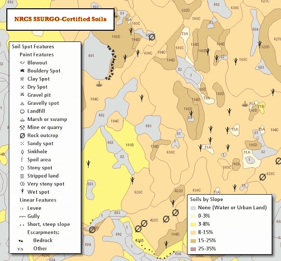
- SOILS_SPECFEAT_ARC (lines) and SOILS_SPECFEAT_PT (points) - "Special" or "ad hoc" features such as gravel pits, wet areas, bedrock escarpments and others. These layers display the location of features too small to delineate at the mapping scale, but they are large enough and contrasting enough to significantly influence use and management.
- SOILS_POLY_PRIMEFARMLAND - A spatial view based on the FRMLNDCLS field in the SOILS_MUPOLYGON_TOP20 feature class.
- SOILS_SURVEY_AREAS_POLY – Index for the 19 soil survey project areas.
For the GISDATA feature classes, MassGIS projected the data into the Massachusetts NAD 1983 State Plane Meters (FIPSZONE 2001) spatial reference.
SOILS Schema
The SOILS schema stores the full set of feature classes and related tables as delivered to MassGIS.
Feature classes (in the USA Contiguous Albers Equal Area Conic USGS version, WKID 102039 spatial reference) and tables include:
- MUPOLYGON – Soils polygons
- MUPOLYGON_TOP20 – Soils polygons with “top 20” attributes as described below
- FEATLINE - Special soil features that are delineated as one or more lines
- FEATPOINT - Special soil features that are delineated as one or more points
- SAPOLYGON – Soil area index
- 71 tables – Tabular data that may be linked to the feature classes, many via relationship classes inside the geodatabase. Some tables provide metadata on tables and columns in the database. The MDSTATTABS (Table Static Metadata) table records metadata about the tables that make up the tabular data set.
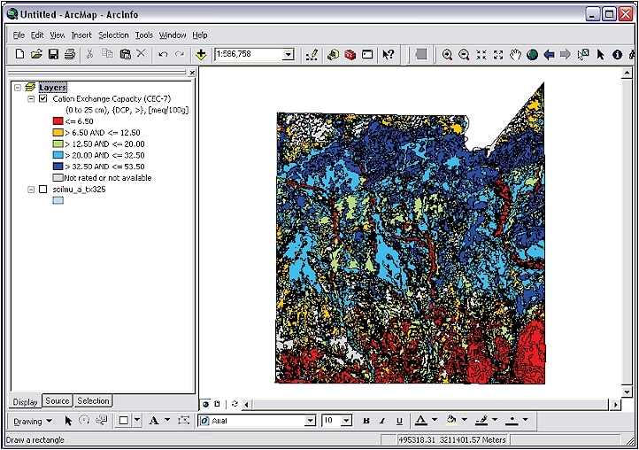
- MapUnitRaster_10m – This image (raster) layer represents the soil map unit polygons in a raster format. Raster layers tend to display much more quickly and lend themselves to certain types of modeling with other raster layers such as landcover, landuse or elevation. Each cell value is represented by the integer version of the mapunit key (MUKEY). The standard character mapunit key (MUKEY) is also included so that the raster attribute table can be joined to other soil attribute tables.
Please see the SSURGO/STATSGO2 Structural Metadata and Documentation page for documents, diagrams, and reports that describe the SSURGO standard.
Attribution
Maps that use NRCS SSURGO data must show the source (NRCS) and date and, space permitting, contain the following notation:
"This Soil Survey Geographic (SSURGO) data base was produced by the U.S. Department of Agriculture, Natural Resources Conservation Service and cooperating agencies for the Soil Survey of _______ County, (state). The soils were mapped at a scale of ______ with a _______ acre minimum size delineation. Enlargement of these maps to scales greater than that at which they were originally mapped can cause misunderstanding of the detail of mapping. If enlarged, maps do not show the small areas of contrasting soil that could have been shown at a larger scale. The depicted soil boundaries and interpretations derived from them do not eliminate the need of onsite sampling, testing, and detailed study of specific sites for intensive uses. Thus, this map and its interpretations are intended for planning purposes only. Digital data files are periodically updated. Files are dated, and users are responsible for obtaining the latest version of the data."
Scale and minimum mapping unit, along with all other details of production and editing of both the spatial and attribute data, may be found at the NRCS website, as well as in the metadata that accompanies the data downloaded from the Web Soil Survey.
Limitations on Use
This data set is not designed for use as a primary regulatory tool in permitting or siting decisions but may be used as a reference source. This is public information and may be interpreted by organizations, agencies, units of government, or others based on needs; however, they are responsible for the appropriate application. Federal, State, or local regulatory bodies are not to reassign to the Natural Resources Conservation Service any authority for the decisions that they make. The Natural Resources Conservation Service will not perform any evaluations of these maps for purposes related solely to State or local regulatory programs.
Photographic or digital enlargement of these maps to scales greater than at which they were originally mapped can cause misinterpretation of the data. If enlarged, maps do not show the small areas of contrasting soils that could have been shown at a larger scale. The depicted soil boundaries, interpretations, and analysis derived from them do not eliminate the need for onsite sampling, testing, and detailed study of specific sites for intensive uses. Thus, these data and their interpretations are intended for planning purposes only. Digital data files are periodically updated. Files are dated, and users are responsible for obtaining the latest version of the data.
Attributes
Soils Polygons
Each SOILS_MUPOLYGON_TOP20 polygon contains the following fields:
| Field Name | Alias | Description |
|---|---|---|
| AREASYMBOL | Area Symbol | Soil Survey Area Symbol |
| SPATIALVER | Spatial Version | A sequential integer number used to denote the serial version of the spatial data for a soil survey area |
| MUSYM | Map Unit Symbol | The symbol used to uniquely identify the soil mapunit in the soil survey. |
| MUKEY | Map Unit Key | The symbol used to uniquely identify the soil mapunit in the national soils information system database. |
| SS_AREA | Soil Survey Area | Abbreviation for soil survey area. MassGIS added this field in a previous version of this data layer to identify the area as part of MassGIS' data development efforts. Codes include: BARN – BARNSTABLE |
| MUSYM_AREA | MU Symbol and SS Area | Concatenation of MUSYM and SS_AREA, to correlate the map unit symbol to its soil survey area. In some cases, a mapunit may have different properties in different survey areas. MassGIS added this field. |
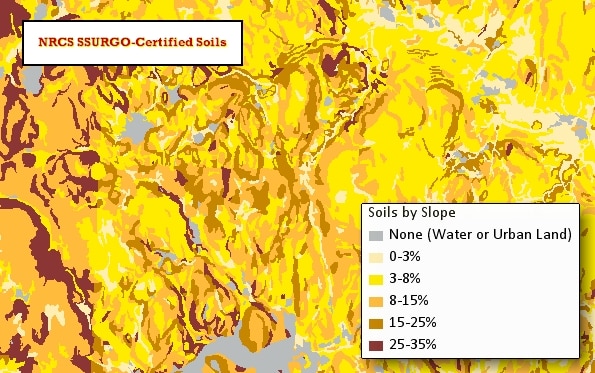
| SLOPE | Slope Code | Slope of the landscape, derived from the last character of the MUSYM field, if present. MassGIS added this field. Codes include: A: 0-3% These codes do not strictly correspond to the values in the SLOPE_1 field. |
| AREANAME | Area Name | Soil Survey Area name |
| MUNAME | Map Unit Name | Soil map unit name |
| COMPNAME | Component Name | Name of the dominant component of the soil map unit |
| MUKIND | Map Unit Kind | The kind of mapunit |
| FRMLNDCLS | Farmland Classification | Identification of map units as prime farmland, farmland of statewide importance, or farmland of unique importance. |
| HYDRCRATNG | Hydric Rating by Map Unit | Hydric soils are defined by the National Technical Committee for Hydric Soils (NTCHS) as soils that formed under conditions of saturation, flooding, or ponding long enough during the growing season to develop anaerobic conditions in the upper part (Federal Register, 1994). Under natural conditions, these soils are either saturated or inundated long enough during the growing season to support the growth and reproduction of hydrophytic vegetation. Reported for the dominant component of the map unit. |
| DRAINCLASS | Drainage Class | The natural drainage condition of the soil refers to the frequency and duration of wet periods. This column displays the dominant drainage class for the map unit, based on composition percentage of each map unit component. |
| MINSURFTEXT | Mineral Surface texture | The soil texture description of the first mineral soil horizon. Reported for the dominant component of the map unit. |
| TFACTOR | T Factor | Soil loss tolerance factor. The maximum amount of erosion at which the quality of a soil as a medium for plant growth can be maintained. Reported for the dominant component of the map unit. |
| AWS100 | Available Water Storage 0-100 cm | Available water storage (AWS). The volume of water that the soil, to a depth of 100 centimeters, can store that is available to plants. It is reported as the weighted average of all components in the map unit and is expressed as centimeters of water. AWS is calculated from AWC (available water capacity) which is commonly estimated as the difference between the water contents at 1/10 or 1/3 bar (field capacity) and 15 bars (permanent wilting point) tension and adjusted for salinity and fragments. |
| AWS25 | Available Water Storage 0-25 cm | Available water storage (AWS). The volume of water that the soil, to a depth of 25 centimeters, can store that is available to plants. It is reported as the weighted average of all components in the map unit and is expressed as centimeters of water. AWS is calculated from AWC (available water capacity) which is commonly estimated as the difference between the water contents at 1/10 or 1/3 bar (field capacity) and 15 bars (permanent wilting point) tension and adjusted for salinity and fragments. |
| DEP2WATTBL | Depth to Water Table | The shallowest depth to a wet soil layer (water table) at any time during the year expressed as centimeters from the soil surface, for components whose composition in the map unit is equal to or exceeds 15%. *These values are derived from the national database. They are intended for general planning purposes only and are not, in any way, intended to replace or supersede an on-site investigation. On-site investigations by certified soil evaluators are required by MA Environmental Code Title V for siting septic systems. |
| DWELLWB | Dwellings with Basements | The rating of the map unit as a site for dwellings with basements, expressed as the dominant rating class for the map unit, based on composition percentage of each map unit component. |
| HYDROLGRP | Hydrologic Soil Group | Hydrologic Group is a grouping of soils that have similar runoff potential under similar storm and cover conditions. This column displays the dominant hydrologic group for the map unit, based on composition percentage of each map unit component. |
| NIRRLCC | Nonirrigated Land Capability Class | This column displays the dominant capability class and subclass, under non-irrigated conditions, for the map unit based on composition percentage of all components in the map unit. |
| ROADS | Local Roads and Streets | The rating of the map unit as a site for local roads and streets, expressed as the dominant rating class for the map unit, based on composition percentage of each map unit component. |
| SEPTANKAF | Septic Tank Absorption Fields | The rating of the map unit as a site for septic tank absorption fields, expressed as the dominant rating class for the map unit, based on composition percentage of each map unit component. *These values are derived from the national database. They are intended for general planning purposes only and are not, in any way, intended to replace or supersede an on-site investigation. On-site investigations by certified soil evaluators are required by MA Environmental Code Title V for siting septic systems. |
| SLOPE_1 | Representative Slope | The difference in elevation between two points, expressed as a percentage of the distance between those points. This column displays the slope gradient of the dominant component of the map unit based on composition percentage. This field is named SLOPE in the data maintained by the NRCS. |
| FLOODING | Flooding Frequency Class | The annual probability of a flood event expressed as a class. This column displays the dominant flood frequency class for the map unit, based on composition percentage of map unit components whose composition in the map unit is equal to or exceeds 15%. |
| PONDING | Ponding Frequency Class | The annual probability of a ponding event expressed as a class. This column displays the dominant ponding frequency class for the map unit, based on composition percentage of map unit components whose composition in the map unit is equal to or exceeds 15%. |
| CORCONCRET | Corrosion of Concrete | "Risk of corrosion" pertains to potential soil-induced electrochemical or chemical action that corrodes or weakens concrete. The rate of corrosion of concrete is based mainly on the sulfate and sodium content, texture, moisture content, and acidity of the soil. Special site examination and design may be needed if the combination of factors results in a severe hazard of corrosion. The concrete in installations that intersect soil boundaries or soil layers is more susceptible to corrosion than the concrete in installations that are entirely within one kind of soil or within one soil layer. The risk of corrosion is expressed as "low," "moderate," or "high." Reported for the dominant component of the map unit. |
| TAXCLNAME | Soil Taxonomy Classification | A concatenation of the Soil Taxonomy subgroup and family for a soil (long name). Reported for the dominant component of the map unit. |
| CM2RESLYR | Depth to Any Soil Restrictive Layer | The distance in centimeters from the soil surface to the upper boundary of any restrictive layer. Reported for the dominant component of the map unit. |
| RESKIND | Restriction Kind | Type of nearly continuous layer that has one or more physical, chemical, or thermal properties that significantly reduce the movement of water and air through the soil or that otherwise provides an unfavorable root environment. Reported for the dominant component of the map unit. |
| PARMATNM | Parent Material Name | Reports the name for each of the parent materials that may occur in a vertical cross section of a soil. Reported for the dominant component of the map unit. |
| UNIFSOILCL | Unified Soil Classification (Surface) | Reports the Unified soil classification group symbol for the first mineral horizon of the dominant component of the map unit. |
| AASHTO | AASHTO Group Classification (Surface) | Reports the American Association of State Highway and Transportation Officials (AASHTO) class rating for the first mineral horizon of the dominant component of the map unit. |
| KFACTRF | K Factor, Rock Free | An erodibility factor which quantifies the susceptibility of soil particles to detachment by water. Reported for the first mineral horizon of the dominant component of the map unit. |
| KFACTWS | K Factor, Whole Soil | An erodibility factor which quantifies the susceptibility of soil particles to detachment and movement by water. This factor is adjusted for the effect of rock fragments. Reported for the first mineral horizon of the dominant component of the map unit. |
| PHWATER | pH (1 to 1Water) | The average relative acidity or alkalinity of a soil the first mineral horizon of the dominant component of the map unit. *Note that the soil pH can be highly influenced by soil management. |
| CLAY | Percent Clay | The percent clay in the first mineral horizon of the dominant component of the map unit. Calculated as mineral particles less than 0.002mm in diameter as a weight percentage of the less than 2.0mm fraction. |
| KSAT | Saturated Hydraulic Conductivity (Ksat) | The amount of water that would move vertically through a unit area of saturated soil in unit time under unit hydraulic gradient (in/hr). Reported for the first mineral horizon of the dominant component of the map unit. |
| OM | Organic Matter | The amount by weight of decomposed plant and animal residue expressed as a weight percentage of the less than 2 mm soil material. Reported for the first mineral horizon of the dominant component of the map unit. |
| SAND | Percent Sand | The percent sand in the first mineral horizon of the dominant component of the map unit. Calculated as mineral particles 0.05mm to 2.0mm in equivalent diameter as a weight percentage of the less than 2 mm fraction. |
| NLEACHING | Nitrate-Nitrogen Leaching Potential (MA) | An indicator of the potential for nitrates dissolved in water to percolate to the groundwater. In Massachusetts, the rating is based on a soil interpretation that uses soil and climate properties in the National Soil Information System (NASIS) database and results in a ranking of low, moderate, or high potential for nitrate-nitrogen leaching. Reported for the dominant component of the map unit. |
Special Features
Each special/ad hoc feature (SOILS_SPECFEAT_ARC and SOILS_SPECFEAT_PT) contains the following fields:
| Field Name | Description |
|---|---|
| AREASYMBOL | The identifying symbol given to the specified geographic area to which the legend applies. |
| SPATIALVER | A sequential integer number used to denote the serial version of the spatial data for a soil survey area. |
| FEATSYM | A symbol that, within the context of a particular soil survey area, uniquely identifies a point or line spot feature. Current codes include: BLD - Boulder spot |
| FEATKEY | A non-connotative string of characters used to uniquely identify a record in the Feature Description table. |
| SS_AREA | Abbreviation of the survey area (field added by MassGIS) |
| LABEL | Equal to the FEATSYM field, kept in the data distributed by MassGIS for legacy application purposes. |

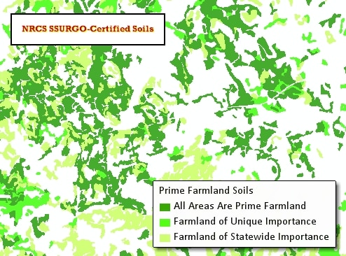
Prime Farmland Soils
MassGIS has created the spatial view SOILS_POLY_PRIMEFARMLAND, based on the FRMLNDCLS field in the SOILS_MUPOLYGON_TOP20 feature class.
The layer comprises three important farmland categories. Urban built-up land and water are excluded from all three categories, but forested lands are included in all three categories if they meet the appropriate criteria.
The data for each of the 19 soil surveys was acquired and compiled over various time periods. Since then, development of important farmland soils has occurred in some areas and that land is no longer available for agriculture.
Categories of prime farmland include:
| Category | Description |
|---|---|
| Prime Farmland | Land that has the best combination of physical and chemical characteristics for economically producing sustained high yields of food, feed, forage, fiber, and oilseed crops, when treated and managed according to acceptable farming methods. |
| Farmland of Statewide | This is land, in addition to prime and unique farmlands, that is of statewide importance for the production of food, feed, fiber, forage, and oil seed crops, as determined by the appropriate state agency or agencies. Generally, these include lands that are nearly prime farmland and that economically produce high yields of crops when treated and managed according to acceptable farming methods. |
| Farmland of Unique Importance | Land other than prime farmland or farmland of statewide importance that might be used for the production of specific high value food and fiber crops. Examples of such crops are tree nuts, cranberries, fruit, and vegetables. In Massachusetts, Unique soils are confined to mucks, peats, and coarse sands. Cranberries are the primary commercial crop grown on these soils. The presence of other crops on these soils is usually, possibly always, limited to small, incidental areas. |
Additional Resources
Massachusetts Criteria for Assigning Important Farmland Designations to Soil Survey Map Units
The following describes standards for assigning Important Farmland Classes to soil survey map units of Massachusetts soil survey areas.
Criteria for the designation “Prime Farmland” per Code of Federal Regulations (CFR)
The prime farmland class is assigned to soil map units, the major component/s relative value data[1] for which, meet prime farmland criteria per 7CFR657.5 as edited to exclude soil properties and climate not relevant to Massachusetts, and to quantify adequate available water holding capacity as follows:
- available water capacity of 3.5 in (8.9 cm) or more[2] within a depth of 40 in (1 m) or the depth to an impermeable layer if less than 40 in (1 m) and,
- pH between 4.5 and 8.4 in all horizons within a depth of 40 in (1 m) and,
- water table, if present, not shallower than 15 in (38 cm) during May through October and,
- infrequent (less often than once in 2 years) or no flooding during May through October and,
- the product of Kw (erodibility factor, whole soil) of the mineral soil surface and percent slope is less than 2.0[3]; and,
- permeability rate of at least 0.06 in (0.15 cm) per hour in the upper 20 in (50 cm); and,
- upper 6 in (15 cm) of the soil surface contains less than 10 percent rock fragments by volume coarser than 3 in (7.6 cm) diameter; and,
- not more than 0.1 percent of the soil surface is covered by stones 10 in (25cm) to 24 in (60cm) diameter, and/or boulders >24 in (60 cm) diameter, and.
- less than 2 percent bedrock exposure.
Qualifiers for data application to Massachusetts soil survey map unit prime farmland criteria per CFR:
- Entire pH data range is applied to the pH criterion. All soil survey map unit components that otherwise meet prime farmland criteria have mineral horizon pH ranges w/in the CFR criterion.Tillage and accepted agricultural practices negate the pH limitation where attribute relative value is less than 4.5.
- Map units having a predominance of soils of coarse-loamy or coarse-silty particle size class overlying densic contact on 0 to 8% slopes with available water capacity data values <3.5 in (8.1 cm), and that meet remaining criteria per CFR are designated prime farmland. Although attribute data indicates the available water holding capacity minimum of 3.5 in (8.1 cm) is not met, these soils maintain a reservoir of moisture that supports plant growth due to reduced gravitational water loss and meets criteria per CFR of adequate moisture supply for the crops commonly grown. This qualifier is applicable to soil map components with moderately coarse to medium textured mantles overlying lodgment till.
- Where the product of K and slope percent is 2 or less for the lower part of a 3 to 8 percent map unit slope phase range but exceeds 2 for the upper part of the slope range, and remaining criteria per CFR are met, the map unit is designated prime farmland.
- Map units that meet all prime farmland criteria per CFR except the relative value data representing the predominant components reflects available water capacity of less than 3.5 in (8.9 cm) through the upper 40 in (1 m) but has sufficient available water capacity in the upper profile, are designated prime farmland. This qualifier is applicable to soil survey map unit components having moderately coarse to medium textured mantles overlying coarse textured deposits.
- Complexes and Associations - Soil map units with more than 50 percent components that meet any of the above scenarios are designated prime.
Criteria for the designation “Farmland of Statewide Importance”
- Soil map units, the predominant composition of which does not meet criteria for prime farmland and have all the following characteristics…
- available water capacity of 2.0 in (5.1 cm) or more[4] within a depth of 40 in (1 m); and,
- pH between 4.5 and 8.4 in all horizons within a depth of 40 in (1 m) and,
- water table, if present, not shallower than 15 in (38 cm) during May through October; and,
- infrequent (less often than once in 2 years) or no flooding during May through October; and,
- the product of Kw (erodibility factor, whole soil) of the mineral soil surface and percent slope is less than 4.2[5]; and,
- permeability rate of at least 0.06 in (0.15 cm) per hour in the upper 20 in (50 cm); and,
- upper 6 in (15 cm) with less than 35 percent rock fragments by volume coarser than 3 in (7.6 cm); and,
- not more than 3 percent of the soil surface is covered by stones 10 in (25 cm) to 24 in (60 cm) diameter and,
- not more than 0.1 percent of the surface is covered by boulders >24 in (60 cm) diameter, and
- less than 2 percent bedrock exposures.
Qualifiers for data application to Massachusetts Farmland of Statewide Importance Criteria
- Where the product of K and slope percent is 4.2 or less for the lower part of an 8 to 15 percent map unit slope phase range but exceeds 4.2 for the upper part of the slope range, and remaining criteria are met, the map unit is designated farmland of statewide importance.
- Complexes and Associations - Soil map units with more than 50 percent components that meet the above criteria are designated farmland of statewide importance.
Important Farmland Soil Map Unit Designation Overriding Scenarios
Application of anomalous or non-representative data elements to important farmland criteria may result in inaccurate class placement. The consideration of the characteristics of the soil survey map unit as a whole as assessed by Massachusetts NRCS staff overrides point specific data.
K factors and available water capacity data for the same nominal component may vary among soil survey areas resulting in different data-derived farmland classes. The characteristics of the predominant condition based on acreage extent will be applied state-wide for prime farmland and farmland of state-wide importance designations.
The following address specific scenarios where calculations based on attribute data may inaccurately place a map unit in prime farmland or farmland of statewide Importance classes. Soil map units having any of the following characteristics are precluded from important farmland designations:
- A major component that is shallow to lithic contact: complex slopes, surface stones and boulders associated with these map units, and very shallow components within these landscapes are significant limitations to agriculture.
- Slope phase range that includes 20 percent or more. Per recommendation from MA NRCS ecological sciences staff, 20 percent slope or greater is limiting for equipment operations.
- Hydric soil composition greater than or equal to 50 percent.
- Quartzipsamment composition greater than or equal to 50 percent: droughty, inherently low fertility.
- A major component of urban land and/or major component classified to level above series i.e. Udorthents.
- Map unit complexes associated with the undulating, rolling, irregular slopes of the Cape Cod terminal moraines.
Soil map units having any of the following characteristics are precluded from the designation, Prime Farmland:
- Composition of soil components in the sandy-skeletal particle size class greater than or equal to 50 percent.
- Slope phase range that exceeds 8 percent.[6]
Unique Farmland
Soil survey map units designated as Unique Farmland, are those suitable for, and have an established history of cranberry production. The Unique Farmland designation is excluded from soil survey areas with few or no lands with cranberry production.
[Footnote 1] Relative value refers to the value assigned to specific data elements in the National Soils Information System. Application of anomalous or non-representative values to important farmland criteria may result in inaccurate class placement. The consideration of the characteristics of the soil map unit as a whole overrides point specific data as determined by Massachusetts NRCS staff.[1] Based on data, some map units meet Prime Farmland criteria on the lower part of the 8-15 percent slope range. About a dozen map units with available water capacity >3.5 inches and Kw of .1, .2, .15, or .17 were noted, all of which have loamy surface textures and parent material like other map units with higher Kw factors. The decision to exclude slopes greater than 8 percent from Prime Farmland is based on the preponderance of attribute data for similar soils.
[Footnote 2] Available water capacity needs determined from “Conservation Irrigation Guide for Massachusetts, 1981”
[Footnote 3] Slope range values applied to this criterion exclude the lowest whole number in the range to separate overlap with the adjacent lower slope phase as follows: 0-3, 4-8, 9-15.[1] Available water capacity needs determined from Conservation Irrigation Guide for Massachusetts, 1981
[Footnote 4] Product of K and slope criterion based on historical precedent, MA Soil Conservation Service document, “Additional Farmland of State or Local Importance”,1/17/1986. Slope range values applied to this criterion exclude the lowest whole number in the range to separate overlap with the adjacent lower slope phase as follows: 0-3, 4-8, 9-15.
[Footnote 5] Based on data, some map units meet Prime Farmland criteria on the lower part of the 8-15 percent slope range. About a dozen map units with available water capacity >3.5 inches and Kw of .1, .2, .15, or .17 were noted, all of which have loamy surface textures and parent material like other map units with higher Kw factors. The decision to exclude slopes greater than 8 percent from Prime Farmland is based on the preponderance of attribute data for similar soils.
Displaying the Data
Layer files from MassGIS
The data downloads from MassGIS contain several ArcMap (.lyr) layer files, based on some attributes in the “Top 20” feature class. These map layers also may be found in the 'Physical Resources' section of MassMapper.
Soil Data Viewer extension

The non-top 20 soils polygons have very few attributes. Users should have a solid understanding of the data to properly map and analyze them.
To decipher the many ways in which the soils data may be interpreted and displayed, using the related tables, the USDA/NRCS has developed the Soil Data Viewer, a free extension for ArcMap 8.3, 9.x, and 10.x. Visit the Soil Data Viewer page and click on "Download and Install Soil Data Viewer." Important note: This extension works only with the soils data downloaded from the Web Soil Survey for one survey area at a time.
Web Soil Survey

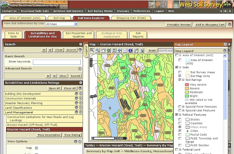
Use the NRCS’ Web Soil Survey, an online soils viewer that displays several user-specified characteristics of soils. Users also may download data by survey area or a user-specified area of interest.
Maintenance
These datalayers are maintained by the NRCS. The Massachusetts Department of Agricultural Resources will provide updates to MassGIS yearly based on updated data it receives from the NRCS.
Additional References
Further information is available in the form of documents produced and maintained by the NRCS. These documents include:
- USDA NRCS Massachusetts Soils – This website is managed by Massachusetts NRCS and contains information on ongoing soil survey projects, local soil interpretations, and other soil survey resources.
- SSURGO Metadata - Documents, diagrams and reports describing the SSURGO standard, as well as the tools and procedures that are necessary to effectively use the data.
- National Soil Survey Handbook - This multi-chapter guide provides the main operational and procedural guidance for conducting the NRCS portion of the National Cooperative Soil Survey program.
- Soil Survey Manual - This single volume book provides the major principles and practices needed for making and using soil surveys and for assembling and using data related to them. The Manual is intended primarily for use by soil scientists engaged in the classification and mapping of soils and in the interpretation of soil surveys. Although the Manual is oriented to the needs of those actively engaged in preparing soil surveys for publication, workers and students who have limited soils experience or are less familiar with the soil survey process also will be able to use the information.
- National Soil Information System (NASIS) - NASIS consists of multiple interrelated soil applications and databases. This data system aids in the collection, storage, manipulation, and dissemination of soil information.