- Division of Fisheries and Wildlife
- MassWildlife's Natural Heritage & Endangered Species Program
Media Contact
Media Contact, MassWildlife
Buzzard's Bay watershed has one of the most diverse landscapes in Massachusetts. This summer, MassWildlife carried out a range of conservation projects, including terrapin counting in, botanical and habitat work, prescribed burns, herring passage monitoring, and stream surveys throughout the region. These efforts highlight the agency’s commitment to protecting wildlife, restoring habitats, and supporting biodiversity across southeastern Massachusetts. Read on to learn more about each project and see photos of the work in action.
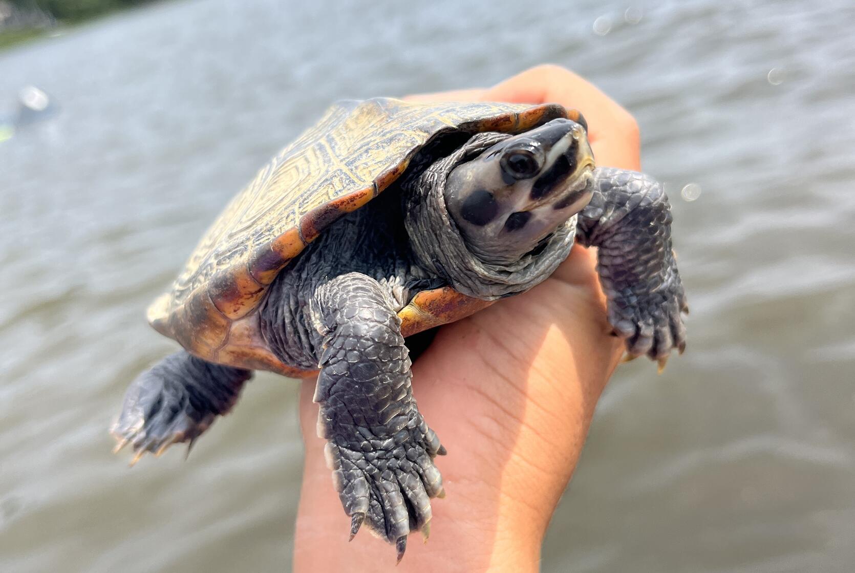
Terrapin counting in Wareham
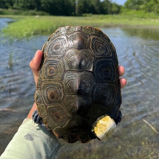
What are those people doing on their kayaks with big nets in the Wareham and Agawam Rivers? That’s MassWildlife surveying diamond-backed terrapins! Diamond-backed terrapins are an estuarine turtle with a range spanning from Wellfleet, MA to the Texas Gulf Coast. They face threats from habitat loss, habitat degradation, road mortality, poaching, and drowning from being caught in crab traps. Due to their threatened status, it’s important to get population estimates and identify critical habitat sites for conservation management. With the help of Zoo New England and the University of South Florida, MassWildlife’s field team conducted visual surveys at multiple sites through the Buzzard’s Bay estuary, from Onset to Dartmouth. This year, MassWildlife trapped, marked, and released about 800 turtles to estimate population size. To learn about turtle movements throughout the year, field staff attached acoustic transmitters to 25 females, bringing the total of tagged terrapins to 55.
150 years of botanical surveys on Penikese Island

Found towards the tip of the Elizabeth Island chain, MassWildlife manages a wildlife sanctuary on Penikese Island. This summer, the island celebrated 150 years of botanical surveys. MassWildlife's botanists Robert Wernerehl and Karro Frost, alongside 18 volunteers, conducted the most recent botanical surveys on the island. Plants, like the slender sea purslane, were recorded over the course of two days. This kind of work is important to biologists because the surveys allow them to set a baseline to monitor flora change over time. Read a more in-depth interview about the importance of the survey work done on Penikese Island.
Habitat team on Penikese Island
Botanical surveying wasn’t the only activity on Penikese Island this summer! MassWildlife’s seasonal habitat management crew treated 22 acres for invasive plants—including black swallow-wart, Japanese honeysuckle, and Oriental bittersweet—with herbicides. Targeted herbicide treatments control invasive plant species that threaten the health and biodiversity of the 75-acre island. The native plants that make up the maritime grasslands and shrublands on the island serve as nesting habitat for the roseate tern (Sterna dougallii) and common tern (Sterna hirundo), which are both listed under the Massachusetts Endangered Species Act (MESA). MassWildlife uses a variety of tools to restore and maintain healthy habitats including herbicide application, cutting or mowing, prescribed fire, and reseeding with native plants.

Prescribed Fire at Frances A. Crane WMA
Frances A. Crane Wildlife Management Area (WMA) is an ecological gem, containing some of the region’s most diverse and important habitats including nearly 2,500 acres of sandplain grasslands, pitch pine barrens, and pitch pine–oak forests and woodlands. It is home to over 20 MESA-listed species. The habitats on the WMA are dependent on fire to grow and thrive, making Frances A. Crane one of MassWildlife’s most active prescribed fire sites. In 2025, MassWildlife, with the assistance of its many partners including DCR, AmeriCorps, the Massachusetts Army National Guard, the Mashpee Wampanoag Tribe, Buzzards Bay Coalition, and local fire departments, conducted prescribed fires on 234 acres over the course of four burn days. Every prescribed fire followed a detailed plan to safely achieve restoration objectives, such as improving habitat for specific wildlife species or promoting seedling recruitment for certain plants.

Red Brook herring passage
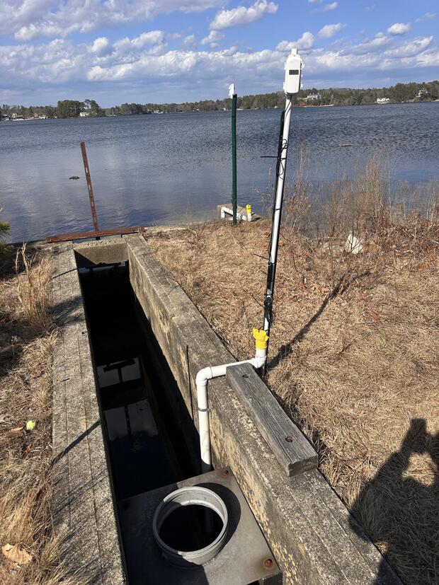
Massachusetts is home to anadromous fish that rely on saltwater most of their adult lives but migrate to freshwater to spawn. Herring passages are a way for these fish to navigate to their spawning locations that were previously closed off by human development. MassWildlife manages the Red Brook WMA herring passage that runs through a former cranberry bog to their spawning location. This connection of Red Brook to White Island Pond is in fact not natural and is an example of how species have adapted to human influence from over 100 years ago. A channel between the original headwaters of Red Brook and White Island Pond was hand dug in the 1800s to provide herring access to the pond for breeding. Because of this, MassWildlife Southeast District staff monitor the brook and adjust the flow of water in the fishway as needed to allow for fish passage. This year, through ResilientMass funding, they installed water level and temperature monitoring equipment to keep tabs on flows in real time and react more quickly to issues that could impact blueback herring and alewife (collectively referred to as “river herring”) and the American eel, which are all listed as Species of Greatest Conservation Need in the Massachusetts State Wildlife Action Plan.
Stream surveys
Each summer, MassWildlife conducts surveys of a subset of streams on a rotating schedule to provide a baseline of fish populations data. MassWildlife’s fisheries biologists and technicians use a variety of techniques including backpack electroshocking to collect data on fish populations in streams. This equipment sends a low-level electric current through the water that temporarily stuns fish allowing them to be safely netted. The team records length and weights for each fish before releasing them. Stream surveys often involve partners from state, federal, local, non-profit, and tribal entities, especially if the data impacts nearby habitat restoration projects. Collectively, these data allow biologists to monitor changes in fish populations over time and understand how landscape changes alter fish communities. This year, 7 streams were surveyed in the Buzzard’s Bay Watershed.
This is only a fraction of the work being done in Buzzard’s Bay. Eelgrass research, coastal bird surveying, bald eagle banding, trout stocking, among other activities occurred all summer long. Next time you see the MassWildlife logo in your area, get curious and learn about how we are improving Massachusetts’s biodiversity.