Downloads
.zip file includes 22 shapefiles, the DAT .dbf table
and five ArcGIS 10.0 LYR files
Overview

The Solid Waste Diversion and Disposal Datalayer was initially compiled by the Department of Environmental Protection (MassDEP) to track the locations of transfer, incineration and/or land disposal of solid waste in Massachusetts. This statewide datalayer contains the majority of locations currently regulated under MassDEP's solid waste regulations (310 CMR 16.000 & 19.000).
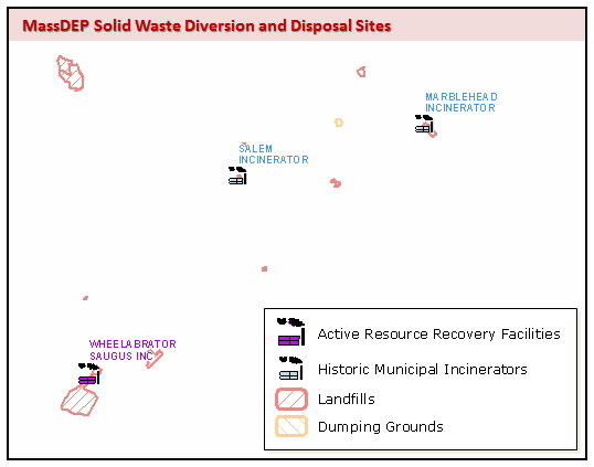
Land Disposal refers to an operation established in accordance with a valid site assignment for the disposal of solid waste into or on land (Landfill), or a location for disposal of solid waste from one or more sources which is not established or maintained pursuant to a valid site assignment or permit (Dumping Ground).
Polygons (SW_LD_POLY) and points (SW_LD_PT, one point for each polygon) include both Landfills and Dumping Grounds.
Please note, only a small fraction of the land disposal sites are active landfills. In addition, this datalayer does not contain all land disposal sites known to MassDEP. The MassDEP Waste Site Cleanup program and EPA Superfund Program manage former land disposal sites which fall under their regulatory purview. Waste site and mining classifications in the MassGIS Land Use datalayer and Map Unit Symbols 652 and 652E in the SSURGO Certified Soils datalayer may represent land disposal sites not found in the Solid Waste Diversion and Disposal Datalayer.
Solid Waste Diversion, including Transfer/Handling, Materials Recovery Facilities and Composting activities have been represented as point features since 2011. Regulatory changes initiated in 2012 have expanded capacity for organic waste diversion. Beginning in 2016 locations for these operations, exempt from site assignment and permits pursuant to 310 CMR 19.000, became available. To better understand diversion-related regulatory changes, helpful definitions can be found in Section 16.02 of the Solid Waste Site Assignment Regulations. General Permit operations are further described in 310 CMR 16.04; Individual Permit operations in 310 CMR 16.05. The Anaerobic Digestion & Organics Diversion page on mass.gov/dep may also be of interest.
Please note - the Commonwealth’s 2030 Solid Waste Master Plan establishes goals to reduce disposal statewide by 30 percent over the next decade, with a long-term goal of achieving a 90 percent reduction in disposal by 2050.
Manuscript
The MassDEP Diversion and Disposal of Solid Waste datalayer was originally digitized from USGS Quadrangle maps (1:25,000) filed as part of the siting (310 CMR 16.00) or operating permit (310 CMR 19.00) requirements for landfills. It has been updated as described below.
Methodology

1994 and earlier: DEP regional office files were searched for locus maps and site plans which designated the location of solid waste facilities. In some cases the facility footprint was located on the map; in other instances a generalized location (point or polygon) was noted. These were hand-drawn onto a master set of USGS topographic quadrangle maps from which the datalayer was digitized. In the absence of a landfill footprint, point locations were buffered to reflect permitted or reported acreage (when insufficient data was available, 29.9 acres was used). When possible, these buffered point locations were updated with polygons from MassGIS 1985 Land Use data.
1997-2008: Locus maps and site plans from regional and Boston office files were automated directly into Arc/Info while using scanned USGS quads &/or digital orthophotos as background images. Point locations were buffered as described above; several of these point locations were collected using global positioning system technology (GPS). Several polygons were copied from the Protected and Recreational Open Space and Land Use (2005) Datalayers.
2009 and beyond: GPS, parcel data, Pictometry (oblique view or "bird's eye" imagery), current/historical topographic maps and ortho imagery are being used to locate unmapped features and refine existing ones.
2024: LIDAR DEM and Shaded Relief have proven helpful in clarifying landfill footprints added/revised in this update. A holistic review of this datalayer would benefit from further use of this technology but is not planned at this time. Please direct specific polygon inquiries to Air.Quality@mass.gov.
Attributes
Land Disposal (polygon and point) feature attributes include:
| FIELD | TYPE / WIDTH | DEFINITION |
|---|---|---|
| RO_ACCT | Number / 10 | Site ID from Facility Master File (FMF) Database |
| SITE_NAME | Text / 45 | Site Name from FMF Database |
| ADDRESS | Text / 38 | Site Address from FMF Database |
| TOWN | Text / 21 | MassGIS Municipality name |
MassDEP maintains operational status, location, operation type, capacity and contacts in its Facility Master File (FMF) database, extracts of which can be found on MassDEP's website under the heading: “Disposal and Transfer Facilities”. Land Disposal attributes noted below are linked via the RO_ACCT field and included where appropriate, for ease of use. Data are current as of June 30, 2024.
Additional attributes via MassDEP database extract:
| FIELD | TYPE / WIDTH | DEFINITION |
|---|---|---|
| ACRES | Double | Acreage of polygon representing landfill/dumping ground |
| CAP_STATUS | Text / 10 | LF: Capped, Excavated, Incomplete; DG: Complete, Incomplete |
| CATGRPGIS | Text / 20 | Land Disposal – LF (landfill) or - DG (dumping ground) |
| LF_LINER | Text / 10 | LF: Lined, Not lined, unknown; DG: N/A |
| REGION | Text / 6 | MassDEP Region abbreviation |
| SW_ID | Text / 10 | Solid Waste Facility ID (historical identifier may be NULL for some records) |
| TYPE_OPER | Text / 10 | Contact Organization Type: District, Federal, Municipal, Private, State |
| TYPE_RSP | Text / 10 | Responsible Party Org Type: District, Federal, Individual, Municipal, Private, State |
| WASTE_TYPE | Text / 10 | Type of waste deposited: Ash, C&D Waste, MSW, Sludge, Tires, Woodwaste |
WASTE_TYPEs defined:
| Type | Description |
|---|---|
| ASH | Residual from combustion, includes MSW, oil, coal, & wood ash. |
| C&D WASTE | Construction & Demolition Waste. |
| MSW | Municipal Solid Waste |
| SLUDGE | Residual from treatment of gasses or fluids, includes industrial & water treatment sludges. |
| TIRES | Whole, cut, shredded, or chipped car or truck tires. |
| WOODWASTE | Trees, brush, sawdust, chips, bark and shavings, excluding milled lumber |
For ease of use, pre-selected sets of features based on the CATGRPGIS (Landfill or Dumping Ground): STATUS, CAP_STATUS and LF_LINER (for Landfills); and WASTE_TYPE (for Landfills and Dumping Grounds) were created using the polygon layer SW_LD_POLY and SW_LD_POLY_DAT table. The following views are distributed as separate shapefiles along with the full layers and tables in the download at the top of this page:
SW_LD_POLY_ACTIVE
SW_LD_POLY_ASH
SW_LD_POLY_CAPINCOMPLETE
SW_LD_POLY_CAPPED
SW_LD_POLY_CLOSED
SW_LD_POLY_DEMOLITION
SW_LD_POLY_DUMPINGGROUND
SW_LD_POLY_INACTIVE
SW_LD_POLY_LANDFILLS
SW_LD_POLY_LINED
SW_LD_POLY_LINERNONE
SW_LD_POLY_LINERUNKNOWN
SW_LD_POLY_MSW
SW_LD_POLY_SLUDGE
SW_LD_POLY_WOODWASTE
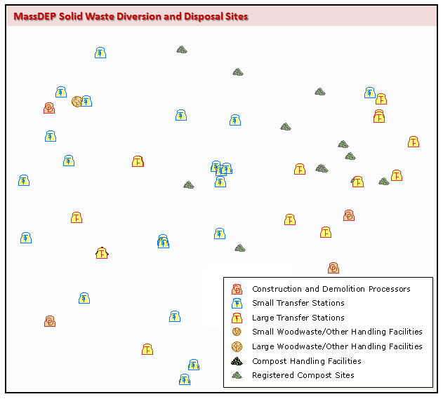
Solid Waste Operations other than Land Disposal (points) data structure mimics that of the BWP Major Facilities Datalayer. Attributes include FAC_ID and ROOT_ID which can be used to associate features with MassDEP Major Facilities and Underground Storage Tanks datalayers. Other than Land Disposal facility/operation views include:
BWP_PT_COMBUSTION (active combustion facilities with resource recovery)
BWP_PT_COMBUSTION_HISTORIC (inactive, historic incinerators)
BWP_PT_HF_CD_PROC (handling facilities: construction & demolition processors)
BWP_PT_HF_TRAN_SM (handling facilities: small transfer stations < 50 tons/day)
BWP_PT_HF_TRANSFER (handling facilities: large transfer stations, 50 tons or more/day)
BWP_PT_HF_WWCOOTH (handling facilities: woodwaste, compost, other)
BWP_PT_OPX_RECY_CONV (site assignment exempt recycling and waste conversion operations)
Handling Facility and site assignment exempt Operations additionally include a “classification type code” summarizing permit categories and types of solid waste activities permitted at these locations. CLASS_TYPE_CODEs as follows:
BWP_PT_HF_WWCOOTH (Handling Facilities requiring site assignment):
| Code | Description |
|---|---|
| CMPOST | Site Assigned Composting Facility |
| LGHNDL | Large Handling facility |
| SMHNDL | Small Handling facility |
BWP_PT_OPX_RECY_CONV (site assignment exempt Recycling, Composting or Conversion Operation): List is inclusive of all such CLASS_TYPE_CODEs, whether/not there are permitted operations for each code at any given time.
| Code | Description |
|---|---|
| GPCMPT | General Permit Composting |
| GPDGST | General Permit Aerobic/Anaerobic Digesting |
| GPRECY | General Permit Recycling |
| IPCMPT | Individual Permit - Composting RCC |
| IPCNVR | Individual Permit – Converting RCC |
| IPOTHR | Individual Permit - Other Handling RCC |
| IPRECY | Individual Permit – Recycling RCC |
| IPSMTR | Individual Permit - Small Transfer Organic Material |
Location Documentation
Land Disposal polygon location metadata are stored within the SW_LD_PT and SW_LD_POLY attribute tables. See DEP Standards for GIS Data for details. Polygon methods of data input are additionally coded as follows:
| DIG-METHOD | Description | Number of Polygons |
|---|---|---|
| F | Footprint digitized from USGS quadrangle or digital orthophoto | 522 |
| PAR | Polygon(s) copied from MassGIS Property Tax Parcels Datalayer | 55 |
| P | Point digitized from USGS quadrangle or digital orthophoto | 37 |
| UTM | Point located by UTM coordinates | 30 |
| SOI | NRCS SSURGO-Certified Soils polygon | 13 |
| LU | Polygon copied from MassGIS Land Use Datalayer | 6 |
| GPS | Perimeter or front gate points collected with GPS | 3 |
| GEO | Surficial Geology artificial fill polygon | 2 |
| OS | Polygon copied from MassGIS Protected and Recreational Open Space Datalayer | 1 |
Maintenance

If you have questions regarding this data, please contact the MassDEP Bureau of Air and Waste program.
Please note: although the MassDEP Bureau of Waste Prevention (BWP) has been reorganized as the Bureau of Air and Waste (BAW), the BWP prefix has been maintained in the naming convention of layers in our geodatabase.
In 2011: the datalayer was redesigned and feature level attribution increased. Land Disposal sites continued to be represented as polygons. Solid Waste Operations other than Land Disposal were represented as standalone points rather than associated features of land disposal polygons. This structure persists in subsequent updates.
In 2016: Point features representing Site Assignment/Operation Permit-exempt Recycling, Conversion and Composting activities were first included in the datalayer.
In 2024: Shifts noted between CLASS_TYPE_CODEs of both Solid Waste Diversion (points) and Land Disposal (polygon) activities. No operations are classified, and therefore none mapped as IPOTHR or IPSMTR. These are not considered errors. As in previous updates, all diversion-related operations have been mapped.
2011 modifications as follows:
- Active and historical COMBUSTION facilities, TRANSFER and registered COMPOST sites represented as points
- Active HANDLING/TRANSFER point views replace TRANSFER:
- BWP_PT_HF_CD_PROC (construction and demolition processors),
- BWP_PT_HF_TRAN_SM (small transfer stations),
- BWP_PT_HF_TRANSFER (large transfer stations),
- BWP_PT_HF_WWCOOTH (wood waste, compost and/or other waste handling operations)
- Polygon Views renamed: EPIC now DUMPINGGROUND; NOTLINED now LINERNONE; PARTIALLYCAPPED and NOTCAPPED rolled into new view CAPINCOMPLETE; STUMP now WOODWASTE
- Polygon Views deleted: LINERUNKNOWN, OTHER, RECYCLING, UNKNOWNCAP
2016 feature/attribute edits as follows:
- 3 new polygons
- 53 polygons redrawn
- 1 polygon ID edit
- 8 General Permit Composting Operations added (BWP_PT_COMPOST)
- 44 Recycling, Digestion and Waste Conversion sites mapped (new layer: BWP_PT_OPX_RECY_CONV)
2024 feature/attribute edits and data offering changes as follows:
- 10 new polygons
- 15 polygons revised
- 52 polygon attribute edits: 5 ID edits, 6 metadata edits and 42 address clarifications
- Significant growth noted in operation permit exempt Recycling, Compost and Conversion universe (previously 195 GPCMPT and 44 others, total now: 300 operations)
- Clarification of compost/organics universe: BWP_PT_COMPOST shapefile is no longer provided. Site assignment exempt Recycling, Composting and other waste Conversion Operations can be found in BWP_PT_OPX_RECY_CONV; Compost Handling Facilities in BWP_PT_HF_WWCOOTH.
- ArcGIS Services became available; MassMapper display options were aligned in tandem:
- Active Landfills and Combustion Facilities
- Land Disposal, symbolized by waste type and status
- Active, Inactive and Closed Landfills
- Dumping Grounds
- Combustion Facilities
- Active and Closed/Historic
- Handling Facilities
- C&D Processors
- Transfer - small and large
- Compost, Woodwaste and other
- Site assignment exempt Waste Diversion
- Composting and Waste Conversion Operations
- Recycling Operations
| Last updated: | January 23, 2025 |
|---|