March MaGICC Meeting - Data Stewardship
The Massachusetts Geospatial Information Coordinating Council (MaGICC) met on March 11, 2026. This was the Council’s fourth meeting. MaGICC is focused on policy issues to guide the Commonwealth’s geospatial ecosystem, often referred to as the Massachusetts Spatial Data Infrastructure (MSDI). At this meeting, the Council discussed a draft policy statement on MSDI data stewardship and initiated discussion on a geospatial data sharing policy.
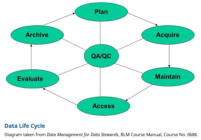
The policy statement on data stewardship will define a recommended policy to guide stewardship for the Commonwealth’s shared geospatial data assets. Data stewardship policy is an important aspect of a shared asset like the MSDI, which comprises many datasets that are managed collectively by many stakeholders across multiple sectors, including government, private sector, non-profit and higher education. Geospatial data are expensive to create and maintain, as well as to form into datasets of documented quality, accuracy, currency, and completeness. Well managed stewardship practices reduce data duplication and prevent periodic data re-collection and redevelopment by multiple organizations.
Stewardship means having a single organization take on the role of data steward for a shared data set, ensuring that data from various sources is regularly ingested to maintain the dataset on behalf of the enterprise, which includes all geospatial data users across the Commonwealth. That stewardship creates a certainty that enables others to expend resources on applications that rely on that data, rather than many organizations collecting the data only for their own purposes.
Stewardship for the entire data life cycle (diagram below) will ultimately be the responsibility of a single organization for a particular dataset or data theme (e.g., parcels, roads, addresses, trails, etc.). But there may be many organizations involved in the various aspects of the data life cycle, all coordinated by the data steward for that dataset or data theme. For example, MassGIS is the steward for the MSDI statewide parcel dataset, but many other organizations, particularly municipal assessors and the state Bureau of Local Assessment, play critical roles in planning, acquiring/creating, maintaining, etc., the data that makes up the statewide parcel dataset. The Council worked on a draft data stewardship policy statement at the March 2026 meeting. A few revisions were suggested and that policy statement will likely be finalized at its next meeting in June 2026.
Imagery and LIDAR Survey
MassGIS is assessing our Imagery and LIDAR programs for the Commonwealth to better meet our stakeholders' needs. This survey will help us better understand key aspects of our programs, including coverage areas, resolutions, and other imagery types required to complete projects. Your answers will help us improve our data assets. Here is the link: Imagery and LIDAR Survey
Please complete the survey by May 15th at 3 p.m. Eastern.
If you have any questions, please send an email about the imagery and LIDAR survey to massgismail@mass.gov.
Empowering Address Validation Through a New Experience Builder App
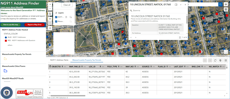
What if verifying your address in the 911 system were as easy as opening a web app?
That question helped drive the development of a new web-based application designed to connect people directly with the Commonwealth’s 911 address data. Built for use by municipal staff, residents, and even telecommunications providers, the app offers a simple way to check whether an address exists in the 911 database—and act if it doesn’t.
At its core, the application is about visibility. Users can search for an address and immediately see how it appears in the official dataset used by emergency services. These are the same data that support 911 operations statewide, presented in a format that is easy to explore and understand. For those who need it, the dataset is also available for download, making it useful for local analysis.
This is an evolving product, currently in active development. We are piloting the application in the Town of Natick to better understand how users interact with the tool, identify areas for improvement, and validate the overall approach. If the pilot is successful, we plan to expand gradually with the goal of eventually supporting a statewide rollout once we have sufficient confidence in both the functionality and the value of the application.
The app goes beyond lookup. It also creates a pathway for improvement. When users encounter missing or incorrect information, they can submit a report directly through the application. This feedback is intended to help identify gaps that might otherwise go unnoticed.
The project is grounded in a simple idea: people care about their addresses. Whether it’s ensuring emergency responders can find a specific apartment or confirming that a service provider has accurate location data, there is real value in giving users a way to validate and contribute to the dataset.
By opening up access and inviting participation, this application represents a shift toward more collaborative data stewardship. Instead of relying solely on internal updates, it brings in perspectives from the communities served by the data.
The result is a tool that not only supports day-to-day verification, but also helps strengthen the overall quality of address data across Massachusetts—one submission at a time.
If you're interested in participating in this project or learning more, please email Notify911Address@mass.gov.
Cohasset Center for Student Coastal Research's Community Resilience Projects
The Cohasset Center for Student Coastal Research (CSCR) is a regional leader in actively engaging students in authentic, community-based, hands-on, environmental research. Small teams of students address real problems in their region, problems that they see in their watershed. CSCR provides the research tools and training students need to conduct a rigorous study and surrounds them with a supportive professional science & civic network. As a result, students produce and share actionable scientific findings of great value to community stakeholders.
Eight high school students from the CSCR presented their community resilience projects to MassGIS in April. The CSCR program required students to meet outside of school thirty times and complete ten tutorials from The Top 20 Essential Skills for ArcGIS Online book. The projects focused on community resilience, covering a range of topics including open space and clean water. Students analyzed data from the MassGIS website using ArcGIS Online.
| Student | High School | Presentation (Click to view the StoryMaps) |
|---|---|---|
| Owen MacDougall | Commonwealth School | In a Changing Climate, Protecting Our Community of Hingham |
| Liv DeGrass | Notre Dame Academy | Coastal Flood Risk in Hingham |
| Declan Bergan | Thayer Academy | Open Space Expansion and Preservation Cohasset, MA |
| Wilson Nussbaum | Cohasset High School | Sewer Vs Septic in Cohasset |
| Calvin Gainey | Cohasset High School | Cohasset's Expensive New Police Station |
| Henry Herman | Norwell High School | The Role of Conservation Land in Protecting Public Water in Norwell, MA |
| Christopher Maloney | South Shore Charter Public School | Weymouth Massachusetts Housing Problem |
| Rishik Kundu | Chelmsford High School | Chelmsford Vehicular Accidents Examination |
After successfully presenting their research, each student received a Certificate of Proficiency signed by Jason Snyder, Secretary of the Massachusetts Executive Office of Technology Services and Security; Cy Smith, MassGIS Director and State Geographic Information Officer; and Jack Buckley, CSCR Executive Director. Read more about the MassGIS-CSCR Partnership.

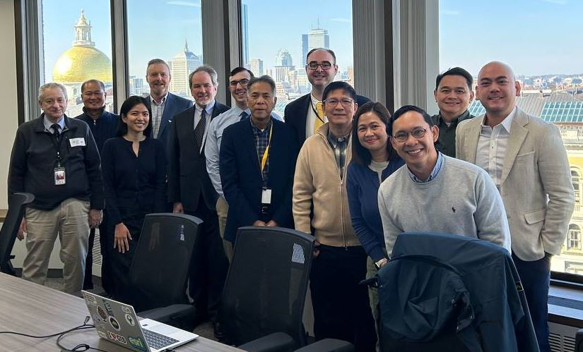
Philippines Supreme Court Delegation visits Massachusetts
On March 20, MassGIS Director Cy Smith and MassGIS staff members Craig Austin and Dan Valadas met with Stephen LaMonica, Chief Surveyor of the Massachusetts Land Court, and Jonathan Murry, Deputy Legal Counsel of the Massachusetts Land Court, along with a delegation of several staff members from the Philippines Supreme Court. The group discussed topics related to managing parcels in Massachusetts and court hearings concerning real estate. The meeting was arranged by the Land Court at the request of the Philippines Supreme Court staff as they traveled to Massachusetts to learn more about how land ownership registration is managed here. They are in the process of establishing a land ownership registration system in the Philippines.
The Massachusetts Land Court, located in the Suffolk County Courthouse in Boston, is a department of the Trial Court and has statewide jurisdiction over a wide range of cases involving real estate and land use. It also oversees the Commonwealth’s system for the registration of title to real property.
The meeting was held in the Fenway Conference Room in EOTSS' Boston office. After introductions, Cy, Craig, and Dan began with a brief presentation on how land parcel data are modeled and maintained in Massachusetts, followed by a Q&A session with the delegation. Land Court staff then connected virtually to enable the delegation to observe several land court hearings. Additional discussion followed.
MassGIS in the News
MassGIS on "Chronicle"
On February 5th, 2026, MassGIS appeared on a segment of WCVB Channel 5's popular "Chronicle" program. Cy Smith was interviewed about MassGIS while Aleda Freeman gave a demonstration of MassGIS' general purpose online mapping application MassMapper. Watch MassGIS on WCVB Channel 5 Chronicle (2 min 39 seconds).
20 Years of GeoServer
In the fall of 2025 MassGIS marked the 20th anniversary of using the open source mapping software GeoServer. To mark the occasion, GeoSolutions wrote up a two page Case Study highlighting the history of GeoServer at MassGIS and its use in MassMapper (previously OLIVER).
Data Updates
Property Tax Parcels
April 2026 - 25 municipalities: Barre, Berlin, Chicopee, Cummington, Easton, Erving, Groton, Heath, Holyoke, Lanesborough, Lenox, Lexington, Melrose, Milford, Millis, Rochester, Rowley, Sandisfield, Sharon, South Hadley, Tyngsborough, Washington, Williamstown, Winchendon, and Windsor.NOTE: As of the April 2026 update, MassGIS will begin replacing all .lyr files with .lyrx files in both the shapefile and file geodatabase downloads of municipal parcel data. ArcGIS Pro users will be able to use both, but ArcMap users will not be able to access the new .lyrx files.
- 2025 Aerial Imagery
April 2, 2026 - The latest statewide color aerial imagery from MassGIS. Appears as a basemap option in MassMapper and ArcGIS Online apps.
April 20, 2026 - Color-infrared (CIR) web tile layer added. - 2020 U.S. Census Towns
March 9, 2026 - Based on changes to the source data from the U.S. Census Bureau, MassGIS edited the new GEOID20 values, names in NAMELSAD20, and 5-digit values in COUSUBFP20 in the polygon layer. - Massachusetts Community Lookup Table
March 6, 2026 - Updated to add "BY-THE-SEA" to records for the Town of MANCHESTER. - Protected and Recreational Open Space
February 26, 2026 - Energy and Environmental Affairs GIS staff have updated the Protected and Recreational OpenSpace layers (arcs and polygons), available from MassGIS. Since the last publication to the web, staff at EEA and its associated agencies performed edits that improved the boundaries and/or descriptive geography to over 1,900 polygons in 194 municipalities.
Shapefile and file geodatabase downloads represent data updated as of 2/6/2026.
The details:- Added or improved the boundaries and attributes of many types of recreational areas and open spaces with various levels of protection: 129 conservation areas, 17 water supply lands (both state and local)/watershed restrictions, 38 agricultural preservation restrictions (all types)/community gardens, 36 parks/beaches/rail trails, 59 conservation restrictions/easements and 30 cemeteries.
- EEA additionally updated the database with numerous EEA-sponsored programs: 8 Conservation Land Tax Credits, 1 Parkland Acquisitions and Renovations for Communities (PARC) grant, 1 Conservation Partnership grant and 1 Drinking Water Supply Protection grant.
- Dams
February 25, 2026 - Extensive review and revised attribute table. First major update since 2012. - Licensed Child Care Programs
February 17, 2026 - Extensive update, including schema updates, of locations of licensed child care programs based on a list provided by the Department of Early Education and Care (EEC).
Events and Announcements
- Register - Spring 2026 NEARC Conference, May 26 at UMass Amherst, MA (Northeast Arc Users Group)
- Register - 2026 State of the Map Conference, June 11-13 in Madison, WI (OpenStreetMap)
- Save the Date - FOSS4G 2026 - November 2-4 in Sacramento, CA (Free and Open Source Software For Geospatial)
Contact
Online
Address
| Date published: | April 29, 2026 |
|---|