
Downloads
Overview
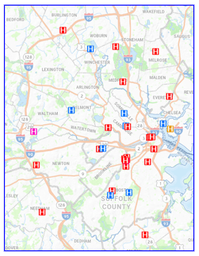
The hospitals are defined by four facility types:
- Acute care - licensed under MGL Chapter 111, section 51 and contain a majority of medical-surgical, pediatric, obstetric, and maternity beds, as defined by the Massachusetts Department of Public Health (DPH).
- Non acute care - psychiatric, rehabilitation, and chronic care facilities, along with some non-acute specialty hospitals. Non-acute care hospitals do not have 24/7 emergency departments.
- Satellite emergency facility - a fully equipped 24/7 emergency department located off the premises of a main hospital but listed on that hospital's license and legally authorized pursuant to 105 CMR 130.820 through 130.836 to accept patients transported by ambulance and provide the same level of adult and pediatric emergency care, advanced diagnostics, and laboratory services as a traditional hospital emergency department.
- Hospital inpatient unit - an off-site facility that operates under the license and administrative oversight of a main campus hospital to provide specialized 24-hour medical or psychiatric care.
The features in this layer are based on database information as of 3/31/2026 provided to MassGIS from the DPH, the Executive Office of Health and Human Services (EOHHS), the DPH Office of Emergency Medical Services (OEMS), and the Massachusetts Emergency Management Agency (MEMA).
The layer is named HOSPITALS_PT.
Production
The MassDEP GIS Group developed the original dataset by geocoding a table of hospitals provided by the Massachusetts Division of Healthcare Finance & Policy. For the December 2018 update, MassGIS compared the latest data from MDPH and CHIA with the previous (August 2009) version and added and removed features as needed. Points were snapped to features in the Master Address Data and the MAD ID was added. MassGIS also modified the attribute schema. CHIA reviewed the final revision in November 2018, and the data layer was updated based on data provided by CHIA and DPH.
With the August 2026 update, this data layer combines the now-deprecated Acute Care and Non-Acute Care Hospitals data layers and is intended to improve data update frequency. The layer includes satellite emergency facilities and hospital inpatient units that were previously excluded. This update also includes a major schema overhaul of the attribute table.
Attributes
The Hospitals point attribute table includes the following fields:
| Field Name | Description |
|---|---|
| DPH_FACILITY_ID | Mass. DPH ID value |
| FACILITY_NAME | Hospital name; may include hospital corporate system name and/or campus name |
| FMF_NAME | Hospital name as stored in the DPH facility master file |
| STREET_ADDRESS | Hospital address (street number and name) |
| MUNICIPALITY | Municipality the hospital is located in |
| ZIP_CODE | Hospital ZIP Code |
| COUNTY | County the hospital is located in |
| STATE | State the hospital is located in (all MA) |
| PHONE | Main telephone number of hospital |
| ICU | Number of Intensive Care Unit beds |
| CCU | Number of Critical Care Unit beds |
| MATERNAL | Number of Maternal Care beds |
| MED_SURG | Number of Medical Surgical beds |
| PEDIATRIC | Number of Pediatric beds |
| NICU | Number of Neonatal Intensive Care Unit beds |
| REHABILITATION | Number of Rehabilitation beds |
| PSYCH_LOCK | Number of Locked Psychiatric beds |
| PSYCH_UNLOCK | Number of Unlocked Psychiatric beds |
| BURN_UNIT | Number of Burn Unit beds |
| ICU_CCU_COMBO | Combined number of ICU and CCU beds |
| PEDIATRIC_ICU | Number of Pediatric ICU beds |
| ICU_CCU_BURN | Combined number of ICU, CCU, and Burn Unit beds |
| PSYCHIATRIC | Combined number of Psychiatric beds |
| TOTAL_BEDS | Total number of beds |
| DPH_STROKE_TIER | Stroke Center Tier as defined by DPH |
| TRAUMA_LEVEL_ADULT | Adult Trauma Center Level |
| TRAUMA_LEVEL_PEDS | Pediatric Trauma Center Level |
| EMERGENCY_DEPT | Emergency Department Status (Yes or No) |
| CHNA_REGION | CHNA Region |
| EOHHS_REGION | EOHHS Region |
| OEMS_REGION | OEMS Region |
| MEMA_REGION | MEMA Region |
| EMS_ZONE | EMS Zone |
| MAD_ID | ID for point location from MassGIS' Master Address Database |
Maintenance
MassGIS maintains this datalayer and will make updates quarterly as Mass. DPH sends updated data.
Also see the VA Healthcare layer.
| Date published: | August 20, 2026 |
|---|---|
| Last updated: | September 3, 2026 |