
Downloads
Overview
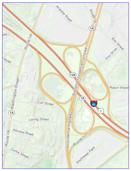
The MassGIS Roads dataset is a statewide line dataset representing roads throughout Massachusetts. Each feature represents a road segment and includes street-name information, left- and right-side address ranges, geographic attributes, and road classification.
The data originated with street centerlines developed and maintained by MassGIS for the Massachusetts 911 system and have evolved considerably over time. The current dataset is intended to provide an accurate representation of the street network as it exists on the ground, with primary street names generally corresponding to names posted on street signs or otherwise recognized as roadway names. Location and place names historically carried on the street centerlines are now more appropriately represented as address points, while alternate and other valid street names are maintained in the associated street name variants table. This approach provides a cleaner representation of the physical street network while preserving the additional naming and location information needed for address matching, public safety, and other GIS applications.
A significant feature of the Roads dataset is the inclusion of address ranges. These attributes support street-based geocoding and allow an approximate address location to be calculated through linear interpolation.
This layer is named MASSGIS_ROADS (in the MAD schema in MassGIS' enterprise geodatabases).
Production
The source street centerlines date to the early 2000s, when the Massachusetts State 911 Department asked MassGIS to assist with the geographic data needed to locate wireless 911 callers. MassGIS initially worked with commercial street centerline data supplied by Navteq, now HERE Technologies. These data included roadway geometry, street names, municipalities, and address ranges. MassGIS reviewed the data against the state's Master Street Address Guide (MSAG), investigated discrepancies, and submitted corrections for verification.
Beginning around 2011, MassGIS transitioned from submitting corrections to the commercial data provider to directly maintaining and enhancing the street centerlines used by the Massachusetts 911 system. The existing dataset continued to serve as the foundation, but MassGIS increasingly made its own edits to street geometry and attribution and added street segments and other features needed to support emergency response. Over time, these MassGIS-maintained centerlines evolved independently from the commercial product. One component, however—the address ranges associated with some street segments—continued to be derived from the original commercial data and remained subject to licensing restrictions that prevented unrestricted public distribution.
In 2026, MassGIS completed a project to replace the remaining commercially derived address ranges with ranges independently generated from public data. Candidate ranges were developed by analyzing the spatial relationships among the street centerlines, MassGIS address points, and standardized municipal parcel data. MassGIS developed and used an editing application to review the calculated ranges against the available geographic information. Automated processing was supplemented by extensive manual review because addressing practices vary throughout Massachusetts. Odd/even parity, mixed addressing, historical addressing practices, municipal conventions, and other irregularities can produce situations that require human interpretation. Approximately 150,000 road segments were reviewed and edited during the project. Completion of this work removed the legacy commercial-data restriction and enabled MassGIS to produce the Roads dataset as a publicly distributable data product.
Address Ranges
Address ranges are maintained separately for the left and right sides of each road segment. LEFT_FROM_ADDRESS and LEFT_TO_ADDRESS describe the range on the left side, while RIGHT_FROM_ADDRESS and RIGHT_TO_ADDRESS describe the range on the right side.
The ranges may be used for street-based geocoding and linear interpolation. Given an address number and matching street, an application can use the range to estimate the location of the address along the corresponding road segment.
Address ranges should not be interpreted as an inventory of existing addresses. For example, a range of 2–100 does not indicate that every even address between 2 and 100 exists.
Attributes
The line attribute table contains the following fields:
Identifiers and Record Information
| Field | Description |
|---|---|
| OBJECTID | Internal feature identifier. |
| BASESEG_ID | Unique identifier for the base road segment. |
| STNAME_ID | Identifier associated with the street name. |
| RCL_UNQ_ID | Unique identifier for the road centerline feature. |
| DATE_UPD | Date the feature or its attributes were last updated. |
| EFF_DATE | Date on which the record became effective. |
| EXP_DATE | Date on which the record expired, if applicable. |
| DATA_SRC | Source information associated with the road segment or its attribution. |
Street Name Attributes
Street names are provided as both standardized complete names and individual components to support applications such as address matching, geocoding, searching, and labeling.
| Field | Description |
|---|---|
| ST_NAME_STD | Complete standardized street name. |
| MSAG_STR | Street name used for Master Street Address Guide (MSAG) purposes. |
| PRE_MOD | Modifier preceding the primary street name. |
| PRE_DIR | Directional preceding the primary street name. |
| PRE_TYPE | Street type preceding the primary street name. |
| ST_NAME | Primary street-name component. |
| FS_PST_TYP | Standardized version of the street type, such as STREET, ROAD, AVENUE, or HIGHWAY. |
| POST_TYPE | Street type following the primary street name, such as ST, RD, AVE, or HWY. |
| POST_DIR | Directional following the primary street name. |
| POST_MOD | Modifier following the primary street name. |
Address Attributes
| Field | Description |
|---|---|
| L_FROM | Beginning address of the range on the left side of the road segment. |
| L_TO | Ending address of the range on the left side of the road segment. |
| PARITY_L | Left-side range parity: E (even), O (odd), or M (mixed). |
| R_FROM | Beginning address of the range on the right side of the road segment. |
| R_TO | Ending address of the range on the right side of the road segment. |
| PARITY_R | Right-side range parity: E (even), O (odd), or M (mixed). |
| L_FR_PREF | Prefix associated with the left-side from-address number. |
| L_FR_SUFF | Suffix associated with the left-side from-address number. |
| L_TO_PREF | Prefix associated with the left-side to-address number. |
| L_TO_SUFF | Suffix associated with the left-side to-address number. |
| R_FR_PREF | Prefix associated with the right-side from-address number. |
| R_FR_SUFF | Suffix associated with the right-side from-address number. |
| R_TO_PREF | Prefix associated with the right-side to-address number. |
| R_TO_SUFF | Suffix associated with the right-side to-address number. |
Geographic Attributes
Many geographic attributes are provided independently for the left and right sides of a road segment. This is necessary because a road may form the boundary between municipalities, ZIP Codes, communities, counties, or other geographic areas.
| Field | Description |
|---|---|
| ZIP_L / ZIP_R | Postal/ZIP Code associated with the respective side of the road. |
| MUNI_L / MUNI_R | Municipality associated with the respective side of the road. |
| MSAGCOM_L / MSAGCOM_R | MSAG community associated with the respective side of the road. |
| NBRHD_L / NBRHD_R | Neighborhood or community associated with the respective side of the road. |
| CNTY_L / CNTY_R | County associated with the respective side of the road. |
| STATE_L / STATE_R | State abbreviation associated with the respective side of the road. |
| CNTRY_L / CNTRY_R | Country code associated with the respective side of the road. |
Road Classification
ROAD_CLASS provides a classification of road segments according to their function within the roadway network. Values 1 through 5 describe the relative mobility and role of conventional roads, ranging from major controlled-access highways to local roads. MassGIS uses additional values zero and 6 through 9 to identify paths and several types of private or access roads that require different treatment, particularly for emergency-response and network applications. Most conventional roads added to the dataset by MassGIS are assigned a value of 5, since MassGIS rarely adds new collector or major roadway segments.
| Value | Description |
|---|---|
| 1 | Major controlled-access road. Roads with very few, if any, speed changes that provide high-volume, maximum-speed movement between and through major metropolitan areas. Typically controlled access. |
| 2 | Major road. Roads with very few, if any, speed changes that provide high-volume, high-speed traffic movement. Typically channel traffic to and from Class 1 roads. |
| 3 | Collector road. Roads that interconnect Class 2 roads and provide high-volume traffic movement at a lower level of mobility than Class 2 roads. |
| 4 | Neighborhood connector. Roads that provide relatively high-volume traffic movement at moderate speeds between neighborhoods. |
| 5 | Local road. All other conventional roads. Most roads added to the dataset by MassGIS are assigned to this class. |
| 6 | Path, bikeway, or walkway. Unpaved ways or ways with pavement less than 10 feet wide. These features should not be assumed to be passable by larger emergency-response vehicles, such as fire apparatus. |
| 7 | Driveway. A private way located within a fee parcel that connects a street to structures associated with a single residence or business. |
| 8 | Common drive. A private way located within a fee parcel that connects a street to structures associated with more than one residence and/or business. |
| 9 | Access road. A drivable way outside the road right-of-way that provides access to an area public in nature, such as a cemetery, mall, or public park. |
| 0 | Ferry. A transportation route across a body of water where vehicles and/or passengers are conveyed by ferry between designated terminals. |
*Note: Classes 6–9 and 0 are MassGIS-defined categories and should not be interpreted as extensions of the roadway hierarchy represented by Classes 1–5. In particular, Class 6 features may not be suitable for motor-vehicle travel or emergency-response vehicles.
Comparison with MassDOT Roadway Data
The MassGIS Roads dataset and roadway datasets maintained by the Massachusetts Department of Transportation (MassDOT), such as the MassGIS-MassDOT Roads layer, both represent roads, but they were developed for different purposes and should not be considered interchangeable. The differences are reflected in both geometry and attribution.
One of the principal differences is the inclusion of left- and right-side address ranges in the MassGIS Roads dataset. The MassGIS data model also contains extensive street-name and geographic attribution associated with address location and 911 applications.
There are important geometric differences as well. The MassGIS data have been maintained with network connectivity in mind. Road segments are snapped to adjoining segments where appropriate and are segmented at relevant intersections and boundaries. MassDOT roadway data support different transportation business requirements and have not necessarily undergone the same network-preparation steps.
Another difference is that roads with street names and numbered routes (or highways with multiple route numbers) are represented with separate lines with coincident geometry, as opposed to the MassGIS-MassDOT roads layer, which has attributes for the street name and all route numbers associated with each line segment.
The datasets should therefore be viewed as complementary roadway resources. Users should select the product whose geometry and attribution are most appropriate for their application.
Although the geometric structure of MassGIS Roads provides a potential foundation for a statewide routable road network, this release is not itself a routable network dataset. Development of a production routing network would require additional topology and connectivity validation and appropriate routing-specific attribution, restrictions, and costs.
Maintenance
MassGIS maintains the underlying street centerline information as part of its ongoing support for the Massachusetts State 911 Department's Next Generation 911 (NG911) system and as an integral component of the Master Address Database (MAD). Road and address maintenance are closely related within the MAD; changes to addresses frequently require corresponding changes to street geometry, street names, address ranges, or other road attributes.
A primary source of updates is address information provided by municipalities. As MassGIS receives notifications of new or changed addresses, staff review the associated street data and make corresponding edits when necessary. Maintenance also incorporates information identified through changes in municipal parcel data, U.S. Postal Service (USPS) information, input from State 911 and other public-safety sources, and other authoritative or reliable sources. This integrated approach allows street centerlines and address information to be maintained together and helps preserve consistency between the Roads dataset and the addresses associated with it.
The publicly available MassGIS Roads dataset is refreshed weekly to incorporate changes made through the MAD maintenance process.
Related Data
| Date published: | October 28, 2026 |
|---|