Downloads
Overview
This product is intended to provide municipalities, residences, businesses, and application developers with a comprehensive set of standardized address points for cities and towns throughout the Commonwealth along with the files needed to facilitate highly accurate address matching exercises in ArcGIS software.
This point dataset leverages the work done by MassGIS of associating addresses with their respective locations for the State 911 Department’s Next Generation 911 system project. The data can be used for a variety for purposes, including incorporation into a municipal master address database, geocoding and other address location functions, quality control, and incorporation into computer aided dispatches (CADs).
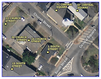
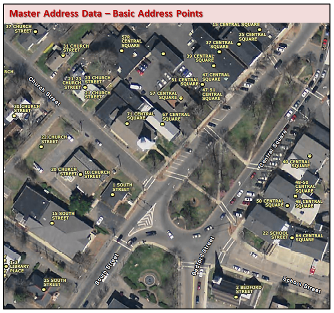
This export is considered "basic" because values such as street name and town name have been added as attributes of the point geometry, the geometry represents simple points instead of more complex multipoints, and it has a reduced number of address record fields compared to the information in the full MAD.
The statewide address points feature class is named MAD.MAD_ADDRESS_POINTS_GC in MassGIS' ArcSDE database (VTP and VWP instances). It is refreshed weekly.
Point Data
Each week an automated Python script runs these processes to refresh the MAD.MAD_ADDRESS_POINTS_GC layer in MassGIS' Oracle enterprise geodatabase (VTP instance):
- Export the spatial view MAD.MADV_ADDRESS_POINTMC_STNM to a feature class. The view was created using the geometry from MAD.MAD_ADDRESS_POINTM_CENTROID and records from MAD.MAD_MASTER_ADDRESS, MAD.MAD_MASTER_STREET_NAME and MAD.MAD_MSAG_COMMUNITY_POLYM
- Identity all non-Boston points with HERE Zip Codes to assign a postal name. Data from Boston are populated with postal names.
- Combine with copy of Boston points (MAD.BOSTON_ADDR_PTS)
- Copy the final layer to the VWP instance
The MAD.MAD_ADDRESS_POINTM_CENTROID feature class represents a structure (building) weighted aggregate midpoint where they exist. In parcels without structures, the point is located at the parcel centroid. In many cases points at a single location will link to multiple address records in MAD.MAD_MASTER_ADDRESS (such as for condominiums). This one-to-many relationship is modeled as "stacked" points when the spatial view is exported, creating several points with the same X,Y coordinate pair.
For a detailed description of how points are created and maintained in the MAD see the "Methodology" section on the Basic Address Points page.
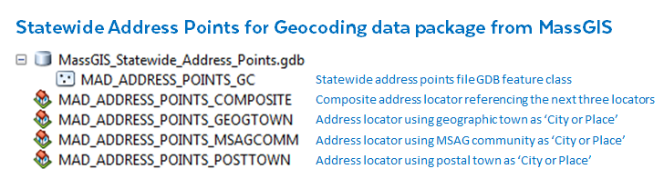
Address Locators
These locators use the statewide points as the reference data, which provide results more accurate than those from most linear geocoding sources such as street centerlines. MassGIS distributes sets of locators for use in ArcMap and ArcGIS Pro. See the section "Town vs. Community and Neighborhood Names" on the Basic Address Points page for details on and illustrated examples of the different types of city or place names.
Locators for ArcMap
MassGIS distributes four address locators that may be used in address matching processes in ArcMap:
- MAD_ADDRESS_POINTS_COMPOSITE - Composite locator that references the other three. Most useful for lists of addresses that may use different types of a city or place name. The geocoding process will use all three locators to find matches. The three component locators use the US Single House with Subaddress style. Each is rebuilt as part of the weekly update processing.
- MAD_ADDRESS_POINTS_GEOGTOWN - Uses the 351 official municipality names (GEOGRAPHIC_TOWN) as the 'City or Place' field, e.g. "BARNSTABLE", "BOSTON"
- MAD_ADDRESS_POINTS_MSAGCOMM - Uses Master Street Address Guide (MSAG) Community name (COMMUNITY_NAME) as the 'City or Place' field, e.g. "HYANNIS", "BRIGHTON"
- MAD_ADDRESS_POINTS_POSTTOWN - Uses postal town name (PC_NAME) from the HERE ZIP Codes data as the 'City or Place' field, e.g. "HYANNIS PORT", "ALLSTON". Most MSAG community names are also postal towns, but there are many more ZIP Code names than MSAG names.
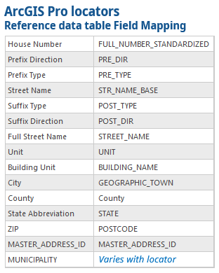
Locators for ArcGIS Pro
MassGIS distributes the following address locators that may be used in address matching processes in ArcGIS Pro:
- ArcPro_Address_Point_Geotown - Uses the 351 official municipality names (GEOGRAPHIC_TOWN) as the 'City or Place' field, e.g. "BARNSTABLE", "BOSTON." Includes unit (building, floor, suite, etc.) information.
- ArcPro_Address_Point_Geotown_No_Unit - Uses the 351 official municipality names (GEOGRAPHIC_TOWN) as the 'City or Place' field, e.g. "BARNSTABLE", "BOSTON." Does not Include unit information.
- ArcPro_Address_Point_MSAGComm - Uses Master Street Address Guide (MSAG) Community name (COMMUNITY_NAME) as the 'City or Place' field, e.g. "HYANNIS", "BRIGHTON." Includes unit (building, floor, suite, etc.) information.
- ArcPro_Address_Point_MSAGComm_No_Unit - Uses Master Street Address Guide (MSAG) Community name (COMMUNITY_NAME) as the 'City or Place' field, e.g. "HYANNIS", "BRIGHTON." Does not Include unit information.
- ArcPro_Address_Point_Postaltown - Uses postal town name (PC_NAME) from the HERE ZIP Codes data as the 'City or Place' field, e.g. "HYANNIS PORT", "ALLSTON". Most MSAG community names are also postal towns, but there are many more ZIP Code names than MSAG names. Includes unit (building, floor, suite, etc.) information.
- ArcPro_Address_Point_Postaltown_No_Unit - Uses postal town name (PC_NAME) from the HERE ZIP Codes data as the 'City or Place' field, e.g. "HYANNIS PORT", "ALLSTON". Does not Include unit information.
- ArcPro_Address_Points_All_Composite - Composite locator comprising the six locators with and without units.ArcPro_Address_Points_Composite - Composite locator comprising the three locators with units.
- ArcPro_Address_Points_No_Unit_Composite - Composite locator comprising the three locators without units.
The "ArcPro" locators listed above are compatible in ArcGIS Pro 3.5 and above. Locators backwards compatible to ArcGIS Pro 3.0 have "_30" in their file names.
Note on locators with units: Units are returned in geocoding results only if you search for them specifically. For example, the address "1 Ashburton Pl, Boston, MA" will not return units, but "1 Ashburton Pl, Rm 1, Boston, MA" should return candidates with that unit. According to Esri, this is by design with Pro locators. If you do not have units in your input addresses, we recommend using the "No_Unit" locators. A No_Unit version is provided for each of the different area name locators for those geocoding exercises that do not require a unit value to be returned. The No_Unit locators reduce the complexity of the match between input addresses and the source MAD data and can improve results in regards to reduction in the number of missed addresses and false positive results.
Attributes
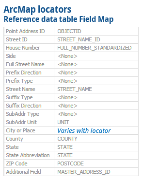
The statewide address points feature class contains the following fields:
| Name | Type / Length | Description |
|---|---|---|
| OBJECTID | OID / 38 | ESRI geodatabase unique ID for each feature. |
| CENTROID_ID | String / 20 | Unique ID of the centroid point, composed of its concatenated XY integer coordinates in MA State Plane meters. Links to associated address multipoints' ADDRESS_POINT_ID in MAD_ADDRESS_POINTM. |
| FULL_NUMBER_STANDARDIZED | String / 30 | Standardized address number of the address. May be a range and/or contain characters indicating prefixes and suffixes. |
| ADDRESS_NUMBER_PREFIX | String / 6 | Prefix to address number, or prefix to first number if the full address number is a range (e.g. 'A' in 'A2'). |
| ADDRESS_NUMBER | Long Integer / 10 | Integer portion of address number, or first number if the full address number is a range. |
| ADDRESS_NUMBER_SUFFIX | String / 6 | Suffix or fraction associated with the address number or associated with the first number if the full address number is a range (e.g. 'A' in '14A-14D' or '1/2' in '6 1/2'). |
| ADDRESS_NUMBER_2_PREFIX | String / 6 | Prefix to second address number if the full address number is a range (e.g. 'B' in 'A2-B2'). |
| ADDRESS_NUMBER_2 | Long Integer / 10 | Integer portion of second address number when the full address number is a range (e.g. 12 in '10-12') |
| ADDRESS_NUMBER_2_SUFFIX | String / 6 | Suffix or fraction associated with the second address number if the full address number is a range (e.g. 'D' in '14A-14D' or '1/2' in '6-6 1/2'). |
| STREET_NAME | String / 80 | Standardized street name. |
| FLOOR | String / 30 | Standardized value for the subaddress portion of an address representing a 'Floor' designation (e.g. '3' in 'BLDG A, FLR 3, UNIT 1'). |
| UNIT | String / 40 | Standardized value for the subaddress portion of an address representing a 'Unit' designation (e.g. '1' in 'BLDG A, FLR 3, UNIT 1'). |
| MASTER_ADDRESS_ID | Long Integer / 10 | Unique ID for a standardized address record. Generated via sequence and trigger. |
| STREET_NAME_ID | Long Integer / 10 | ID associated with the standardized street name of the input street. Generated via sequence and trigger. |
| REL_LOC | String / 80 | Standardized location-style information relative to either the address, the street referenced by the address, or both. Common values include 'OFF', 'REAR', 'NEAR', 'BEHIND', etc... |
| SITE_ID | Long Integer / 10 | ID that links to MAD_SITE_NAMES where a site, feature, landmark, or place name is stored if it is a part of the address. |
| BUILDING_NAME | String / 100 | Building designation or formal building name if it has one (e.g. 'A' from 'BLDG A, UNIT 1', or 'MUGAR SCIENCE CENTER'). |
| GEOGRAPHIC_TOWN_ID | Short Integer / 5 | TOWN_ID of the municipality in which the address is physically located. Should match the GEOGRAPHIC_TOWN_ID (1-351) of any associated address multipoint. |
| COMMUNITY_ID | Long Integer / 10 | ID that links to the MSAG Community name from 911. |
| COMMUNITY_NAME | String / 30 | Name of the MSAG community. |
| GEOGRAPHIC_TOWN | String / 25 | Official municipality name. |
| POSTCODE | String / 10 | Address 5-digit ZIP Code (likely derived from ZIP+4 and MSAG/street name lookup or HERE data, not necessarily the address' original source material). |
| PC_NAME | String / 35 | Neighborhood name representing a sub-community location of the standardized street name. Adds an additional measure of geographic accuracy/uniqueness, especially for duplicated street names in a given MSAG community. |
| COUNTY | String / 35 | The two-character state abbreviation. |
| STATE | String / 2 | The two-character state abbreviation. |
| SHAPE | ST Geometry | User defined Oracle data type for spatial data. Works in conjunction with ST_GEOMETRY_SHAPELIB_PKG to provide enhanced querying capabilities in Oracle. |
Reporting Errors and Omissions
Address assignment is a responsibility of municipal government. MassGIS cannot update the MAD unless the update comes from an appropriate municipal source. If users have address information that is not included in this product or they see errors in the data, they should contact the department in the relevant municipality responsible for tracking official addresses and for distributing address updates. Refer to a List of Address Authority Departments in each city and town and visit the MA City and Town websites list for how to contact individual municipalities. If the address error or omission is confirmed by the municipality, the community’s addressing authority should notify MassGIS. Updates from municipalities are incorporated into the MAD and will appear in future address file downloads. All municipalities have been contacted concerning how to notify MassGIS of new or changed addresses as part of ensuring all their addresses are included in the NextGeneration 911 system. If the addressing authority is not familiar with how to notify MassGIS of new addresses or address errors, they can ask MassGIS how to submit this information by sending email to massgismail@mass.gov.
Maintenance
MassGIS is actively updating these data and the downloadable files are refreshed weekly.
Related Data
| Last updated: | May 11, 2026 |
|---|