Following a planning study begun in 2016 and completed in 2018, the Department of Conservation and Recreation (DCR) has partnered with the City of Cambridge and the Town of Watertown to implement several improvements while planning for others.
Short-Term Improvements
DCR has already begun to implement the short-term improvements laid out in the planning study. In 2018, the agency:
- Lowered the speed limit on Fresh Pond Parkway to 25 miles per hour.
- Painted new pavement markings where needed and appropriate.
- Installed direct-read speed indicators along the parkway.
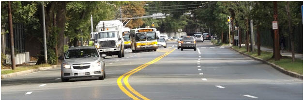
- Coordinated with the City of Cambridge to create a bus queue jump-lane inbound at Mount Auburn Cemetery. DCR made improvements to the intersection of Mt. Auburn Street and Coolidge Avenue, including the installation of a bus-only traffic signal, which turns green for the bus first. This transit improvement has measurably improved efficiency for riders of the 71 and 73 bus routes.
In 2020, DCR plans to undertake the next round of improvements in keeping with the recommendations of the planning study. These include:
- Placement of a curb extension on Gerry’s Landing Road at the intersection with Coolidge Avenue to shorten this pedestrian crossing.
- Installation of new bicycle pavement markings on Mount Auburn Street where it crosses Gerry’s Landing/Fresh Pond Parkway to strengthen the east-west bicycle connection along Mount Auburn Street.
- Placement of new pavement markings at the Mount Auburn Street intersection with the parkway to formalize lane use and improve safety.
- Further improvements to the traffic signal operation at Mt. Auburn Street and Coolidge Avenue to improve efficiency and reduce queueing.
Long-Term Improvements
DCR plans to make improvements to the Fresh Pond Parkway corridor in alignment with the goals of the 2016 planning study. Improvements will be made to ensure that the successful transit improvements are held harmless. DCR continues to coordinate with MassDOT and other state agencies to determine the best mechanisms to fund these improvements. Long-term measures for the corridor include:
- Improvements and reconfiguration of the intersections at Mount Auburn Street/Fresh Pond Parkway and Mount Auburn Street and Brattle Street.
- Additional improvements to the signalized pedestrian and bicycle crossings.
- Traffic calming measures, such as major geometric changes to the intersection of Mount Auburn Street and Fresh Pond Parkway.
- Coordination with the MBTA to adjust bus catenaries to allow Fresh Pond Parkway intersection reconfiguration.
- The creation of a separated bicycle connection between Mt. Auburn Street and the river.
The Mount Auburn Street Corridor Planning Study
The Mount Auburn Street Corridor Planning Study has served as the foundation of the improvements being undertaken for Mount Auburn Street and Fresh Pond Parkway/Gerry’s Landing Road. Begun in May of 2016 and finalized in mid-2018 with the publication of the project’s final report, the Department of Conservation and Recreation (DCR) conducted the Mount Auburn Street Corridor Study to develop short- and long-term recommendations for the improvement of Mount Auburn Street and portions of the adjoining roadways. The objectives of the project were to identify improvements to create safe and welcoming conditions for bicyclists and pedestrians, particularly between the Charles River and abutting neighborhoods, and to improve conditions for transit riders, all while maintaining vehicular access particularly to local businesses and Mount Auburn Hospital. The study addressed the Mount Auburn Street Corridor from Belmont Street in Watertown to Traill Street in Cambridge and Fresh Pond Parkway/Greenough Boulevard from Huron Avenue to the Eliot Bridge.
At the time of the study, Mount Auburn Street between Belmont Street and Fresh Pond Parkway had two travel lanes in each direction and carried approximately 19,000 vehicles per day. Fresh Pond Parkway has two travel lanes in each direction north of Mount Auburn Street and carried approximately 34,000 vehicles per day. The 71 and 73 MBTA bus routes carried 12,000 weekday daily riders, representing as much as one-third of total people traveling through the corridor at the time, many of whom walked or cycled to access transit service. At the time of the study’s launch in 2016, both Mount Auburn Street and Fresh Pond Parkway were noted as significant gaps in Cambridge’s current cycling network.
The study was conducted by a consultant team led by Howard Stein Hudson (HSH), supported by Kittelson Associates, Crosby | Schlessinger | Smallridge, Fort Hill Companies, and Bryant Associates. Crucial to the successful completion of the work was a dedicated stakeholder group which met seven times over the course of the project. This group was composed of over 40 members, including representatives of local government, area businesses, residential neighborhoods, and applicable advocacy organizations. In addition to several stakeholder group meetings, four public meetings were held, and additional community input was gathered through community pop-up sessions and a web-mapping citizen engagement tool.
The short- and long-term recommendations that are the product of this planning process are contained within the final Mount Auburn Street Corridor Study Report. The individual chapters of the Report can be downloaded below.
Final Report
- Background
- Building of the Stakeholder Group
- Existing Conditions
- Defining the Issues and Established Shared Goals
- Design Development and Concepts
- Short Term Design Concept
- Mount Auburn Report - Long Term Design Concept
- Long-term Design Concept Part 2
- Conclusion
- Appendix A - Traffic Counts
- Appendix B- SIDRA Roundabout Analysis
- Appendix C – VISSIM Outputs
It is the agency’s goal to implement many of the Study Report recommendations through the measures described below:
Stakeholder Meeting Materials
January 10, 2017: Presentation Minutes
November 1, 2016: Presentation Minutes
September 15, 2016: Presentation Minutes
August 18, 2016: Presentation Minutes
July 21, 2016: Presentation Minutes
June 23, 2016: Presentation Minutes
May 5, 2016: Presentation Minutes
Public Meeting Materials
February 4, 2020: Meeting Notice Presentation Hand-Out
December 13, 2017: Notice Presentation
January 31, 2017: Notice Presentation Part 1 - Part 2 Minutes
November 14, 2016: Notice Presentation Draft Roll Plans Minutes
June 1, 2016: Notice Presentation Meeting Notes
Questions/Concerns?
If you have questions or concerns or wish to subscribe to a listserv to receive periodic project updates, please email Mass.Parks@state.ma.us or call 617-626-4973.