Recommendations
Make Trail Accessibility Information Clear and Available to All
Every user comes to a trail with different accessibility needs and desires. Potential users need clear, consistent, and reliable information about trail conditions in order to make informed decisions about where and how to recreate. However, current information on accessible trails is fragmented, inconsistent, incomplete, and often inaccurate—making it difficult for users to know what to expect.
To address this, the report recommends establishing a standardized statewide trail rating system, supported by consistent data collection, clear public guidance, and better staff training. Accessibility information should be available both online and at trailheads, using plain language and inclusive formats.
Providing transparent, accurate information for all trails—including those that do not meet accessibility standards—will enable users to plan confidently and expand access for a wider range of people.
Recommended Actions
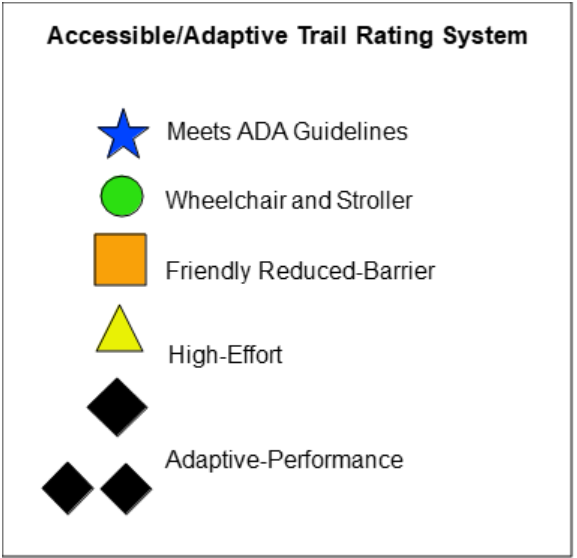
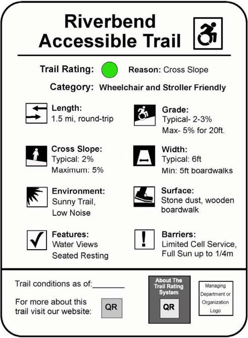
- Adopt a numerical, icon-based, or name-based statewide trail accessibility rating system to be utilized by all state properties and for trails planned, built, or upgraded with the use of state-provided funds. Explore opportunities to coordinate with regional or national partners. (See Appendix C) [Advisory Council, All Actors]
- Publish a guidance document for land managers and trail stakeholders on how to rate, classify, and sign their trail using the statewide trail accessibility rating system. Include guidance on submitting ratings and classifications that includes detailed trail access information (TAI) to a centralized trails inventory. (These metrics could also be used as a reporting requirement for trails designed/planned, built/ upgraded, or maintained with state funds.) [Advisory Council, State Agencies]
- Ensure accessibility ratings and trail access information (TAI) are integrated into any state-wide or regional trail inventories. [State Agencies, Regional Planning Agencies, Municipalities]
- Consider shared use of the High-Efficiency Trail Assessment Process (HETAP) tool between trail organizations to expand trail assessment capabilities, combined with regular training opportunities. Alternatively, provide training for a set of individuals to conduct assessments using the tool across the state. [State Agencies, Large Land Trusts]
- Develop a concise resource—a web page or one-page handout—to help trail managers and staff confidently welcome visitors of all abilities. The resource should summarize regulations, legal requirements, and other tools or guidance that support safe and positive trail experiences for visitors. [Advisory Council]
Implement Shared Standards and Policies for Data Collection and Use of Digital Mapping and Other Applications
Consistent and accurate trail information requires a standardized framework for how trail data is defined, collected, and shared. Establishing common data standards allows information to be reliably gathered, updated, and applied across mapping tools and digital platforms.
The report recommends creating a statewide inventory of accessible trails with searchable, filterable data on key features such as slope, surface, and amenities. Existing efforts, such as a statewide trail mapping initiative, provide a foundation for this system, which could also integrate with widely used platforms like Google Maps.
Ongoing coordination, funding, and data reporting—particularly through state-funded projects and planning processes—will be essential to maintain and expand this system over time.
Recommended Actions
- Adopt a technical data standard for accessible trails that reflects the design/ construction standards described in action 2.1.1. This data standard should define a “schema” to enable digital representation of accessible trails information such as trail slope, width, surface type, ADA parking, and restrooms, and to support the collection, verification, and digital publication of information about accessible trails to an online map and/or open data platform.
- Develop and maintain a statewide accessible trail inventory and database by compiling and aggregating existing sources of trails information and by collecting new information where relevant trail attributes are missing. This database should build on existing efforts like the MassGIS Statewide Trails Database, and should be maintained by dedicated GIS and database staff. Ensure that projects funded by various state grants & programs provide trail data consistent with these standards.
- Publish an accessible trails web map and data hub website with information available for bulk download, via application program interface (API), and made usable via official and third-party web tools, such as a mapping system and/or app that uses the trail rating system. The web map should include search and filtering tools that allow online users to filter trails not only by accessibility “rating/ category” but also by specific key information relevant to accessibility, such as “max grade”, “trail width”, “trail surface material”, “availability of ADA parking”, “availability of ADA bathroom” etc.
Expand Awareness of Accessible Trails and Their Benefits
Lack of awareness is a major barrier to equitable access to trails—not only among potential users, but also among decision-makers who influence funding and policy. Building accessible trails is not enough; people need to know they exist and understand their value.
The report recommends targeted outreach through trusted partners such as healthcare providers, schools, and community organizations, along with inclusive and representative marketing. Raising awareness of the public health, economic, and social benefits of accessible trails can also strengthen support among policymakers and unlock new funding opportunities.
Improving awareness among both users and decision-makers is essential to building long-term support and sustaining investment in accessible trails.
Recommended Actions
- Promote the numerous benefits of accessible trails to decision-makers and the general public to build support and awareness. [Advisory Council, Advocates]
- Advertise the presence of accessible trails through hospitals, rehab centers, schools, senior centers, disability commissions, adaptive sports and recreation non-profits, and public transit. [Regional Planning Agencies, Municipalities, State Agencies, MOD]
- Continue the dialogue with the Department of Environmental Protection, DCR, Legislature, and other relevant stakeholders to raise awareness about trails, and especially accessible trails, as a resource for public good. [Advisory Council, State Agencies, Legislators, Advocates]
Why Information Matters
Accessible trails are only useful if people can find them, understand them, and trust the information provided.
Today, trail information is often inconsistent, incomplete, or outdated—making it difficult for users to know what to expect or whether a trail meets their needs. This is especially critical for people with disabilities, for whom uncertainty can be a barrier to participation.
Clear, accurate, and standardized information allows users to:
- Plan visits with confidence
- Choose trails that match their abilities and preferences
- Avoid unsafe or inaccessible conditions
At a system level, consistent data also supports better planning, investment, and accountability.
In short, accessible trails require accessible information—without it, even well-designed trails remain out of reach for many users.