This chapter discusses access management techniques that apply to highways and streets. The chapter describes the context in which access management is commonly used and MassDOT’s role in managing access, including guidelines and driveway design. The chapter then describes other access management techniques and land-use strategies that local jurisdictions can use as part of an access management program.
Access management applies roadway and land-use techniques to preserve the safety, function, and capacity of transportation corridors. The objective is to ensure roadway safety and efficient operations while providing reasonable access to the adjacent land uses. Access management can also improve the environment for pedestrians, bicyclists, transit users and motor vehicles in all settings and on all roadway types by reducing and consolidating driveway conflict points.
In addition to the guidance provided in this chapter, the Transportation Research Board’s (TRB) Access Management Manual, 2nd Edition, and NCHRP’s A Guidebook for Including Access Management in Transportation Planning provide more information on developing access management programs, including:
- Principles and effects of access management
- Access management techniques and their potential advantages, disadvantages, and applications
- The interrelationship with land development and how access management is addressed in the context of comprehensive planning and land development regulation
- The rationale for spacing standards and how to choose appropriate standards for connections, signals, corner clearance at intersections, and interchange areas
- Information on the location and design of access features, such as driveways, medians, auxiliary lanes, and service roads
- Legal considerations that guide program development and implementation
15.1 Relationship to Context
Access management application varies according to the roadway context and functional roadway classifications. Access management can be an important component of new facility plans since the designer has more flexibility in the location and design of driveways. Designers can also apply access management techniques to retrofits of existing facilities; here, the designer can reduce the number and improve the characteristics of access to properties along the corridor through regulatory or negotiated processes. In Massachusetts, the majority of access management activities involve retrofits of existing facilities.
Area Types
Access management can be applied anywhere. It can be particularly helpful if an access management program is developed for an area prior to its development to systematically plan for access, or limits to access, along a corridor. Within “Rural Developed” and “Suburban” area types, development is often comprised of significant commercial development of medium-to-large-sized lots, which are favorable to an access management program. In other more urban area types (e.g., Village/Town Center and CBD), where constraints exist, there may be fewer opportunities to apply access management techniques.
Roadway Types
Access management describes a wide range of regulatory and design techniques to ensure that roadway facilities provide both access to property and regional mobility. Degrees of access control that influence access management, and their relationship to different roadway types, are described below.
Access Control
Access control defines the degree to which properties are connected to a roadway. The following degrees of access control are possible:
- Controlled access: This is typically applied to freeways or Major Arterials by limiting access to the roadway to interchange points or major intersections.
- Limited access: This is typically applied to Major and Minor Arterials where intersections are widely-spaced and driveway connections are limited (often to right-in, right-out operations or widely-spaced signalized intersections). Driveways to properties may be consolidated to limit connections to the roadway. Major intersecting streets may be signalized, converted to roundabouts, or grade separated with an interchange. Minor intersecting streets may be limited to right-turn in, right-turn out operations or may be grade-separated.
- Full access: This is typically applied to arterials or collectors by providing access to adjoining properties without restrictions on turning movements. Driveway spacing and other design guidelines are typically applied. Intersecting streets usually provide the full complement of turning movements.
- Uncontrolled: This is typically applied to Minor Collectors and Local Roads where access controls are not employed.
Access Management, Access Control, and Functional Classification
Often, access management plans are developed for arterial roadways that serve local and regional travel and freight movement as part of a corridor upgrade or planning study. Although most commonly applied to arterials, access management techniques are also applicable to collectors that carry higher speed, higher volume traffic. Access management tools are infrequently applied on local streets. Access management can be an integral part of planning for safety or addressing high-crash locations on all types of facilities.
Access management can improve the relationship between the adjacent land use and the functional classification of the road. The designer may have the ability to design access points to the facility that are consistent with the roadway’s functional classification, as described below:
- Freeways: Freeways are roadways with controlled access. Access is limited to interchange points, and intersecting roads are treated using one of the methods described in Section 15.3 under “Full Access Control Highways.”
- Major arterials: On major arterials, limited access or full access may be provided. Access management is an important element of the design, and driveway spacing and configuration should minimize impact to regional traffic flow. The designer should work with adjacent landowners to develop driveway spacing and layout consistent with the purpose of the roadway using the guidelines and tools discussed in this chapter.
- Minor arterials and major collectors: In most cases, full access is provided on minor arterials and major collectors. These roadways fall within the middle of the functional classification system and provide a combination of access to land and regional mobility. Access points are likely to be more frequent than on major arterials, and greater impedance to regional traffic flows is expected on these roadways. Nonetheless, the access management techniques remain important for these roadways, and the designer should meet the driveway spacing and corner clearance guidelines described in this chapter.
- Minor collectors: Full access or uncontrolled access is usually provided on minor collectors. Of the facilities in which MassDOT is typically involved, minor collectors provide the highest degree of land access. Parcel access is often more important than regional mobility on these roadways. As described above, however, benefits for all users can be obtained by providing well-designed access points.
- Local roads: Access is usually uncontrolled on local roads. The primary function of local roads is to provide access to the adjacent land use. Access and driveway design is usually performed to meet the guidelines of the local jurisdiction.
15.2 MassDOT's Role in Managing Access
Access management must consider road design principles as well as land-use planning principles to be effective. As such, it requires a joint effort between MassDOT and the appropriate communities. While MassDOT is responsible for providing a safe and efficient transportation network, local jurisdictions are responsible for orderly growth patterns that minimize the impacts of land use on the transportation system.
Access Guidelines
MassDOT has an active role in access management and is responsible for issuing permits for all new curb cuts and modifications to existing curb cuts on state-owned routes (MGL Chapter 81, Section 21). Design standards for the provision of access onto state highways have been in place for decades and have been updated several times.
MassDOT’s goal when reviewing and issuing access permits is to provide safe and efficient access while maintaining the highway’s safety and the operational integrity. Design reviews are also conducted to ensure that driveways are properly designed and maintain safety for all users.
The MassDOT District Highway Director is responsible for maintaining the function and operations of roadways with respect to access in their District. In this capacity, the District Highway Director has discretionary access permitting authority to permit or deny access if it is not designed adequately (through the District Permit Engineer). Details on the process for when access permits are needed and how they are obtained is available on the State Highway Access Permits page and from each MassDOT District Office.
MassDOT projects should provide well-designed access to the state highway system. An effective access management program requires a systematic approach that considers roadway classification, traffic volumes, multimodal users, speeds, and local land-use policies, as discussed in this chapter.
Monitoring, Reviewing and Responding to New Development
MassDOT’s Public/Private Development Unit (PPDU) monitors development proposals that may affect state highways. Many development projects require permits from MassDOT for access or indirect access to its facilities. The review and approval of development projects occurs at the local level, following local regulations expressed in zoning codes, development guidelines, and administrative procedures. MassDOT focuses on the safety and operational impacts to public ways. Larger projects exceeding the review thresholds included in state regulation are also reviewed under the Massachusetts Environmental Policy Act (MEPA) provisions.
Both local and MEPA development review procedures usually require assessing the impacts on nearby roadways of new development proposals. These transportation impact assessments (TIAs) often result in commitments for access design and offsite roadway improvements. The development project proponent should consult the Transportation Impact Assessment (TIA) Guidelines (2014) by the Executive Office of Transportation and the Executive Office of Environmental Affairs as well as other statutes, regulations, executive orders, or policy directives that govern roadway and traffic issues.
These review procedures, either under MEPA or local regulation, provide numerous opportunities for public review and comment on development projects and associated roadway improvements. Depending on the outcome of these review processes, MassDOT’s PPDU works with developers and their consultants to ensure that access points and offsite improvements are designed and constructed to meet standards, including the context sensitivity and multimodal, complete streets goals of this Guidebook. In many cases, the developer constructs roadway improvements once the designs are reviewed and approved by MassDOT and other responsible parties, such as the municipal planning, public works, or building departments.
Larger projects that require completing an Environmental Impact Report (EIR) by the Executive Office of Environmental Affairs also require a Section 61 Finding, which is issued by MassDOT relative to access, prior to the issuance of an access permit. The Section 61 Finding specifies the driveway access and offsite mitigation measures necessary for initial occupancy of the project. Additional mitigation measures and the construction timing of the measures relative to phased development of a project may also be specified in the Section 61 Finding to ensure that the anticipated development impacts do not adversely impact the transportation system.
Driveway Design
Driveways are points of access from public streets to private property and, therefore, are not intersections as defined in Chapter 6. However, the requirements for making turning movements between public streets and driveways are similar to the turning movements required at intersections. Driveways are intended for low-speed vehicle operation and may be designed with or without curb returns. If curb returns are present, corner radii should be designed for low speeds. Where higher speeds are required due to the nature of the public street or traffic volumes on the driveway (as in a commercial parcel), or where driveways fall within the area of a signalized intersection, design guidelines for intersecting streets, as discussed in Chapter 6, are applicable.
This section outlines guidance for five main aspects of driveway design:
- Driveway horizontal geometry, including the width, number of lanes, shape and dimensions of the entry/exit transitions, channelization, and angle
- Driveway intersections with pedestrian and bicycle facilities
- Driveway grading considerations
- Driveway spacing and consolidation
- Corner clearance
All driveways shall be reviewed by the District Traffic Engineer and shall be approved by the District Highway Engineer or District Highway Director.
Driveway Horizontal Geometry
Guidelines for typical, non-intersection driveway dimensions are provided in Table 15‑1. The table presents recommended maximum widths and recommended minimum right turn radii for different driveway types. Width is measured between the two points of tangency to the drive. Similar to intersection design, wide lane widths and excessively large radii can result in higher speeds and reduced safety for both pedestrians and bicyclists. Therefore, designers should seek to reduce driveway widths and corner radii as much as possible. New driveways on state-owned roadways should meet the guidelines in Table 15‑1. Existing driveways on state-owned roadways proposed for reconstruction should be assessed for feasibility of meeting the guidelines. Ultimately, the selection of design vehicles and their corresponding turning radii should guide driveway design.
| Land Use Category | Single-Lane Driveway Recommended Maximum Lane Width (Feet) | Two-Lane Driveway Recommended Maximum Lane Width (Feet) | Recommended Minimum Right Turn Radius (Feet) for Driveway with Curb Return |
|---|---|---|---|
| Small Residential (typically fewer than ten dwelling units) | 12 | 16 | 2 |
| Large Residential (typically more than ten dwelling units) | 12 | 24 | 12 |
| Commercial | 16 | 26 | 15 |
| Industrial | 20 | 40 | 30 |
Single-lane driveways are appropriate for two-way traffic for most single-family residential uses as well as for small clusters of residential units, such as free-standing apartments. For consolidated access to around ten dwelling units or greater, a two-lane driveway is likely appropriate.
For small, commercial uses with employee-only traffic (i.e., no retail customers or frequent visitors), a single-lane driveway is adequate. For commercial uses with retail customers and regular visitors, a two-lane driveway is preferable. Commercial properties are likely to require more context-sensitive design and may include additional access elements such as medians, signals, additional turning lanes, or multiple entries or exits. Industrial driveways typically serve properties receiving or sending out deliveries on larger trucks, and therefore will often require two lanes and larger turning radii. Commercial and industrial driveways may be designed as intersections in some cases. For more information on intersection design, see Chapter 6.
Driveways may be designed with curb returns or with flared transitions (without curb returns) between the driveway and edge of the roadway as shown in Figure 15-1 and Figure 15-2, respectively. Flared driveways should generally be reserved for lower-volume, lower-speed, single-lane residential driveways. The typical widths in Table 15‑1 still apply to flared driveways, but control vehicles may be more likely to encroach into the adjacent travel lane while turning from the roadway into the driveway.
Figure 15-1: Elements of a Typical Driveway with Curb Returns
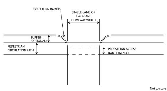
Source: MassDOT
Figure 15-2: Elements of a Typical Flared Driveway
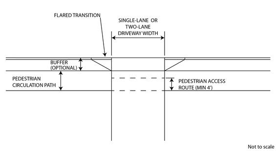
Source: MassDOT
The cross-section of the intersecting roadway influences the turning ability of a design vehicle, and therefore influences the determination of driveway widths and radii, as shown in Figure 15-3. For example, on roadways with wide shoulders, bicycle facilities, and/or sidewalk buffers, the effective turning radius will be larger than on a roadway with little to no shoulder or buffer, making narrower driveways and smaller corner radii more feasible. At higher volume driveways, the use of right-turn lanes can also make narrower driveways and smaller corner radii more feasible due to the deceleration they allow.
Figure 15-3: Effective Turning Radius
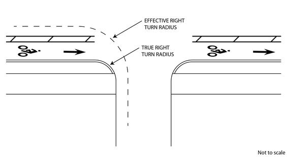
Source: MassDOT
A higher degree of control vehicle encroachment into adjacent or opposing lanes may be more acceptable for driveway designs than for intersection designs. Information on selecting design vehicles, typical encroachment by control vehicles, and more details on intersection design criteria are presented in Chapter 6. Upon reviewing the context of the driveway (which may not be purely residential, commercial, or industrial), the cross section of the intersecting roadway, the types of vehicles expected to access the parcel, and turning movement modeling, a designer may choose narrower or wider widths and/or smaller or larger turning radii than those presented in Table 15‑1.
The radii of a private driveway may not extend beyond the driveway owner’s side property line unless the affected abutter provides written approval of this condition. The radii may or may not be continuous through a pedestrian ramp, depending on ramp type, location, and grading.
When there is no buffer between the sidewalk and the roadway, designers should use a short curb return that provides a minimum 4’ pedestrian access route or an alternative transition type as shown in E.107.7.0 (flared) and E.107.8.0 (2’ curb corners). Figure 15-4 demonstrates the use of a short curb return. Refer to the MassDOT Construction Standard Detailsfor standard drawings of flared driveways (sidewalks through driveways without curb returns), driveways with minimum radii (sidewalk through driveways with curb returns 2’ curb corners), and residential driveways.
Figure 15-4: Elements of a Typical Driveway with No Buffer Between Sidewalk and Roadway
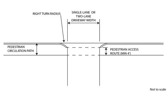
Source: MassDOT
Channelization
Medians may be appropriate in two-lane driveways to separate opposing directions of travel and to reduce excessive pavement area. Where medians are included, the recommended single-lane widths would apply to each side of the median (Figure 15‑5). A channelizing island may be designed to discourage left-turn movements in and/or out of a driveway (Figure 15‑6). Medians and channelizing islands may or may not serve as pedestrian refuges. For more information on medians, refer to Chapter 5, Section 5.5 (without refuge islands) and Chapter 16, Section 16.5 (with refuge islands).
Figure 15-5: Elements of a Typical Two-Lane Driveway with Median
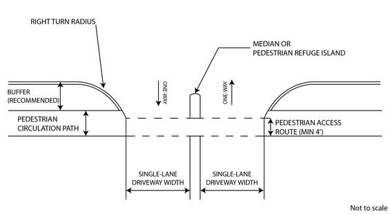
Source: MassDOT
Figure 15-6: Elements of a Typical Right-In/Right-Out Two-Lane Driveway
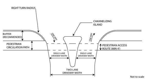
Source: MassDOT
Driveway Angles
Perpendicular driveways (90° angle) are preferred in all cases, but angled driveways (75° minimum) may be necessary in areas with right-of-way constraints or in select circumstances on one-way roads or divided highways. While designers should always consider sight distance when designing driveways, ensuring the appropriate view angles and intersection sight distance is especially important at angled driveways. Refer to the AASHTO Greenbook for more information.
Driveway Intersections with Pedestrian and Bicycle Facilities
Many driveways intersect with sidewalks, bikeways, side paths, and shared-use paths —especially those serving high-volume traffic generators, such as shopping centers, industrial parks, high turnover commercial uses, and other types of developments with similar traffic characteristics. Designers must consider these pedestrian and bicycle facilities in the geometric design of driveways and must design driveways to comply with requirements for pedestrian access routes and pedestrian ramps. For example, defining a visible driveway edge and minimizing the driveway width are two additional design objectives that benefit bicyclists and pedestrians. An accessible path of no more than 1.5 percent cross slope must be provided where a driveway crosses a sidewalk or a shared-use path. The minimum width of the accessible path is 4 ft for a sidewalk and 8 ft for a shared-use path. Where driveways are controlled with yield or stop control devices or traffic signals, detectable warning surfaces are required.
Refer to Chapter 5 for more information on pedestrian and bicyclist cross-section elements and refer to Chapter 11 for more information on shared use paths. Refer to the MassDOT Construction Standard Details for specific guidance on sidewalks through driveways with and without curb returns. Refer to the MassDOT Separated Bike Lane Planning & Design Guide for guidance on designing driveways across separated bicycle lanes.
Designers should strive to do the following to minimize the negative impact driveways have on pedestrian sidewalk travel:
- Minimize driveway widths, using single-lane driveways wherever possible. This reduces vehicular speeds, pedestrian crossing distances, and pedestrian exposure.
- Use single-opening driveways wherever possible to reduce conflict points.
- Maintain sidewalk grades and cross slopes to the extent possible, even if it means introducing breaks in driveway grades.
- A buffer between the sidewalk and roadway provides space for the driveway to ramp up to sidewalk level, making it easier to maintain sidewalk grades.
- For low-volume, unsignalized driveways, keep the sidewalk across the driveway at the same level as the adjoining sidewalk. Higher-volume driveways or driveways with signal control should be treated as intersecting roadways, with the sidewalk ramping down to the roadway surface. At these locations, standard ramp design practices apply.
- Designers should consider the design of an individual driveway within the context of the corridor to avoid varying the level of successive pedestrian crossings across adjacent driveways.
- Continue the sidewalk paving material across the driveway, rather than maintaining continuity of the driveway paving material across the sidewalk, especially when the sidewalk across the driveway is at the same level as the adjoining sidewalk. Where the paving materials are the same, the sidewalk should be outlined with joints or saw cuts across the driveway.
Driveway Grading Considerations
Designers should avoid profiles that allow the underside of vehicles to drag or hang-up. When establishing vertical alignments, designers must consider limitations on sidewalk cross slopes to design for all pedestrians, including those with disabilities. Also, designers should check profiles to make sure that they are not creating drainage problems. See NCHRP Report 659: Guide for the Geometric Design of Driveways for more information on driveway vertical alignment elements.
To allow reasonable entrance and exit speeds without causing vehicle under-ride and edge clearance problems, the vertical profile of the driveway cannot exceed certain limits. The maximum grade from the roadway edge to the edge of the pedestrian access route is 15 percent, as shown in Figure 15‑7. Vertical curves at least 10 ft in length may be used to connect the tangent slopes. Refer to the MassDOT Construction Standard Details for more information.
Lastly, designers must take into account the onsite profile of the driveway, even if outside of the project limits.
Figure 15-7: Example of a Driveway Vertical Profile Design
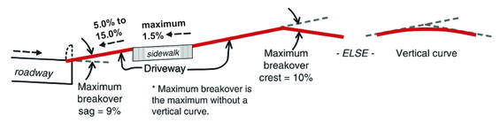
Source: Adapted from NCHRP Report 659: Guide for the Geometric Design of Driveways, Exhibit 5-75
NCHRP 659 indicates three types of control for the design of driveway profiles:
- Physical controls: Maintain enough clearance so the undersides of vehicles do not drag on the roadway or driveway surfaces.
- Operational controls: Vertical alignments should allow convenient and safe entry with minimal conflicts. To achieve this, changes in grades must not be too abrupt.
- Drainage controls: Profiles should not create undesirable drainage patterns.
Physical Control
Vehicles can drag on crest or sag curves along driveway profiles while entering or exiting driveways, as shown in Figure 15‑8. Any excessive grade change between roadway cross slopes and driveway grades, or between successive driveway grades can cause the underside of vehicles to scrape on the pavement. Vehicles with low ground clearance and/or long wheelbases are especially susceptible to this type of conflict. Software packages for modeling design vehicles now allow users to check vertical alignments and digital terrain models for under clearance conflicts and are useful in identifying and mitigating potential under clearance issues.
Figure 15-8: Geometry of Ground Clearance Dragging
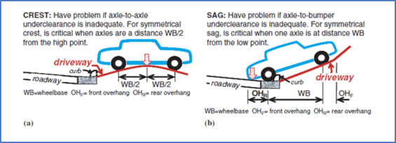
Source: NCHRP Report 659: Guide for the Geometric Design of Driveways, Exhibit 5-65
Operational Control
Research on driveways with visible scrapes suggests that under-clearance conflicts are more common on driveways with sag breakovers of ~10% and crest breakovers of ~10%. Vehicles enter and navigate driveways with excessive breakovers more slowly than driveways with flatter profiles. Slow speeds reduce the capacity of driveways and may result in crashes related to speed differentials between the mainline traffic flow and driveway traffic. However, slower operations may be desirable in areas with a high presence of people walking and biking.
Drainage Control
Key drainage considerations include ensuring that surface runoff from the roadway does not inundate the sidewalk or spill onto private property, or that debris and sediment-laden water from private property wash on to the roadway. It is also undesirable for ponding water to cover the driveway, making it difficult for motorists to identify the edges of the driveway. The installation of flared driveways can sometimes help to reduce drainage issues that are more common at driveways with curb returns.
In rural areas, where an open channel is used for roadside drainage, the channel should intersect the driveway at a 90-degree angle. The driveway side slope, including the pipe end section for the channel, should not exceed 1:6 and, preferably, will be 1:12. If construction will make significant changes on unpaved driveways, it may be necessary to pave the surface for proper drainage and erosion prevention. In all cases, the driveway should be paved to a point shown on the construction plans or established in the field by the District Permit Engineer.
Driveway Spacing and Consolidation
Separating conflict areas is an effective way to improve pedestrian, bicyclist, and vehicle safety. Extensive safety studies have confirmed that crash rates increase as the space between unsignalized access points decreases. This is especially true for commercial entrances and exits. Vehicles entering or leaving the road at driveway locations generally operate at slower speeds than the prevailing traffic, which increases crash potential and slows roadway travel. Managing driveway spacing often enhances operations and safety for the entire corridor.
Generally, there should be no more than two driveways for any one property unless there is a clear necessity for more access points. Minimum driveway spacing guidelines for constructing new driveways are based on posted speed limits and roadway type. They must consider:
- Stopping and intersection sight distances
- The functional areas of upstream and downstream intersections
- The influence of right turns on through traffic
- Egress capacity
TRB’s Access Management Manual, 2nd Edition presents detailed spacing guidelines for the various roadway types and environmental conditions, as summarized below:
- Functional area: All access points, signalized and unsignalized, have functional areas that often extend beyond the immediate physical intersection. This area is comprised of auxiliary lane vehicle storage (or queue) space and a decision/maneuvering distance approaching an intersection as well as merging and acceleration space departing an intersection, as illustrated in Figure 15‑9.
- Turn lane design: Driveway spacing must consider the interaction between successive right-turn lanes and their tapers.
- Safety: Separation of conflict areas improves vehicular, pedestrian, and bicyclist safety.
- Sight distances: Stopping sight distance, intersection sight distance, and decision sight distance are important considerations in driveway location and design. Chapter 3 discusses these design criteria.
- Right-turn conflict overlap: Driveways that are spaced too closely can impact through traffic operations when a driver must monitor more than one right-turn merging movement (called right-turn conflict overlap) or when upstream through traffic is required to brake and slow down for right-turning vehicles (referred to as the driveway’s "influence distance").
- Egress capacity: Closely-spaced driveways can interfere with each other and restrict egress capacity. This can be a result of increases in decision-making time and the influence of vehicle maneuvering and acceleration at adjacent access points.
Figure 15-9: Intersection Functional Area
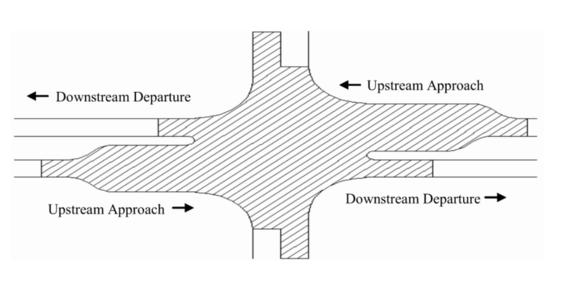
Source: MassDOT
Ideally, driveway spacing should be as far as possible, both from intersections and from other driveways. However, minimum spacing is often dictated by the right of parcel owners to gain street access and small parcel sizes in most highly-developed areas. For any driveway, whether flared or with a curb return, the minimum spacing from the property line is the radius of the curb return or the length of the flare so that the driveway opening at the roadway edge does not encroach on the adjacent property.
In certain areas, provisions need to be made for access to existing parcels of land. However, where multiple existing parcels develop as a single entity, as in the case of a shopping center, coordinated and shared access is preferable. Further, indirect or alternate access via secondary roads should be utilized to help implement the minimum standard. Finally, eliminating, consolidating, or reconstructing sub-standard access points should be incorporated into redevelopment projects and corridor improvements.
For new, residential subdivisions on major arterials, a consolidated point of access from an internal road network is preferable for all house lots. Ideally, new lots should not be provided direct access from major arterials. If lots front on arterials, designers should consider the advantages and disadvantages of loop driveways. Further, connections should be made to surrounding developments to facilitate bicycle and pedestrian travel as well as motor vehicle access.
Driveway closures are another way to eliminate conflicts with an arterial that has too many entering access points. As an alternative to closing or removing driveways, access at some locations can be restricted to right-in and right-out turns only to improve the overall safety of the arterial. Existing properties with multiple points of access onto major arterials are well-suited for this type of treatment.
Corner Clearance
Corner clearance is an issue related to driveway spacing that addresses the distance from roadway intersections to the nearest driveway entrance. A primary safety concern at or near controlled intersections is the reduction of interferences from side-street activity. Whenever practical, driveways should not be situated within the functional boundary of at-grade intersections (see Figure 15‑9). This can become a significant concern since inadequate corner clearance often results in backups from the intersection extending across driveway entrances and blocking ingress and egress.
Access management research has concluded that:
- Crashes appear to increase as corner clearances decrease
- Retrofitting corner clearances is both difficult and expensive
- A preferred proactive approach involves establishing a desired access location in conjunction with minimum frontage requirements that meets or exceeds the desired corner clearances
Corner clearance should be provided on the main roadway and on the intersecting side streets. It is applied to both the upstream approach and downstream departure side of an intersection. The standards for each roadway classification are quite different but wherever possible, driveways are to be set back a minimum of 50 ft with a recommended set back of 75 ft or more from a street corner. The set back is measured between the nearest edge of the driveway and the crossroad edge of pavement. A restrictive median can reduce corner clearance requirements. Additional distance may be needed to provide for increased vehicle queuing at signalized intersections. MassDOT guidance for recommended minimum corner clearances is provided in TRB’s Access Management Manual, 2nd Edition. Additional guidance for the minimum spacing of driveways from freeway ramps is provided in Chapter 7.
15.3 Access Management Techniques
A wide array of techniques can be used to manage roadway access. Appropriate measures vary according to roadway classification and existing context.
Turning Treatments
Removing turning vehicles from through lanes reduces the conflicts associated with the speed changes necessary to make turns (acceleration and deceleration). As such, turn lanes can improve safety and reduce delays at access locations. The majority of driveway-related crashes involve turns to or from the major road.
Left Turns
Left-turn lane designs allow for deceleration and storage of left-turning vehicles. They can provide safety and mobility benefits. For example, FHWA’s Proven Safety Countermeasures cites a study by Harwood et al., 2002, which found adding left-turn lanes at rural, two-way, stop-controlled intersections could reduce total crashes by 28-44 percent and fatal and injury crashes by 35-55 percent for three- and four-legged intersections.
In addition to safety benefits, left-turn lanes also benefit highway operations by delaying reductions to through traffic.
Several left-turn warrant methodologies have been developed that indicate the need for a turn lane based on the volume of left-turning vehicles as a function of the volume of opposing traffic. The National Highway Institute (NHI) suggests that such warrants may be appropriate for rural highways. The Highway Capacity Manual, 7th Edition, indicates that left-turn lanes are often provided at signalized intersections when left-turn volumes exceed 100 vehicles per hour (vph); dual left-turn lanes are often provided when volumes exceed 300 vph. AASHTO’s Policy on Geometric Design of Highways and Streets (2018) provides a table (Table 9-25) with guidance for providing left-turn lanes on two-lane roadways.
Various standards also exist regarding the length of left-turn lanes. The standards are generally a function of vehicle speed and traffic volume, and they are designed to allow turning vehicles to leave the travel lane, decelerate, and make the turning movement, which accounts for queuing at the intersection.
The length of turn lanes and tapers should be based on MassDOT left-turn warrants, intersection operations, and design criteria (see Chapter 6).
Right Turns and Use of Paved Shoulder
Similar warrants and design standards exist for right-turn lanes. Designers should consider right-turn lanes at new commercial entrances and the entrances to new residential subdivisions, where heavy turning volume is anticipated. Where numerous commercial or residential driveways exist in close proximity, designers should consider using an expanded right shoulder as a continuous turn/auxiliary lane. Adding right-turn lanes often shifts the roadway curb or edge and turning traffic may cross through bike lanes approaching intersections. Therefore, designers should ensure that such a treatment does not create an impediment to bicyclist or pedestrian access.
Median Treatments
Selecting appropriate median types can be critical to providing safe and efficient travel along major arterials. When selecting a median type, designers must often balance the need to provide access to adjacent properties, ensuring adequate throughput capacity and travel speeds, and meeting safety goals for intersections and corridors. Medians can also serve as pedestrian refuges at midblock and intersection crossings, helping to increase pedestrian safety and to facilitate two-stage crossings of wide intersections. For more information on pedestrian refuges, see Chapter 6.
By separating oncoming traffic and managing turning movements, non-traversable medians offer the most significant potential to improve roadway safety and operations. Non-traversable medians separate opposing traffic and effectively limit left-turns on roadways. Safety data have shown a 35% crash reduction attributable to installing medians (NCHRP Report 420). Wide, non-traversable medians prevent cross-over crashes, provide shelter for vehicles making left-turns from or to a side street, and provide refuge for pedestrians or bicyclists crossing the street. Where non-traversable medians necessitate right-in/right-out access, downstream intersections may need to accommodate U-turns or indirect intersection configurations may be necessary. For more information on intersection design and indirect intersection configurations, see Chapter 6.
In four-lane roadway sections, research has shown that selecting an appropriate median type depends on a number of factors, including number of access points, intensity of use at these access points, speed limit, presence of pedestrians, environment (developed, developing, rural), and the provision of adequate shoulders.
Two-way left-turn lane (TWLTL) roadway sections as a median treatment reduce crashes relative to undivided roadways without left-turn lanes, but the crash rate for a four-lane roadway with a non-traversable median is about 25 percent lower than for an equivalent roadway with a TWLTL. Several studies indicate that a TWLTL can be considered as an alternative to a non-traversable median without increased crash risk on roadways with volumes less than 17,500 to 24,000 vehicles per day (TRB Access Management Manual, 2nd edition). FHWA recommends considering a TWLTL in conjunction with a four-to-three road diet on roadways with volumes less than 20,000 vehicles per day (FHWA Road Diet Informational Guide, 2014). However, non-traversable medians are preferred on new multilane urban arterials, on rural multilane highways, on bypasses of urban areas, between closely-spaced roundabouts, and in areas with relatively high levels of pedestrian activity (TRB Access Management Manual, 2nd edition).
The design of a TWLTL section can minimize safety concerns if shoulders are provided and the width of the center left-turn lane is adequately sized. A 12-ft minimum (16-ft maximum) is suggested for a center two-way left-turn lane. The center turn lane is a shared space, so drivers tend to enter this area cautiously. Therefore, in areas with higher driveway densities, driver transitions into the turn lane will tend to occur at slower speeds. In these areas, the provision of a wider center turn lane (14-to-16 ft) is likely to result in fewer vehicles partially blocking the through travel lane. On long corridors and in locations with pedestrian crossings, TWLTL sections should be broken by median islands to prevent the lane being used as a passing or travel lane.
As discussed in Chapter 5 and Chapter 11, segments of non-traversable median interspersed with left-turn lanes is often preferable to a TWLTL section to provide pedestrian accommodation and reduce the perceived width of the street. Textured, colored pavements and other features can be combined with TWLTLs to improve their function.
Signal Spacing and Timing
The spacing of signalized intersections impacts safety and traffic operations. Management of signal spacing includes planning for the frequency of signals as well as the uniformity of their spacing. This technique is useful in managing access in some of the developed and developing corridors, particularly where several traffic signals already exist.
Optimal spacing depends on travel speed and cycle length. Research data indicate that as speed and cycle length increase, so does desired spacing. Refer to Chapter 6 for guidance on signal spacing. In all cases, signal timing should be coordinated to facilitate traffic flow.
Along developing sections of highways, development should be carefully planned to avoid the proliferation of new traffic signals and ensure that minimum spacing standards are maintained. Local zoning plays a significant role in managing the intensity of development and redevelopment that will occur.
As areas experience infill and redevelopment, existing driveways and circulation patterns should be reconfigured to complement the signal system to the maximum extent. This may involve closing existing driveways, rerouting traffic to secondary streets, and/or providing connections between parcels. Roundabouts also provide a technique for reducing the number of signalized locations (see the Guidelines for the Planning and Design of Roundabouts).
Inter-Parcel Connections and Internal Roadway Systems
Inter-parcel connections for both pedestrians and motorists can limit short trips on the main route. These often take the form of simple driveway and sidewalk connections between commercial sites so that traffic moving from one to the other need not access the arterial.
Large, residential developments can also be planned to provide a minimum number of access points on the main highway by internalizing private driveways on local subdivision streets, which then connect to a feeder road with direct and full access onto the main highway. Future growth of residential development can be accommodated by providing connections between developments and adjacent (potentially undeveloped) properties. This avoids single-entry cul-de-sacs serving each development and ensures that existing access points are used to the best and fullest extent.
In some communities, commercial and large residential developments are only allowed to have indirect access onto a major roadway or restricted right-in/right-out access, with the full access point on the side street. This is also done when a driveway is anticipated to have an adverse effect on traffic safety and operations.
Frontage Roads
A frontage road is a local street (one-way or two-way) that runs parallel to the main roadway and serves multiple parcels. A frontage road is an effective treatment to consolidate the number of access points (and, therefore, conflict points) on an arterial highway. As shown in Figure 15‑10, a frontage road can be designed with access from the side streets instead of the main roadway, or, in the case of the reverse frontage road, with two points of access from the main roadway.
A frontage road can be constructed without taking existing buildings fronting the roadway when the buildings are set back far enough to accommodate the roadway and maintain the minimum setback from the road required by zoning. However, more right-of-way may be required at major intersections where the frontage road ties into the main roadway.
Figure 15-10: Frontage Road Concepts
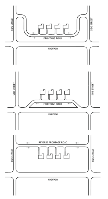
Source: MassDOT
Frontage roads can serve commercial development as well as residential access needs. When carefully designed to facilitate access and maintain signal operations, frontage roads can be a viable access management technique for large commercial developments.
Full Access Control Highways
When full access control is proposed for an existing highway or new freeway, each intersecting public or private way must be handled using one of the following options. The options listed below also apply to dedicated pedestrian and bicycle facilities.
- The intersecting facility can be dead-ended, thereby effectively terminating through traffic
- The intersecting facility can be re-routed to maintain connectivity, often as a frontage road
- The intersecting facility can be grade separated as either an underpass or an overpass, thereby maintaining through traffic but effectively terminating access to the intersecting highway
- The intersecting facility can be reconstructed as an interchange, thereby maintaining through traffic access to the intersecting highway
The importance of the continuity of the crossing road or the feasibility of an alternate route will determine whether a grade separation without ramps or interchange is provided. An interchange should be provided on the basis of the anticipated demand for access to the minor road. The decision to provide a grade separation without ramps rather than an interchange is often based on the following considerations:
- Lacking a suitable relocation plan for the crossroad, a highway-grade separation without ramps may be provided to maintain connectivity of low-volume roadways. All users desiring to access one facility from the other are required to use other existing routes. In some instances, these users may have to travel a considerable distance, particularly in rural areas.
- A grade separation without interchange ramps may be provided to avoid having interchanges so close to each other that signing and operation would be difficult. This approach eliminates interference with large major road interchanges and increases safety and mobility by concentrating turning traffic at a few points where it is feasible to provide adequate ramp systems. On the other hand, undue concentration of turning movements at one location should be avoided where it would be better to have additional interchanges.
- In rugged topography, the site conditions at an intersection may be more favorable for provision of a grade separation than an at-grade intersection. If ramp connections are difficult or costly, it may be practical to omit them at the structure site and accommodate turning movements elsewhere by way of other intersecting roads.
- Many times, partial interchanges are constructed initially because the traffic volumes do not support a full interchange, or the required right-of-way is not available when the interchange is first constructed. As time passes, however, the need for a complete interchange develops or the right-of-way is obtained.
15.4 Land Use Controls
Because access management deals with the relationship between transportation and land use, it requires cooperation between MassDOT and local government agencies. Local governments are encouraged to identify corridor preservation goals and address land-use access requirements in their comprehensive plans.
MassDOT, Regional Planning Agencies, and municipalities should cooperate carefully to manage access along the arterial roadway network. Local land-use plans and zoning ordinances that discourage highway-dependent development and sprawl support MassDOT’s goals to protect and preserve the safety and function of the Commonwealth’s transportation network.
Some recommendations included in this section fall under the purview of MassDOT, and others fall under control of the local governments. Consistent application of access management plans by all parties and across jurisdictional boundaries will produce greater success in preserving the highway system into the future.
The following sections describe approaches to managing access through land-use controls at the local level and are included as examples of steps local governments can take to improve the relationship between local land uses and the regional highway system.
Zoning and New Development
It is often necessary to revise local zoning standards to effectively implement access management and to improve the relationship between land use and access control. For example, it is helpful when zoning targets development in areas with good multimodal access, requires shared access along streets and highways, or encourages compact centers as opposed to strip development.
Subdivision regulations and local ordinances should require minimum lot frontages, dimensions, and street layouts that recognize the intended function of the roadway (traffic flow versus property access). The higher the roadway classification, the fewer the number of access points that should be provided along the roadway. A municipality’s ability to provide zoning restrictions that require minimum parcel frontages on important roadway corridors can significantly help enforce driveway spacing standards (i.e., minimum parcel frontage standard consistent with driveway spacing guidelines). Chapter 9 of the Access Management Manual, 2nd Edition provides guidance on land-use zoning, access controls, and subdivision site plan review processes that can help achieve the full benefit of an access management plan.
Highway Corridor Overlay District
One of the most effective tools in applying corridor-specific standards is the highway corridor overlay district (HCOD). This is a separate set of zoning regulations for parcels within a certain distance from a roadway, usually an arterial highway. An HCOD generally would not be used on lower-classification roadways. The ordinance implementing an HCOD contains additional regulations that are overriding, and in some cases, additive, to existing zoning regulations. HCODs involve standards governing access, visibility, and corridor aesthetics. They generally provide standards for the number and location of access points, inter-parcel connections, the size and location of signs, landscaping requirements, and buffer requirements.
Several communities within the Commonwealth have successfully implemented HCODs; however, they are often implemented in response to an already congested roadway. Elements of a model overlay district that was designed for incorporation into municipalities’ zoning ordinances are overviewed below.
Intent
The HCOD should state its intended effects, which are generally to enhance the safety, function, and capacity of designated highways. As major traffic routes, these highways represent significant community investments and contribute to public health, safety, and welfare. They provide access to jobs and schools, facilitate delivery of emergency services, support the movement of goods and services, and enhance economic development. Further, these corridors serve as a community’s first impression for visitors and the traveling public.
Applicability
The applicability of the HCOD should be clearly stated, as in the following example:
The HCOD shall also apply to redevelopment projects, as defined herein, regardless of whether such redevelopment requires site plan or subdivision review. As an overlay district, the HCOD shall complement the requirements of the underlying zone, which shall remain in effect. Wherever the requirements of the HCOD conflict with those of the underlying zone, the greater or more stringent standard shall apply.
To ensure adequate coordination with MassDOT regarding highway access management and traffic improvements, no site plan or subdivision plat shall be approved without a written finding from the MassDOT District Highway Director that the proposed roadway, driveway, and circulation systems are consistent with the Access Management Plan.
Access
The purpose of the HCOD is to manage vehicular and non-vehicular access. To achieve this goal, all site plans should include an access plan drawn to the same scale as the site plan. These plans should show the location and dimensions of all streets, driveways, crossovers, parking areas, access aisles, sidewalks, and any other relevant information. Access to the HCOD corridor should be provided by direct or indirect means, consistent with the following planning guidelines:
- Minimal number of access points.
- Required corner clearance of driveways from intersecting streets.
- Minimum sight distances along the highway for the design speed.
- Internal street layout and connections to the maximum extent feasible.
- Shared access to the maximum extent feasible.
- Good pedestrian and bicycle access to minimize conflicts with vehicular traffic.
- Pedestrian circulation systems that connect uses within individual projects to adjacent parcels and activity centers.
In order to promote the orderly retrofit of existing developments that do not conform to the requirements of the HCOD, while encouraging reuse of previously developed properties, redevelopment standards should be defined in the language of the ordinance. Given the varying conditions of existing development, some administrative flexibility is required when applying standards to redevelopment.
Traffic Impact Analysis
Within HCODs, traffic impact analyses are often required for developments generating a minimum number of average daily trips (for example, 1,000). The projected number of average daily trips should be based on trip generation rates as defined by the most recent publication of the Institute of Transportation Engineers “Trip Generation” or an acceptable substitute. In addition, a traffic impact analysis may be required for developments generating fewer daily trips when it is determined, in consultation with the MassDOT District Highway Director, that safety considerations warrant such analysis. The traffic impact analysis should identify level of service impacts of the proposed development and should be used to determine necessary improvements to support the development. The analysis should be conducted for the morning and evening peak commuter hours as well as for other peak hours applicable to the proposed use (e.g., a Saturday peak hour for retail development). At minimum, the impact analysis shall address the following:
- Definition of pedestrian, bicycle, and motor vehicle access
- Turn lane and access improvements
- Internal site circulation
- Shared access/access to adjacent sites
- Impacts to intersections and median crossovers
- Potential need for signalization or roundabouts
Required Improvements
Required improvements are determined in consultation with the MassDOT District Highway Director based on the traffic impact analyses for the proposed development. The developer shall be responsible for provision of the improvements.
Setbacks
In order to preserve and enhance highway safety and efficiency, setbacks are often specified in the HCOD’s language. Typically, setbacks are to remain free from all development, including buildings, parking areas, gas pumps, canopies, and similar structures and facilities. Where necessary to accommodate an approved circulation plan, access driveways are permitted within setbacks.
Setbacks can also be defined for the purposes of establishing streetscape improvements or to provide for future corridor widening when warranted.
Other Design Elements
To manage growth in a manner consistent with the intended traffic safety, operations, and corridor appearance objectives of the HCOD, design guidance for a number of other physical elements of the corridor, such as signage, lighting, and landscaping, are worth considering.
Well-planned and maintained signage, landscaping, and lighting will achieve several benefits in furtherance of this ordinance:
- Preserve and enhance traffic operations
- Enhance the pedestrian environment
- Preserve and enhance the visual quality of designated corridors
Site plans that include a landscaping plan drawn to the same scale as the site plan—and that show the location, size, and description of all landscaping materials in relation to structures, parking areas, and driveways—should be required.
Retrofitting Existing Development
Effective access management requires both retrofit and policy actions. A comprehensive access management plan will include recommendations for improve existing problem areas as well as requirements to ensure that new development does not degrade the future highway corridor function. The application of access management guidelines is not as straightforward on existing roadways. While some land uses may be replaced in the future development, a best-fit (or retrofit) approach must be used to try to achieve the access management objectives with existing uses.
For example, a new shopping center or residential development could provide an access road that connects to an existing church property that has poor access. This would allow for modification of the access to the church property. This is a proactive process that cannot be designed in advance but must be responsive as adjacent development occurs.
Major highway reconstruction projects should always review the potential for improvements to access management. A coordinated effort on the part of municipal officials and MassDOT is required to ultimately bring corridors up to desired standards.
15.5 For Further Information
- Access Management Manual, 2nd Edition, Transportation Research Board. Washington D.C., 2014.
- A Guidebook for Including Access Management in Transportation Planning, NCHRP Report 548, 2005.
- FHWA Road Diet Informational Guide, 2014.
- MassDOT Public/Private Development Unit
- MassDOT Separated Bike Lane Planning & Design Guide
- MassDOT Transportation Impact Assessment (TIA) Guidelines
- MassDOT Guidelines for the Planning and Design of Roundabouts
- Access Management Guidelines for Activity Centers, NCHRP Report 348, 1992.
- Impact of Access Management Techniques, NCHRP Report 420, 1999.
- Highway Safety Manual, 1st Edition
- Land Development Regulations that Promote Access Management, NCHRP Synthesis 233, 1996.
- Corridor Management, NCHRP Synthesis 289, 2000.
- Guide for the Analysis of Multimodal Corridor Access Management, NCHRP Research Report 900, 2018.
- Guide for the Geometric Design of Driveways, NCHRP Report 659, 2010.