Project Development is the process that takes a transportation improvement from concept through construction. There are several goals for this process:
- To ensure context sensitivity though an open, consensus-building dialogue among project proponents, reviewers, the public, and other parties
- To foster thinking beyond the roadway pavement and achieve the optimum accommodation for all modes
- To encourage early planning, public outreach, and evaluation so that project needs, goals and objectives, issues, and impacts can be identified before significant resources are expended
- To achieve consistent expectations/understanding between project proponents and those entities who evaluate, prioritize, and fund projects
- To allocate resources to projects that address local, regional, and statewide priorities and needs
Project delays and escalating costs are discouraging to everyone involved. Projects that are ultimately built but do not address needs as expected are also frustrating. This project development framework is designed to:
- Help proponents carry out projects effectively and efficiently
- Ensure that projects further MassDOT’s mission of providing a safe, reliable, robust, and resilient transportation system
Effective project partnerships are important throughout project development, and they require strong commitment and action from all involved. This may include MassDOT Highway Division or Federal Highway Administration (FHWA) staff, elected officials, local planning and public works professionals, citizens, or consultants. Real partnerships require ongoing relationships of trust and collaboration.
The project development process (“the process”) is structured to encourage public outreach throughout planning, design, environmental review, and construction so that those affected by transportation projects are in general agreement regarding the project’s need, the selected approach to meet this need, and the refinements to the project that result as the process evolves. This chapter contains an overview of the public outreach approaches and tools that can help establish an effective project development process.
This process is complemented by the inclusion of the project context as a basic design control. Flexibility for determining specific design elements that satisfy the project’s need and respond to the project’s context is inherent in the subsequent chapters of the PDDG.
2.1 Applicable Projects
Project proponents are required to follow the process described in this chapter whenever the MassDOT Highway Division (herein, “MassDOT”) is involved in the decision-making process. The project development procedures are, therefore, applicable to any of the following situations:
- When MassDOT is the proponent
- When MassDOT is responsible for project funding (state or Federal-aid projects)
- When MassDOT controls the infrastructure (projects on state highways)
In addition to MassDOT, many other agencies and organizations may be involved in a project. These procedures are written to be a useful resource for projects that are locally sponsored, funded, and reviewed, as well as for those that fall under the jurisdiction of other Massachusetts authorities. Projects with local jurisdiction and local funding sources are not required to follow this process. However, proponents designing projects on local roads may benefit from the project development steps outlined in this chapter and the design guidance found in subsequent chapters.
2.2 Project Development Process
Overview
The project development process is initiated in response to an identified need in the transportation system. It covers a range of activities extending from identification of a project need to a finished set of contract plans as well as on to construction.
The identified transportation need might include one or more of the following: a congestion problem, a safety concern, facility condition deterioration, a need for better multimodal accommodation, an environmental or resiliency enhancement, or an economic improvement opportunity. The development of solutions to address these needs often involves input from transportation planners, community leaders, citizens, environmental specialists, landscape architects, natural resource agencies, local public works or transit authority officials, permitting agencies, design engineers, financial managers, and agency executives. Solutions might target a single mode of transportation or address the range of road users, including pedestrians, bicyclists, transit operators, automobile drivers, and truckers moving freight and goods. It is important to engage the right team of people on the project from the beginning.
The sequence of decisions made through the project development process progressively narrows the project focus and, ultimately, leads to a project that addresses the identified needs. There should be ample opportunity for public participation throughout the process.
Figure 2-1: Overview of Project Development
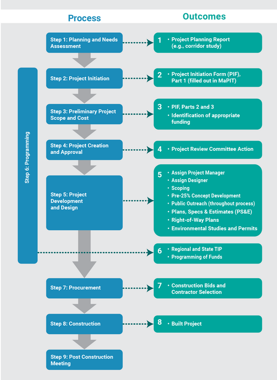
Source: MassDOT
Transportation decision making is complex and can be influenced by legislative mandates, environmental regulations, financial limitations, agency programmatic commitments, and partnering opportunities. Decision makers and reviewing agencies should be consulted early and often throughout the project development process so that all participants understand the potential impact these factors can have on project implementation. The typical MassDOT project follows a nine-step project development process, from problem identification to completion, as illustrated in Figure 2‑1:
Step 1: Planning and Needs Assessment
Step 3: Preliminary Project Scope and Cost
Step 4: Project Creation and Approval
Project Proponents
A MassDOT project is typically initiated by four general types of proponents:
- MassDOT Headquarters staff
- MassDOT District staff
- Another state agency staff, such as the Department of Conservation and Recreation (DCR)
- Official staff of a city or town in Massachusetts or their designated representative
MassDOT Headquarters Project Types
The project types initiated by MassDOT Headquarters staff generally originate from modernization needs (resiliency, mobility, safety) or the asset management systems for proper maintenance and repair of the Commonwealth’s roadway system. MassDOT proponents are typically managers of a specific class of infrastructure asset (e.g., bridges, pavement, etc.), a policy focus area (safety, traffic, resiliency, bicycle and pedestrian, etc.), or general funding programs (interstate maintenance, National Highway System (NHS) preservation, etc.).
MassDOT District Project Types
Project types initiated by MassDOT District staff generally originate from a specific need that is required for proper maintenance, repair, or modernization of the Commonwealth’s roadway assets or address a known issue. These needs can be from any policy focus area and cover the full breadth of transportation projects, including but not limited to:
- Safety improvements
- Bicycle, pedestrian, and transit accommodations
- Sidewalk reconstruction and repairs
- Streetscape improvements
- Roadway repair and/or repaving
- Construction of new roadways, new bridges, and replacement or rehabilitation of existing bridges
- Interstate ramp modifications
To ensure proper accountability with internally initiated projects, District staff must coordinate with the responsible program or asset manager(s) prior to initiating a project.
State Agency Project Types (Non-MassDOT)
Project types initiated by staff of state agencies other than MassDOT are limited to those that require state or Federal funds for maintenance, repair, and/or modification of roadway infrastructure under the jurisdiction of that agency.
Municipal Project Types
Project types initiated by municipalities include but are not limited to:
- Safety improvements
- Bicycle, pedestrian, and transit accommodations
- Sidewalk reconstruction and repairs
- Streetscape improvements
- Roadway repair and/or repaving
- Bridge reconstruction or rehabilitation
- Construction of new roadways
- Traffic signal upgrades
- Intersection reconstruction
Projects initiated by City or Town staff require more in-depth review to ensure their adherence with statewide policies and compliance with this project development guide (PDDG). Within MassDOT, the local District Office has the primary responsibility of conducting this review and assisting the community through the project initiation process outlined in Step 2.
Step 1: Planning and Needs Assessment
Step one of the nine steps in the Project Development process.
For the purposes of a MassDOT project, Step 1: Planning and Needs Assessment refers to the process of identifying issues, alternatives, impacts, and potential responsibilities and approvals required at the project level so that subsequent design and permitting processes are understood.
Projects are commonly identified through:
- Needs assessments to solve a discrete problem. Resulting projects could include, for example, geometric improvements at an intersection, improved bicycle and pedestrian access at a transit station, or traffic control enhancements.
- Broader planning processes that involve extensive public participation to identify problems, establish goals and objectives, and examine a wide range of possible solutions through an alternatives analysis. Resulting projects could include, for example, corridor reconstruction or development of a new shared-use path or transit facility.
Broader plans, including those developed by the MassDOT Office of Transportation Planning, often serve as a starting point for issue identification. These plans may include:
- Long-range transportation plans
- Statewide, regional, and metropolitan area plans
- Corridor studies and plans
- Local, community, or municipal Plans
Once an issue has been identified with the geographic specificity needed to enter a project planning process, a proponent seeking to advance a potential project through the MassDOT project development process should complete Step 1: Planning and Needs Assessment or determine if prior planning processes have resulted in the outcomes necessary to proceed to Step 2: Project Initiation.
The outcomes of Step 1: Planning and Needs Assessment are:
- Consensus on project definition (or projects, where multiple projects result from the planning process) and decision to submit a Project Initiation Form to enable it to move forward into environmental documentation and/or design; or
- A recommendation that the project be delayed or dismissed from further consideration. This would reflect a case where the interest in the project may have waned if, in the proponent’s analysis, the issues identified counterbalance the expected benefits, thus reducing the project’s likelihood for a favorable outcome in the subsequent review and programming phase.
Planning Process Overview
A generalized project planning process is summarized below and described in the sections that follow. The process described is not intended to be overly prescriptive or burdensome. Rather, the project proponent is encouraged to tailor planning activities appropriate to the extent, complexity, and type of project to ensure that all project benefits, impacts, and costs are objectively estimated.
The level of planning needed will vary based on the project’s complexity (from a streamlined analysis to a complex analysis of multiple alternatives). An alternatives analysis is integrated as part of the planning process for all new facilities. It is also required for improvement or expansion projects where the feasibility of achieving the desired enhancements with acceptable impacts and reasonable investment is unclear at the outset. As part of this process, the proponent must also conduct a public participation program that is tailored to the project’s complexity and context, provide information regarding the project’s consistency with State and regional policies, and decide, based on all the information gathered from the planning process as well as public input, whether to continue the project development process and proceed with Step 2: Project Initiation. Regular check-in meetings with the MassDOT District Office are helpful though this process. The detailed steps in the planning process outlined below are further described in the following sections:
- Define Study Area and Existing Conditions, Confirm Project Need(s), Establish Goals and Objectives
- Determine study area boundaries
- Evaluate existing conditions
- Develop project goals and objectives
- Initial Public Outreach
- Early “Local Issues Meeting”
- Environmental agency coordination
- Individual outreach meetings
- Alternatives Analysis
- Establish basic design controls and evaluation criteria
- Define future conditions (if necessary)
- Develop alternatives (if necessary)
- Evaluate alternatives
- Project Review and Refinement
- Project presentation meeting
- Alternative refinement
- Concept engineering plans
- Final Recommendations
Most planning processes result in the preparation of a project planning report. Many traditional planning studies, such as corridor studies and area studies, can serve as a project planning report if done in a fashion that is consistent with the principles of the PDDG and completed with public participation.
Define Study Area and Existing Conditions, Confirm Project Need(s), Establish Goals and Objectives
The first steps are to define the study area and confirm the project’s need(s) through an inventory of existing conditions. Once the study area and project need(s) are confirmed, the proponent should clearly articulate the project’s goals and objectives. The level of alternatives analysis is directly related to the complexity of the project.
Determine Study Area Boundaries
Prior to evaluating existing conditions, the proponent should clearly define the study area boundaries. This should be done in coordination with project partners, including local constituents, District staff, and other stakeholders. These boundaries should be clearly communicated through subsequent project materials.
Evaluate Existing Conditions
After establishing the study area boundaries, the proponent should begin to evaluate existing conditions within the study area through a combination of site visits, data collection, and project mapping.
A site visit provides an early opportunity to view the project area with local project constituents and technical specialists familiar with the features or concerns related to the project. Consider capturing photos or videos while on the site visit to document existing conditions and use for subsequent outreach needs.
Data collection encompasses reviewing existing documentation, designs, or planning documents; compiling existing or collecting new traffic data; and project mapping. Project mapping is an important step in the planning process and can be used to provide context for existing conditions, create project figures and illustrations, and develop project alternatives.
The Executive Office of Technology Services and Security, MassDOT, and other State agencies oversee and maintain several mapping resources that may be useful in the planning phase:
- MassGIS is the State’s main resource for interactive maps and related descriptive information. Several mapping resources are hosted on this site, including:
- MassGIS Data Layers, including aerial imagery
- MassMapper Interactive map
- Links to other State Agency GIS websites and maps
- Massachusetts GeoDOT is an Enterprise GIS platform that gives all MassDOT staff the ability to view, create and share GIS data in a collaborative environment. GeoDOT features several applications and datasets including the MassDOT Project Viewer.
- MBTA Open Data Portal
Local municipalities often maintain and publish their own spatial data, as well, via their websites. These data layers are typically available in multiple formats and may be used with ESRI ArcGIS, QGIS, and other common spatial analysis software applications.
Additional public mapping resources, such as historical aerial imagery via Google Earth or Google Street View imagery, can help at this stage in the planning process.
In some cases, adequate mapping may not be available within the project area, and it may be necessary to collect additional data or create new spatial layers. When determining whether existing mapping is adequate for this phase of project development, consider the following:
- The age of spatial data and whether project area features have changed dramatically (for example, if recent development has occurred, building footprints may be outdated)
- The availability of vertical elevations and details
- The scale and coverage of mapping as it relates to the scale of the alternatives being considered
- How constrained the project area is (the more constrained, the more accurate the mapping needs to be).
The MassDOT GIS team can provide guidance to ensure a project’s spatial data is consistent with MassDOT data standards. See Chapter 18 for more information on base mapping requirements for MassDOT design projects.
Develop Project Goals and Objectives
Developing project goals and objectives ensures a project will work toward an overarching purpose, provides guidance and context to project staff and constituents, and allows project outcomes to be measured effectively. These should be developed in coordination with relevant project partners and shared with the public during early outreach activities.
The project goal should represent the desired outcome of the project. Project goals will often relate to the safety, comfort, and use of a facility. In support of each goal, project objectives represent specific, measurable, and achievable actions that will ultimately lead to accomplishing the goal. Project objectives can be thought of as the steps that need to be taken to reach project goals. As part of this process, the project proponent should identify performance measures that can be applied to objectives to measure project process.
Initial Public Outreach
Public outreach and input should begin early in project planning and before a recommended course of action has been developed. This process starts with an early informational meeting and continues at strategic milestones during the planning process. Effort should be made to reach a broad spectrum of interested parties at this early project stage. Planning for larger or more complex projects might also be well-served by the establishment of an advisory Task Force or Steering Committee at the outset. Continued, meaningful public outreach, with a focus on reaching Environmental Justice (EJ) communities, should continue throughout the project development process as discussed in Step 5: Project Development and Design.
Early Local Issues Meeting
A “Local Issues Meeting” should be held early in the planning process, aimed primarily at gathering local and regional comments to confirm the project’s need and establish shared goals and objectives. This meeting is not a forum to present proposals or develop solutions—for larger projects, or for those that cross multiple jurisdictions, more than one Local Issues Meeting may be required. This meeting should also serve to foster a working relationship with local community members. This is accomplished by listening to issues and ideas and making every attempt to incorporate sound and cost-effective suggestions into the alternatives analysis.
Comments from the Local Issues Meeting need to be documented and made available to all who were present as well as those who request them. Minutes from the Local Issues Meeting should be included in the planning report and kept at an accessible, central location at the municipal offices. Following the Local Issues Meeting, the project proponent must evaluate the comments received and ensure that appropriate details are integrated into project planning. Once the issues have been identified, one of the project proponent’s biggest challenges is to balance these issues with all the other project issues and work to incorporate community concerns into project decision making and design, as appropriate. It is important to give due consideration to all comments expressed through the public process.
If a project will involve easements or taking of private property, it is a best practice to document support for the project among abutters at this stage.
Environmental Agency Coordination
Regulatory agencies have a role in protecting environmental resources and a responsibility to issue permits for transportation projects that affect these resources. Depending on the complexity of the project and resources present in the project area, the proponent should:
- Determine if information from regulatory agencies is necessary to inform the Local Issues Meeting
- Reach out to regulatory agencies to invite them to the Local Issues Meeting and to provide them with an opportunity to present issues or concerns, either in writing before the meeting or in person at the meeting
The agency’s preliminary comments regarding whether resources are present in the problem area and their extent and potential significance is valuable insight at this stage of project development. The resource agencies should be given as much advance notice of the meeting as possible.
Ideally, environmental issues are identified through this process, and public response to these issues is sought, as appropriate, at the meeting. However, the formal inter-agency discussion and resolution of regulatory issues occurs during later steps in the Project Development Process (see Step 5: Project Development and Design – Environmental Documentation and Permitting).
Individual Outreach Meetings
There may be key individuals, local officials, agencies, or advocacy groups that may not be at the Local Issues Meeting but who may be worth seeking out for valuable input. These individuals or groups are often identified at the local meeting by a local official or resident saying, “you should really speak to so and so…” The project team should allow time to conduct informal outreach meetings to round out its understanding of project issues, opportunities, and constraints. Any significant issues that develop out of the individual meetings should be recounted to the community as the process evolves.
In some cases, it may be necessary to conduct virtual meetings. Consult MassDOT’s Guidelines for Successful Virtual Public Meetings for information on how to hold engaging virtual meetings and how to meet accessibility requirements.
Alternatives Analysis
After initial public outreach, the next steps are to establish basic design controls and evaluation criteria, review alternatives, and define the project. These steps should reflect comments received during the public and agency outreach described above.
Establish Basic Design Controls and Evaluation Criteria
Basic design controls serve as the foundation for establishing the facility’s physical form, safety, and functionality. Some design controls are inherent characteristics of the facility (for example, its context and the existing transportation demands placed upon it). Other basic design controls are selected or determined by the proponent or their designated designer to address a project’s purpose and need (for example, the safety provided to people walking, bicycling, and driving). Selecting appropriate values or characteristics for these basic design controls is essential to achieving a safe, effective, context-sensitive design. Chapter 3 discusses the basic design controls and their influence on the physical characteristics of a roadway:
- Roadway context, including area type, roadway type, and access control
- Roadway users
- Transportation demand
- Measures of effectiveness
- Speed
- Sight distance
The proponent should research each of these basic design controls and establish their values as part of the project planning process. These basic design controls, once established, are carried forward through project design by selecting design criteria that align with the project’s design controls.
Evaluation criteria for assessing each alternative also need to be established early in the planning process. Appropriate criteria for the project type should carry through the planning process to assess the transportation benefits, costs, and impacts of proposed alternatives at each stage of their development. However, a project’s effects on transportation are not the only considerations when evaluating projects. Other considerations, including the Commonwealth’s sustainable development principles, community goals, and local partnerships, should also be used to evaluate projects.
Define Future Conditions (if necessary)
Projects should serve a useful function for some time into the future. Projects that involve significant capital investment are generally assumed to have a 20-year life, while projects of lesser investment are generally assumed to have a 5-year or 10-year life. This assumption requires the proponent to anticipate what is going to happen to transportation demands in the future with and without the project to assess how effectively the project will likely meet its needs. Chapter 3 presents important considerations in forecasting transportation demand for projects.
Develop Alternatives
The proponent may need to investigate and consider several reasonable build alternatives. Alternatives development should use the design guidance provided in subsequent chapters of the PDDG. In some cases, only cursory review of alternatives may be required. In the case of complex needs or new facilities, a detailed alternatives analysis may be required.
Many resources are available in the PDDG to support the development of these alternatives:
- Chapter 3, Basic Design Controls, presents guidance on the basic design controls that should be considered when establishing alternatives, including the spatial requirements for different user groups.
- Chapter 5, Cross-Section and Roadside Elements, provides insight into how space might be shared or separated by user groups within the right-of-way (ROW).
- Chapter 6, Intersections, and Chapter 7, Interchanges, provide detailed guidance on intersection and interchange treatments.
The proponent should develop initial planning concepts in accordance with the appropriate design guidance provided in the PDDG to meet project goals and objectives.
If one or more build alignments are developed, they should include the following information:
- Alternative typical roadway sections addressing the needs of all users.
- Multimodal accommodation and operational assumptions regarding allocation of ROW, traffic controls, and enhancements.
- Accessibility issues, especially slope or cross-slope concerns that may be difficult to resolve.
- Compatibility with adjacent land uses and its associated activity.
- Conceptual roadway or project alignment (existing and proposed), approximate limits of impact, and approximate boundaries of resources. A scale of 100 feet per inch is useful for these concepts. For smaller problem areas such as urban locations, intersections, and bridges, a smaller scale (40 or 50 feet to the inch) should be used. (Profile sheets would only be developed for the areas with proposed grade changes.)
- Critical cross sections defined as points where structures and resources are avoided or impacted by the typical section. Structures are defined as buildings, bridges, walls, and culverts (48 inches or larger).
- Cost estimate.
The proponent must take care to examine multimodal needs and possibilities for improvements during the alternative development process. These possibilities are to be addressed in the planning report and the feasibility and potential of each option discussed. Transportation Systems Management, Travel Demand Management, Traffic Calming, and Intelligent Transportation Systems may also be reasonable alternatives to evaluate. If the project has any Intelligent Transportation Systems (ITS) elements, it should also be confirmed at an early stage that the project’s scope and design are consistent with the regional ITS architecture. (Periodic checks regarding continued conformance with the regional ITS architecture should be incorporated into each stage of the design process.)
Evaluate Alternatives
Alternatives should be fully described with concise and illustrative graphics or plans. To the extent that project design elements (i.e., sidewalks, bike lanes, travel lanes, bridge types, etc.) are known, they should be described.
Alternatives should be developed to comparable levels and presented in an evaluation matrix. The evaluation matrix visually presents the alternatives in a manner that facilitates comparison and helps ensure that the impacts of each alternative are consistently considered for the purposes of screening the best option.
The project’s effects should be described to the maximum extent known at this point in the planning process. The analysis that is compiled and summarized should characterize:
- Benefits
- Impacts
- Consistency with local and regional plans and policies
- Costs
The matrix should quantify resource impacts of each alternative to the extent that they can be identified at this stage of project development.
The cost of a project is a significant portion of the transportation-related decision-making process and should be justified by improvements to safety, considerate of public need and/or asset management, and balanced with environmental and other contextual constraints. Therefore, the cost estimate procedure must be unbiased and comprehensive (to include all engineering and permitting, ROW, utility relocation costs, mitigation costs, and construction costs). It must place all reasonable alternatives on the same level for fairness in the selection process. Otherwise, an alternative with too high of an estimate might be eliminated, while an alternative with a low estimate could be selected due to misrepresentation.
At this stage of planning, it is also appropriate to start thinking about project funding. This includes an exploration of funding sources, their requirements and restrictions, obligations for local share of project costs, other partnering opportunities, etc. Additional guidance on project estimating and funding issues is provided in in Step 5: Project Development and Design and Step 6: Programming.
Project review team meetings (sometimes called “planning charrettes”) may be beneficial during this phase of the planning process to review the alternative plans, cost estimates, and evaluation matrix. If the project involves a Task Force or Steering Committee, this is an excellent opportunity to get them involved in the details of the project.
Detailed Alternatives Analysis
A more complex set of needs may warrant a more detailed planning and conceptual engineering review of alternatives, their impacts and benefits, and implementation issues. This is particularly true when it is unclear what actions are “feasible” to address the identified needs. This process is similar to that required for MEPA or NEPA review (see Step 5: Project Development and Design – Environmental Documentation and Permitting for more information on these review requirements). In this case, the proponent should develop base information, document resources, and complete transportation planning analysis and conceptual engineering of the alternatives in more depth. The key objectives of this effort are to assess alternatives to determine their engineering feasibility, environmental impacts and permit requirements, economic viability, and public acceptance.
This level of alternatives analysis is appropriate for all new facilities and for improvement or expansion projects where the feasibility of achieving the desired enhancements with acceptable impacts and reasonable investment is unclear at the outset. Applicable project types may include:
- New or widened bridge
- New roadway
- New shared use path
- New interchange or interchange reconfiguration
- Widened roadway, widened or added sidewalk, or widened shared use path
- Intersection, roundabout, or traffic signal modification
- Traffic calming, streetscape, lighting, or transit enhancements
- New or expanded TDM/park-and-ride lot
- New or expanded Traffic Management System
MassDOT District staff can advise project proponents when a detailed alternatives analysis is likely to be warranted.
Environmental Resource Considerations and Documentation
The detailed alternatives analysis should, if possible, determine the degree to which an alternative is considered preferable from an environmental or social perspective. Typically, these studies are done relatively early in the process of implementing a project or strategy. Therefore, when estimating the areas of wetland disturbed or number of residences impacted by a facility, it would be appropriate to provide a range or otherwise indicate the extent of the uncertainty in such estimates. However, with respect to some environmental considerations, such as historic resources or parkland, there are specific Federal and state laws that can influence planning for potential facilities. Early coordination with MassDOT’s Environmental Division is encouraged to gain an understanding of the actual project issues.
Generally, it would serve the project proponent well to ensure that the alternatives analysis identifies, maps, analyzes, and documents the environmental and social resources in the project area to an acceptable degree of detail so that all potential “red flags” are identified with regard to the alternative’s environmental impacts, the public’s acceptance of these impacts, and ultimately, the ability to secure environmental permits for the project.
Ideally, work completed under the planning study to identify and assess project alternatives is done in a manner that is consistent with requirements for environmental documentation under the National Environmental Policy Act (NEPA) and the Massachusetts Environmental Policy Act (MEPA) as described in Step 5: Project Development and Design – Environmental Documentation and Permitting. An important product of the planning process directly usable in an environmental document is a clear statement of the purpose and need for a new/improved facility. Analysis of alternatives described in this section should also be developed in a manner that is directly usable in the environmental review process.
Development of Alternatives/Conceptual Engineering
Alternatives analysis should, at least initially, consider a wide range of alternatives. Such alternatives, which would be selected from those advocated by interested groups or recommended by local or State government, could include various transportation facility types for all modes of transportation (pedestrian, bicyclist, driver, or transit operator) and range of management strategies that may potentially serve an important purpose and address a need for transportation of people and goods.
The alternatives under consideration should be documented and screened as previously discussed. As the options are screened and refined through the analysis process, the level of detail for the remaining alternatives is enhanced to sharpen the project proponent and the public’s understanding of the alternative’s implementation issues and feasibility.
For physical options, it is assumed that the concept plans will be superimposed on base mapping (as described above) at a sufficiently detailed scale (100 scale for unconstrained areas, 40 or 50 scale for constrained locations). A general checklist, provided as guidance, on what may be beneficial to show on the base mapping includes:
- The location, widths, and names of all existing or platted streets or other public ways within or adjacent to the project location area
- The location of all sidewalks, crosswalks, bus stops and amenities within or adjacent to the project location area
- Existing accessible route(s), including curb-cut ramps, associated crosswalks, and audible crossing signals
- The location of all bicycle facilities and amenities within or adjacent to the project location area
- All buildings, including street addresses
- All property lines and property use/ownership
- Existing utilities
- Trees and stone walls
- All natural watercourses, wetlands, ponds, lakes, etc.
- Private driveways or curb cuts
- All standard and accessible parking spaces and loading spaces
- All pavement markings, signs, and traffic control
Through this alternatives development process, public outreach should, to the extent practicable, be collaborative and be designed to avoid focusing attention on new facilities or strategies that are not likely to be implemented. Rather, it should focus on those screened alternatives that appear to be reasonably implementable projects and educate project participants about why prior alternatives were determined to be infeasible within the context of the study.
Project Review and Refinement
Once alternatives have been considered and the project better defined, the proponent needs to ensure continued public and agency involvement in the project review and refinement process, as outlined below.
Project Presentation Meeting
The proponent should hold a public meeting and invite the constituents as previously defined to overview the proposed project and the alternatives considered, as well as to solicit input. In addition to inviting constituents, the project proponent should reach out to local resource commissions, such as a Conservation Commission or Historical Commission or other relevant environmental agencies.
Alternative Refinement
If the project as defined is unacceptable, the project proponent should attempt to resolve any conflicts. Failing this, the project proponent should develop new alternatives and evaluation matrices and schedule a new Project Presentation Meeting. This process should continue until a preferred alternative is determined.
Concept Engineering Plans
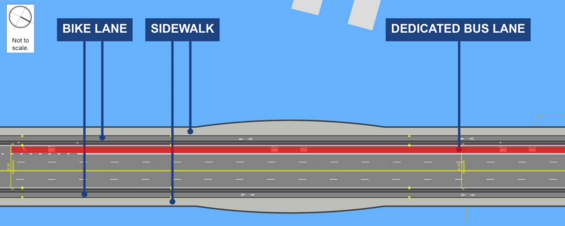
During project presentation meetings, it is helpful to provide handout materials that present the project and its alternatives, such as concept engineering plans, so that the participants have a reference to review. A visual depiction of each build alternative is beneficial. The visual representation should be prepared so that a layperson can understand the alternative being presented. Figure 2‑2 and Figure 2‑3 show examples of how a project might be presented to the public.
Figures 2-2, 2-3: Example of Visual Representation of a Project Alternative
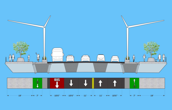
Source: MassDOT
Source: MassDOT
Final Recommendations
In this last component of the planning process, the proponent should document the process, public outreach, and decisions made in a planning report. The planning report documents:
- The need for the project
- Existing and future conditions
- Alternatives considered
- Project benefits and impacts
- Project consistency with policies and local plans
- Public outreach process
- Final recommendations
The project proponent may, at their own discretion, distribute the draft planning report to the appropriate local officials, staff, or key project constituents for review.
The project proponent may also elect to have final public review of the planning recommendations by holding an additional public meeting or by notifying past project participants of the availability of the draft planning report at an accessible municipal location for review.
Upon receipt of comments and public input (if sought on the draft report), the project proponent should finalize the planning report.
Review of Planning Efforts
Upon completing the project planning effort, the project proponent has two options based on its outcome: advance the planning recommendations, or delay or drop the planning recommendations from consideration.
If seeking to advance the planning recommendations, the MPO can provide insight into project design considerations in addition to likely steps needed for project approvals. With this approach, valuable guidance can be provided prior to the proponent investing significant time and resources in project design.
Ideally, at this stage, the project will be well-documented as well as locally reviewed and endorsed, and the proponent can proceed to Step 2: Project Initiation, as outlined in the following section.
Step 2: Project Initiation
Step two of the nine steps in the Project Development process.
Projects begin with the identification of a problem, need, or opportunity through the following avenues, including but not limited to:
- Planning processes, as described in Step 1: Planning and Needs Assessment
- Asset Management Systems
- Performance Management Systems
- Congestion Management
- Safety Management (including the Highway Safety Improvement Program, or HSIP)
- Operational Plans and Initiatives
This step entails the creation of the project in the MaPIT system. Programming, which is shown in this chapter as Step 6, may also occur at any point in the project process beginning at the conclusion of Step 2.
All MassDOT projects must be initiated through the Massachusetts Project Intake Tool (MaPIT). This is an online application designed to help proponents map, initiate, and scope roadway projects while screening against all in-house GIS (geographic information system) resources MassDOT deems relevant to project initiation. Proponents need a MassDOT-appointed login to use the tool, and, once acquired, have access to various workflows containing the appropriate Initiation Forms for each project type.
At the conclusion of the process in MaPIT, the system will produce a document called the Project Initiation Form (PIF). The PIF is the document that is produced by MaPIT at the end of the Project Initiation process, and includes the information about the project need, the project description, and estimated costs. Once a project is approved the project information is transferred to ProjectInfo, which is MassDOT’s online project tracking system.
Workflow Initiation in MaPIT – Project Need
This step in the project development process leads to completion of the Project Need (PN) step in MaPIT workflows. The PN provides sufficient material to understand the transportation need(s), and results in one of the following three outcomes:
- Verification of the problem, need, or opportunity to enable it to move forward into design
- Determination of the level of further project planning warranted
- Dismissal of a project from further consideration
At the beginning of this process, the proponent is encouraged to meet with potential participants, such as MassDOT District staff, the MPO, regional planning agencies, environmental agencies, local boards and officials, and community members. This proactive, informal review and consultation can help ensure the project will develop successfully in future phases.
The Project Need (PN) step is important to define the condition, deficiency, or situation that indicates the need for action. The proponent should provide the project need statement and support the statement with facts, statistics, or even plans or photographs to the extent that information is available.
The goal of the Project Need is to state the deficiencies or needs related to the transportation facility (such as “the bridge is structurally deficient” or “the pavement is in poor condition”). The Project Need should document the problems and explain why corrective action is needed.
In addition to clearly defining the need that the project will address, the project proponent will provide details about the current facility (if applicable) and the proposed facility at this step. This includes a planning level proposal for the number and width of travel lanes, bike lanes, sidewalks, shoulders, among other features, if known. The project proponent also provides an initial cost estimate for the project at this point.
Project Need Review
Once the PN is completed in MaPIT, it is submitted to the appropriate MassDOT District Office for initial review. MassDOT typically develops a multi-disciplinary team to review project requests. District staff must communicate with the proponent to discuss the problems, needs, and/or opportunities they have identified.
For municipality-initiated projects, a meeting with the proponent, ideally as part of a site visit, will be scheduled to discuss the project in detail.
Following the meeting and/or site visit with the proponent, District staff will determine if the project described in the PN should advance in the project initiation process. After the Project Need has been reviewed and evaluated by the MassDOT District Office, accepted projects will be approved in MaPIT and the system will allow the proponent access to the next step in MaPIT, Project Scope.
Step 3: Preliminary Project Scope and Cost
Step three of the nine steps in the Project Development process.
The third step in the project development process formally begins the review and evaluation of the project by the PRC, followed by review and evaluation by the MPO. Following the approval of the Project Need, the proponent will gain access to the Project Scope and Cost pages in MaPIT. The proponent should provide a preliminary project scope of work and estimated costs for design and construction. Separately, the proponent should submit any supplemental documentation to the District, including any project planning report, new traffic counts, or concept plans.
Project Scope
The Project Scope section of the MaPIT workflow allows project proponents to describe in more narrative detail the proposed preliminary scope of work in this project. The form also requires that the project proponent develop a project justification in the following areas:
- System Preservation
- Mobility
- Safety
- Economic Impacts
- Social Equity and Health
- Environmental Effects
- Policy Support
Answers to these questions and all other information entered into MaPIT determines the scoring of the project by the Pre-PRC Committee. (See Pre-PRC Meeting in Step 4 for more information.)
Cost
The final portion of the MaPIT workflow is a cost table that incorporates cost estimating practices commonly used by MassDOT, including contingencies, traffic police costs, and utilities estimates. This process ensures that all costs associated with a project are included in the cost estimate carried forward. The form also provides an opportunity to identify likely funding sources. Consultation with MassDOT reviewers may be necessary at this step of the process as well.
Once complete, MaPIT sends a notification to the appropriate MassDOT District Office for review. During this review period, the proponent will not be able to edit the PIF further until the review is complete.
Final Review
If the Project Scope and Cost is accepted, the District or Program Manager(s) who reviewed the forms will have access to a Final Review step, which consists of questions related exclusively to project risk. These questions encompass several risk factors related to design, construction, ROW, environmental permitting, and utilities. Once these questions are answered by the MassDOT reviewer, the PIF is complete, and the project is ready for migration to MassDOT’s ProjectInfo system. The combined PIF, produced by the MaPIT system, will serve as the definitive guidance document for MassDOT Highway Division Priority Scoring, review of the project for approval at the Project Review Committee, and at the pre-25% Project Scoping Meeting.
Step 4: Project Creation and Approval
Step four of the nine steps in the Project Development process.
After all other project intake steps completed in MaPIT, the District staff will then send the project to ProjectInfo. This step finalizes the official project name and project number. The District staff will also send the proponent the PDF printout of the PIF, generated by MaPIT, and address any outstanding items in ProjectInfo.
MaPIT uses the information entered by the project proponent to assign a draft project score based on the Highway Division’s criteria. The draft score is used by the Project Evaluation Working Group (also known as the pre-PRC) to ensure the scoring is consistent between projects. Highway Design and Environmental will conduct a cursory review of the draft project scoresheets for completeness and a preliminary review of the environmental criteria.
Pre-PRC Meeting
The Working Group (also known as the pre-PRC Committee) will meet two weeks before the PRC meeting to develop a final scope and revised scoresheets, if necessary. The Working Group is chaired by the Highway Design Engineer or appointed Working Group Chair and includes but is not limited to representatives from all six District offices, Environmental, Highway Design, Bridge, Asset Management, Program Management, Traffic Engineering, Pavement Management, Right-of-Way, Federal Aid Program Reimbursement Office (FAPRO), Office of Diversity and Civil Rights (ODCR), Federal Highway Administration (FHWA), and the Office of Transportation Planning (OTP). The final project score and revised scoresheets are then entered into ProjectInfo.
Table 2-1: Timeline for Project Review Prior to PRC Meeting
| PRC meeting timeline | Day of the week | Milestone |
|---|---|---|
| 4 weeks before the meeting | Friday | New project deadline |
| 2 weeks before the meeting | Thursday | Pre-PRC Meeting |
| 1 week before the meeting | Tuesday | Final Project Scores and Project Scoresheets uploaded to ProjectInfo |
| Week of the meeting | Thursday | PRC Meeting |
| 1 week after the meeting | Tuesday | Final PRC results sent to Deputy Chief, Bridge, Program Management, and Deputy Director of Project Management |
| 2 weeks after the meeting | Tuesday | Post-PRC Meeting - Bridge |
| 2 weeks after the meeting | Wednesday | Post-PRC Meeting - Highway |
Project Review Committee (PRC) Meeting
The PRC meets three times a year, generally late spring, late summer, and late fall, and is chaired by the Chief Engineer, who may also determine that more frequent meetings are necessary. The PRC is comprised of the Deputy Chief Engineer of Project Development, District Project Development Engineers (and their staff), Program Management, PRC Secretary, and, as needed, representatives from Asset Management, Project Management, Major Projects, Highway Design, Environmental, Right-of-Way, Bridges and Structures, Traffic Engineering, Highway Maintenance, Highway Operations, Office of Diversity and Civil Rights, Federal Aid Programming and Reimbursement Office (FAPRO), FHWA, and OTP. The PRC will review the Project Forms and take one of the following actions:
- Approve: The project moves forward into design and programming review by the MPO (see Step 6: Programming)
- Table: No action is taken on the project, and it is kept on the agenda for the next meeting
- Deny: The project is removed from consideration for design and programming review by the MPO. It should be noted that projects may be denied at this stage because the PRC determines that funding processes outside the Transportation Improvement Program are more appropriate and afford a more streamlined implementation.
For approved projects, the PRC will assign an estimated advertising date for a project with the expectation that the project will be programmed in the State Transportation Improvement Program (STIP) or Capital Investment Plan (CIP). An advertising date may be assigned outside the 5-year STIP/CIP cycle until the project is scoped and project development commences.
After the PRC action, a notification will go from the MassDOT District Office to the project proponent and other interested parties.
If the project is approved, a MassDOT Program Manager will be assigned and will request PARS (Project Accounting and Reporting System) numbers for payroll and project development costs related to the project. The MassDOT Program Manager will evaluate the need for a Project Scoping Meeting. If required, one will be held using the Project Scoping Checklist. The Project Scoping Meeting is further described in Step 5: Project Development and Design.
MPO Review and Comment
After approval by the Project Review Committee, projects to be programmed by the MPO are forwarded for review and assessment for future regional transportation resource allocations. It is expected that the MPO (and its Regional Planning Agency) will review project planning documentation and the Project Review Committee comments to start their effort. The MPO will review and assess the project in comparison to other projects under consideration in its region and determine the potential year for funding in the TIP.
Possible outcomes from the MPO review of the Project Initiation Form are:
- Project Transportation Evaluation Criteria Score
- Possible TIP Year
- Tentative Project Category
- Tentative Funding Category
The MPO will also be able to review projects that are not approved by the Project Review Committee and can provide additional comments to the proponent so that future submissions can be streamlined.
At this stage in the process, it is possible (but unlikely) that the project will get fully programmed by the MPO. For projects given favorable review, this most often happens later, either during or after the design phase. See Step 6: Programming for more information about funding for projects.
Step 5: Project Development and Design
Step five of the nine steps in the Project Development process.
Step 5 begins the project development and design process leading to construction. As illustrated in Figure 2‑4, the process starts with scoping, which informs four distinct, but tightly integrated, elements:
- Public outreach
- Environmental documentation and permitting
- Project design
- ROW confirmation/acquisition (if needed)
Public outreach activities and requirements are integrated within each technical task. This continual involvement will help to ensure the project’s ultimate success. Before initiating design, the designer should take time to review all prior planning documents and public input about the project.
Although the technical requirements for environmental, design, and ROW efforts are presented sequentially in the PDDG, these activities are conducted concurrently and in a coordinated process to ensure that the ultimate project is acceptable, constructible, permittable, and responsive to the project goals and objectives. All these activities are keyed to the design process schedule. Ideally, this work should immediately follow the planning effort to take advantage of both existing conditions research and public support/consensus about the need for action.
The outcome of Step 5 is a designed and permitted project ready for construction.
Scoping
During scoping, the project defined in the planning or needs assessment and project initiation phases is developed in more detail. While a preliminary project scope is prepared during project initiation as described in Step 3: Preliminary Project Scope and Cost, the scope typically needs to be refined before entering the design phase to ensure that it aligns with MassDOT policies and requirements.
After the PRC has approved the project, a designer is selected if one is not already assigned. Throughout the previous planning and project initiation processes, different practitioners will have gained knowledge about the context of the project, the issues raised during planning, and the desires of the community, MassDOT, and the regulatory agencies concerning project implementation. This knowledge may be distributed among the project proponent, planning staff, MassDOT District staff, MassDOT Program Management staff, MPO staff, and others. It is imperative that this knowledge is collected and shared with the designer prior to initiating the design. The scoping process is key to this knowledge transfer. If the project is being designed by a municipality or other agency (such as DCR), the proponent must hire a firm that is pre-qualified in the appropriate discipline by MassDOT Highway Division’s Architects & Engineers Review Board. Proponents should refer to MassDOT’s database of pre-qualified Architectural and Engineering Firms.
The MassDOT scoping procedure includes the following activities shown in Figure 2‑4 and described in more detail in the sections below:
- Prepare Project Scoping Checklist & Environmental Review Checklist
- Start Intersection Control Evaluation (ICE) Process Stage 1, if applicable
- Determine whether to hold Project Scoping Meeting (PSM)
- Conduct PSM, if needed
Figure 2-4: Scoping Process
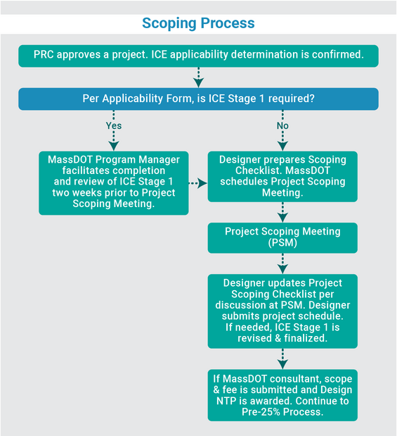
Source: MassDOT
Prepare Project Scoping Checklist
The MassDOT Highway Division has created a Project Scoping Checklist for roadway and bridge projects to ensure that the design services include all necessary work tasks for successful completion of the project’s design. The checklist provides a consistent method for stakeholders to identify risks to pursuing the scope as approved by the PRC (such as underground utilities, limited ROW, and potential environmental impacts) and to begin the process of establishing a cross section.
The designer should fill out the Project Scoping Checklist with information derived from MaPIT reports and GeoDOT.
Start Intersection Control Evaluation (ICE) Process
The purpose of an Intersection Control Evaluation (ICE) is to consider multiple control strategies in a consistent manner when planning a new intersection or modifying an existing intersection. The goal of an ICE is to objectively select a control strategy that meets the project’s purpose and need and fits the intersection’s location context and roadway classification, while achieving the overall long-term best value.
For intersections where intersection control evaluation (ICE) was deemed applicable during PRC Approval, ICE Stage 1 must be reviewed by the Traffic & Safety and District Traffic sections prior to the PSM. The MassDOT Program Manager will facilitate completion and review of ICE Stage 1 two weeks prior to the PSM, coordinating with the designer as needed. Refer to the ICE Website for details on this process.
Determine Whether to Hold Project Scoping Meeting
To ensure that the proponent, the designer, and MassDOT agree on the proposed scope of work for the project, many projects hold a PSM. The MassDOT Project Manager and Program Manager determine if the PSM is required with consultation with the Deputy Chief Engineer for Project Development. If a meeting is required, it should be held within six months of the project receiving PRC approval.
Conduct the Project Scoping Meeting
The MassDOT Program Manager will create the meeting invitation list based on the project type, including representation from the District, municipality, and relevant MassDOT review sections.
At the PSM, the designer and MassDOT Project Manager or Program Manager will conduct an overview of existing conditions, review the Purpose and Need and Scope of Work as approved by the PRC, and review the Project Scoping Checklist, updating it as needed per discussion with attendees. Any known utility constraints, preliminary environmental permitting requirements, traffic and safety analysis requirements, and potential design justifications will be discussed up front.
This discussion will guide the designer to determine what data collection and conceptual analysis is needed to achieve consensus on a preferred alternative at the end of the pre-25% design phase and the required deliverables for this design phase, as discussed in the section Project Design below. There is also an opportunity to discuss streamlining the project based on risk and complexity.
Following the PSM, the designer should develop a project design schedule. For MassDOT consultants, a scope and fee will be developed based on the outcomes of the PSM.
Public Outreach
Continued public outreach in the design and environmental process is essential to maintain public support for the project; ensure that the project continues to meet its intended purpose; and seek meaningful input from interested citizens, local and regional groups, and elected officials on the design elements. Public outreach is integrated into every step of the project development process defined in this chapter. It is particularly important to provide opportunities for public outreach early in project planning.
Identify Project Constituents
Early in the project development process, the proponent should consider the public support for the project and the constituency that it serves. Project constituents are groups and individuals that are involved in, have interest in, have influence over, or are affected by a proposed project. They can either be formal participants in the process or represented by other participants. Different types of projects involve different constituents as well as different levels of planning and review. Project constituents include some or all of the following entities:
- Federal Highway Administration (FHWA)
- MassDOT
- Metropolitan Planning Organizations
- Regional Planning Agencies
- Regional Transit Authorities
- Transportation Providers
- State and Federal Regulatory Agencies
- National Park Service
- U.S. Coast Guard
- Native American Tribes
- Other State Authorities
- Elected Officials, Public Works Departments, Local Boards, and Commissions, including Conservation Commission and Historical Commission
- Facility users (commuters, residents, visitors by all modes)
- Environmental Justice (EJ) populations
- Neighbors and citizen groups
- Municipal commission(s) on accessibility
- Regional Independent Living Center(s)
- Advocacy and interest groups (such as local pedestrian or bicycling committees, trucking associations, preservation groups, etc.)
- Private area businesses
- Local emergency responders
- Utilities (including railroads)
- Regional watershed or river management councils
At a minimum, the proponent should contact the appropriate local planning and public works staff, planning commission chair, conservation commission chair, select board chair, and major local property owners in the vicinity of the project area to help determine initial concerns and issues. The proponent should confer with municipal officials to determine which property owners may have legitimate issues that the project should address. This effort will help identify important local groups, such as neighborhood associations, business associations, historical societies, recreation and open space committees, transportation providers, and others who should be informed of the project. It is better to be as inclusive as possible early in the Project Development Process to allow the public to participate and be afforded an opportunity to contribute to the decision-making process for the project. It should also be made clear to all those attending how comments will be treated and how any expected follow-up will be handled.
Identifying the likely parties that may have interest in the project at the beginning of the project development process helps the project proponent tailor the public outreach program appropriately. The project proponent should define a public participation plan at the outset of each step of the project development process.
Public Outreach Tools
The first stage in public outreach is to make people aware of a potential project. Legal notices alone are ineffective at informing the community about upcoming project meetings. The project proponent should carefully consider the best-suited approach to public outreach, depending on the complexity of the project. Some general approaches to increase awareness of a project and solicit input are described below:
- Notification of Abutters: Project proponents for all projects, other than routine maintenance, should, at a minimum, notify abutters of the construction program anticipated and its potential impacts to property and/or operations. This can be informally done through neighborhood flyers, posters, or newspaper notices. Formal notifications, if provided 30 days in advance to abutters by registered or certified mail, give MassDOT the authority to conduct survey and field investigations without it being considered trespassing per MGL Chapter 6C, Section 3(24).
- Notification of Utilities: Project proponents should notify utilities of the construction program anticipated and its potential impacts to their services or operations. It is important to notify utilities even for routine resurfacing and rehabilitation projects to coordinate any planned utility work. This is especially true for an overlay, since pavement life is shortened considerably following a utility cut.
- Community Notification: As projects become more complex, disruptive, and of longer duration, notification should be made to the community as a whole using the public outreach tools discussed in the next section. This community notification helps increase knowledge of the project and its potential construction-related impacts. Beyond simple notification, the proponent should actively involve abutters, specific local interest groups, and utilities to get a good cross-section of people to participate.
- Early Involvement of Local Boards and Commissions: The proponent should consider involving local boards and commissions at the outset of the project. This involvement can help the proponent identify issues the project is likely to face and can help the proponent gauge the type of additional outreach activities that may be most appropriate if the project proceeds. Outreach to local boards and commissions can also be helpful for complex maintenance and resurfacing projects. It is safer to notify all municipal departments/boards of a project’s scope before much design work is started to minimize later concerns or needs for project changes.
- Early Local Issues Meeting: An early local issues meeting is important for projects where transportation facilities are being substantially modified, expanded, or replaced. It is recommended that this meeting be widely advertised, as discussed below. This meeting provides a forum for project constituents to make their concerns known before a course of action is determined. For straightforward projects, this early local meeting, coupled with later opportunities for public hearings during design and permitting, may be sufficient. For more complex projects, or for projects that cover multiple jurisdictions, several early local issues meetings may be necessary.
- Public Forums or Hearings at Several Stages of Planning and Design: As project complexity continues to increase, the public participation should include several opportunities for public involvement during the planning and design phases in addition to the early local issues meeting described above. Targeted mailings can be used to generate interest and ensure that concerned parties are contacted. Key milestones where public involvement is especially important include alternatives analysis during the planning process, at key design milestones, or if the project elements change substantially due to increasing refinement of the design. Detailed meeting minutes are recommended for each session.
- Active Communication about Project Progress: In addition to interactive public forums, active communication about project progress is helpful for maintaining consensus and keeping project constituents informed about the project’s status. One good tool is the Project Information menu on MassDOT’s website. Several additional tools for communicating project progress are highlighted in the following section.
- Formation of an Advisory Task Force for Complex Projects: An advisory task force of project constituents can be particularly helpful for maintaining involvement from a consistent group of individuals representing a cross section of interests in the project. This formalized type of public outreach is generally reserved for more complex projects with a wide range of alternatives, benefits, and potential impacts. In almost all cases, formation of an advisory task force does not replace the need for the other public outreach approaches described above. Citizen Advisory Committees may also be established by the Secretary of the Executive Office of Environmental Affairs (EOEA) as part of the Massachusetts Environmental Policy Act (MEPA) process. The charge of an advisory group should be defined at the outset with an unambiguous definition of the limits of their decision-making authority. Typically, task forces are advisory bodies that offer input to the process and suggest recommendations.
Table 2‑2 provides a public outreach matrix by project type to help the project proponent to determine the scope of this effort at the outset. Different types of projects are likely to elicit different levels of community, resource agency, and local board interest. The schedule of these meetings depends on the project’s complexity and its permitting requirements. These project types are grouped into system preservation projects and system improvement or expansion projects with guidance provided on the appropriate level of public outreach, as explained further in the following paragraphs.
Table 2-2: Typical Public Outreach Approaches for Different Types of Projects
| System Need | Project Type | Notify abutters and utilities of construction impacts* | Notify community and involve abutters | Early involvement of Local Boards/ Commissions | Early Local Issues Meeting | Public forums at several stages of Planning and Design | Active communication about project progress | Form an Advisory Task Force |
|---|---|---|---|---|---|---|---|---|
| System Preservation | Roadways, Sidewalks, Shared Use Paths - Maintenance | May be helpful | Typically not applicable | May be helpful | Typically not applicable | Typically not applicable | Typically not applicable | Typically not applicable |
| System Preservation | Roadways, Sidewalks, Shared Use Paths - Resurfacing | Suggested | May be helpful | May be helpful | Typically not applicable | Typically not applicable | Typically not applicable | Typically not applicable |
| System Preservation | Roadways, Sidewalks, Shared Use Paths - Reconstruction/ Reconfiguration within Existing Cross Section | Recommended | Recommended | Recommended | Suggested | May be helpful | May be helpful | May be helpful |
| System Preservation | Bridges - Maintenance | May be helpful | Typically not applicable | May be helpful | Typically not applicable | Typically not applicable | Typically not applicable | Typically not applicable |
| System Preservation | Bridges - Rehabilitation | Suggested | May be helpful | May be helpful | Typically not applicable | Typically not applicable | Typically not applicable | Typically not applicable |
| System Improvement or Expansion | New Roadway or Shared Use Path | Recommended | Recommended | Recommended | Recommended | Recommended | Suggested | Suggested |
| System Improvement or Expansion | Widened Roadway, Widened or Added Sidewalk, or Widened Shared Use Path | Recommended | Recommended | Recommended | Recommended | Suggested | Suggested | May be helpful |
| System Improvement or Expansion | Intersection, Roundabout, or Traffic Signal Modification | Recommended | Recommended | Recommended | Recommended | Suggested | Suggested | May be helpful |
| System Improvement or Expansion | New Interchange or Interchange Reconfiguration | Recommended | Recommended | Recommended | Recommended | Recommended | Suggested | Suggested |
| System Improvement or Expansion | Roadside Safety, Sidewalk, or Signage Improvements | Recommended | Suggested | Suggested | Suggested | Suggested | Suggested | Typically not applicable |
| System Improvement or Expansion | Traffic Calming, Streetscape, Lighting, or Transit Enhancements | Recommended | Recommended | Recommended | Recommended | Recommended | Suggested | May be helpful |
| System Improvement or Expansion | New or Widened Bridge | Recommended | Recommended | Recommended | Suggested | Suggested | Suggested | Typically not applicable |
| System Improvement or Expansion | New or Expanded TDM/Park-and-Ride Lot | Recommended | Recommended | Recommended | May be helpful | May be helpful | May be helpful | Typically not applicable |
| System Improvement or Expansion | New or Expanded Traffic Management System | Recommended | Recommended | Suggested | May be helpful | Typically not applicable | Typically not applicable | Typically not applicable |
Public Outreach Approach
The level of interest and role of the public varies by project type and complexity. Outreach is often in the form of required public hearings but can also include other opportunities for dialogue, such as public meetings, briefings, workshops, or charrettes with those interested in and affected by a proposed project.
Public hearings are legally recognized formal meetings held at select times during the project development and design phases. A public hearing is required for any project that meets one of the following conditions:
- Requires ROW acquisition
- Substantially changes the layout or functions of connecting roadways/the facility being improved
- Has a substantial adverse impact on abutting property
- Has a significant environmental, social, economic, or other effect
An additional public hearing will be provided when there have been any of the following:
- A significant change in the proposed project (or design details)
- Identification of significant environmental, social, or economic effects not considered at earlier public hearings
- Substantial unanticipated development in the project area
- An unusually long time lapse (for example, more than two years) since the last public hearing
There are many opportunities for public meetings or hearings throughout the project development process. The types of public hearings or meetings that can occur during the project development process are highlighted in Table 2‑3. The schedule of these meetings depends on the project’s complexity and permitting requirements.
Public meetings and hearings may be held virtually or in-person. All virtual meetings should follow MassDOT’s Guidelines for Successful Virtual Meetings. All in-person public meetings and hearings should be held in facilities that are fully accessible for people with disabilities, and notices about these meetings should use the International Symbol of Accessibility to indicate that the location is accessible. Handout materials available in alternative formats—Braille, large print, and/or audio cassette—as well as other accommodations such as sign language interpreters, or Communication Access Realtime Translation (CART) reporters, should be indicated in the meeting notices along with specifically how to request these accommodations.
Key public meetings during the environmental/design/ROW process are discussed below:
- Location/Design Public Hearing: This signals a decision point for major projects and is held after an environmental document is circulated but before MassDOT is committed to a specific alternative from among the reasonable and feasible alternatives under consideration, including the no-build alternative. The hearing(s) is usually held during the planning process but can also be held during preliminary engineering. This public hearing provides an opportunity for the public to provide input into the need for, as well as the location and design of, a proposed project. It also serves as a means of summarizing any previous comments and concerns relative to the alternatives under consideration and provides a formal review of the major points being addressed in the environmental document.
- Design Public Hearing: This is held for all projects subsequent to the review and acceptance of the 25% design plans by MassDOT.
- Permit or Clearance Hearings: Many of the specific environmental review requirements for projects have their own public outreach requirements. These requirements must also be satisfied to obtain the necessary environmental permits and clearances.
If a Federal Environmental Assessment (EA), Environmental Impact Statement (EIS), or state Environmental Impact Report (EIR) is required, a public hearing should be held during the period of the public review. The public can then comment on the impacts of the project as well as the project design. Some environmental or resource agency permits or clearance processes also require public hearings. See the “Environmental Documentation and Permitting” section for more information.
Environmental and design hearings are sometimes ineffective at eliciting community concerns and addressing individual issues. Additional ways to communicate with those interested in or affected by projects include:
- Public Meetings are informal gatherings of practitioners, officials, and local citizens to share and discuss proposed actions. These meetings provide an opportunity for informal, less structured conversations about a project, the design elements, and its potential benefits and impacts.
- Open Houses are mechanisms for interested parties to gather more details about a project. Open houses facilitate the discussion with individuals more effectively than traditional hearings or public meetings.
- Workshops or Charrettes are smaller groups that facilitate problem solving around design issues for which several options are available and the best solution is unclear.
- Other communication tools that effectively inform the public and solicit their input include:
- Newsletters provide a forum for meeting notification and periodic updates on project status and decisions. Newsletters can either be traditionally mailed or electronically transmitted.
- Websites allow frequent updates of the project’s status, enabling interested parties to review materials on their own schedule. Websites facilitate correspondence of questions and responses and should be designed to meet access standards for electronic media as defined in the Massachusetts Web Accessibility Standards. Direct constituents to a website by providing a QR code on a flyer or notice.
- Project Information Boards illustrate project details and provide contact information. Information boards can be posted at the project site or in civic buildings, churches, or other neighborhood buildings.
- Articles and Frequently Asked Questions (FAQ) Sheets provide project details to a wide audience. Articles can be written for local newspapers or as editorial letters.
- Notices communicate messages to local boards, committees, and local or statewide advocacy groups or press releases to media outlets
- Language Access Assistance through any of the above communication tools provides information to Limited English Proficiency populations about how to access translated materials and how to request interpreter services.
Table 2-3: Typical Public Meetings During Project Development
| Project Development Step | Public Meetings/Hearings |
|---|---|
| 1. Planning | Early Local Issues Meeting(s) Alternatives Presentation (if needed) Project Presentation (if needed) |
| 2. Project Initiation | Local Meetings (Board of Selectmen, Local Transportation Committee, Neighborhood, etc.) |
| 3. Preliminary Project Scope and Cost | None |
| 4. Project Creation and Approval | None |
| 5. Environmental: | Public Informational Meeting (if requested) Citizen Advisory Committee Meetings for EIS process (if established) Scoping Hearing for EIS (if applicable) Draft EIS Hearing (if requested) Public Hearing for Coast Guard Bridge Permit (if applicable - can be combined with 25% Design Public Hearing) Public Hearing for US Army Corps of Engineers Programmatic General Permit (PGP) (if applicable) Public Hearing for Chapter 91 Waterways Licensing (if applicable) |
| 5. Project Design | Location Public Hearing1 Special Hearing2 Design Public Hearing (25%) |
| 5. Right-of-Way | Public Hearing and/or Town Meeting |
| 6. Programming | TIP Meetings (varies by MPO) |
| 7. Procurement | None |
| 8. Construction | Community Informational Meeting(s) |
| 9. Post-Construction | Post-Construction Meeting |
Notes:
- To seek public input on a major project decision or location.
- Generally held in response to a community request or to seek additional input for decision-making.
Environmental Documentation and Permitting
Early involvement by the project proponent to understand and develop a plan of action to address the anticipated environmental consequences of the project is essential. This effort can also shape a more environmentally responsive and sustainable design. This section describes some standard procedures that help identify initial project design parameters, initiate early coordination with the community to identify issues specific to the project, and define essential information to incorporate into the 25% design and initiate early environmental reviews.
Interagency Coordination
Project delays can be minimized by early and ongoing coordination with Federal, state, and local agencies with jurisdiction by law or special expertise. Proponents should consult the MassDOT Environmental Section, or its resources, regarding this effort. If, for some reason, coordination with resource agencies did not take place in the planning process, the early steps of the design phase offer another key opportunity to perform necessary interagency coordination with resource agencies to:
- Use their technical expertise
- Reach agreement on the determination of NEPA project category
- Perform field investigations
- Discuss existing environmental deficiencies
- Determine which issues and concerns are most important
- Discuss avoidance alternatives and minimization measures
- Discuss need for wildlife accommodation (see Chapter 14 and Figure 14-1)
- Determine which appropriate mitigation measures should be evaluated
- Determine the likelihood of obtaining any necessary permits
Early coordination requirements by the project proponent are described on the following pages (some of this may already have been completed as part of project planning):
- The designer must initiate early coordination with the local environmental boards and commissions to review the project area and identify any specific issues or concerns.
- The designer should initiate early coordination with the appropriate local historical commission(s) by requesting their review and comment on the proposed scope of work and/or a locus plan showing project limits and should copy the State Historic Preservation Officer (SHPO).
- The designer should consult with the MassDOT Cultural Resources Unit for early coordination with the Tribal Historical Preservation Officer (THPO), if necessary.
- The designer must send copies of the proposed scope of work and a locus plan showing project limits to other environmental agencies to initiate early coordination.
Below summarizes a few additional important reminders for interagency coordination:
- For projects involving EISs, the appropriate time to initiate interagency coordination is during scoping. Scoping is the required process of determining the range of alternatives and impacts that will be considered in that document.
- For projects subject to MEPA, a consultation meeting with the MEPA Office of EEA helps inform interagency coordination and the MEPA process.
- For projects affecting rivers and streams, the proponent should consult with the Massachusetts Division of Fisheries and Wildlife, Division of Marine Fisheries (marine resources, especially diadromous fish), National Heritage and Endangered Species Program (BioMap), and the National Park Service (Wild and Scenic Rivers System).
- Early coordination and public information is important for projects that require filing a Coast Guard Permit. The requirement for securing a Coast Guard Bridge Permit should be identified early in the design process prior to the 25% stage. The appropriate level of information should be provided to the Coast Guard to allow them to advertise the Public Notice to Mariners. The 25% design public hearing can then be held as a joint hearing with the United States Coast Guard. The design public hearing notice should also include a statement that the project will require a Coast Guard Permit and that the design public hearing will serve as a public forum to comment on the Coast Guard Permit process.
Coordination with environmental resource agencies and boards should take place before completing the preliminary (25%) design to the greatest extent. All correspondence from the early coordination tasks should be documented, copied to key project participants (including MassDOT’s Project Manager, the District Office, and the MassDOT Environmental Section) and made part of the project’s permanent record.
Determine Massachusetts Environmental Policy Act (MEPA) and National Environmental Policy Act (NEPA) Project Category
MEPA Determination
A determination should be made, in compliance with the MEPA regulations, whether the project:
- Does not trigger MEPA jurisdiction,
- Meets or exceeds the Environmental Notification Form (ENF) review thresholds,
- Meets or exceeds the Environmental Impact Report (EIR) review thresholds, and
- Is subject to MEPA’s environmental justice (EJ) protocols, effective January 1, 2022.
The designer, in coordination with the MassDOT Environmental Section, will be responsible for determining the MEPA applicability, and obtaining or developing the necessary information to enable this determination.
Refer to MEPA Office resources for regulations, including review thresholds, and guidance regarding EJ protocols. Any project that meets or exceeds a MEPA review threshold and is within one mile (or five miles in certain situations) of an EJ census block is required to prepare and file an ENF and an EIR.
Some of the ENF review thresholds are based on the amount of wetland impact proposed. Therefore, it is critical for the designer to know the square footage or number of acres of wetland alteration at the time of the MEPA applicability determination. This information will help the designer to determine whether a variance from the Wetland Protection Act is needed or if a Superseding Order of Conditions is needed. If a variance or Superseding Order of Conditions is needed, then MEPA review is required.
If it is determined that the project meets or exceeds the MEPA review thresholds, the designer should prepare an ENF and submit it to the MassDOT Environmental Section for processing at the Executive Office of Environmental Affairs (EEA) MEPA Office. After the public review and scoping period, EEA will determine whether an EIR is required. Classification of a project in accordance with the MEPA review thresholds, and MEPA documentation, should be discussed with the MassDOT Environmental Section.
NEPA Determination
If the project involves Federal funds or other Federal action, the lead Federal agency (in most cases, FHWA) must determine whether a project’s environmental effects are likely to be significant, and as such, what level of review is required. The project determination will result in one of three levels of environmental review being selected:
- No significant effect: The project is a categorical exclusion (CE) (Class II action)
- Uncertain effect: Requires preparation of an Environmental Assessment (EA) (Class III action)
- Significant effect: Requires preparation of an Environmental Impact Statement (EIS).
An agreement should be reached with the appropriate Federal agencies on the NEPA classification. The MassDOT Environmental Section will facilitate such an agreement.
The MassDOT Environmental Section is responsible for preparing the necessary CE documentation. The scope and details about CE documentation, EAs, EISs, and the NEPA process must be coordinated with the MassDOT Environmental Section.
Determine Other Applicable Federal, State, and Local Environmental Laws and Requirements
The proponent, or their designated designer, in coordination with the MassDOT Environmental Section, will be responsible for identifying and complying with all other applicable Federal, state, and local environmental laws and requirements. As a project’s scope of work develops, the project designers should develop a list of environmental permits and considerations that will be required and/or should be evaluated as part of the project scope. Upon invitation to attend the Project Scoping Meeting (see Section Step 5: Project Development and Design, Project Design, Pre-25% Design Process), the MassDOT Environmental Section will review the project scope and location and will fill out an Environmental Review Checklist (ERC) to identify potential environmental permits, clearances, issues, and considerations. The design team should consider the ERC when creating the scope of work and should confirm required permits and ensure environmental issues are being considered as the project advances through the pre-25% and 25% design stages.
A brief description of the common Federal and State Laws and Requirements, their regulatory thresholds, and environmental clearance timelines are provided below.
Federal Laws and Requirements
- Section 4(f) of 1966 U.S. D.O.T. Act: FHWA (or other Department of Transportation agency, as applicable) approval is needed for any Federal-aid highway project using land from a publicly-owned park, recreation area, historic property, or wildlife and waterfowl refuge. A historic property may be a bridge, building, structure, site, district, or object. Either an individual or programmatic Section 4(f) evaluation document must be prepared. There must also be coordination with the public official having jurisdiction over the Section 4(f) property.
- Section 404 of 1972 Clean Water Act (33USC1344): A permit from the US Army Corps of Engineers (USACE) is required for highway projects involving discharge of dredged or fill material into waters of the United States. Jurisdiction under this law extends to all wetlands and waters of the United States. There are two types of USACE permits: Authorizations issued under the Massachusetts General Permits (MGPs) and Individual Permits.
- The MGPs include two types of authorizations: 1) Pre-Construction Notification (PCN), which entails a formal application to the USACE seeking their approval; and 2) Self Verification (SV), which entails an applicant verifying a jurisdictional activity meets certain criteria and notifying the USACE; however, the USACE does not need to issue an approval. Jurisdictional activities that do not meet the criteria of the MGPs require Individual Permit approval by the USACE. Through the PCN and Individual Permit application processes, the USACE will consult with the other Federal Resource agencies, including U.S. Environmental Protection Agency and the U.S. Fish and Wildlife Service (USFWS), prior to approval issuance. Other Federal approvals such as a water quality certification and a coastal zone consistency statement (if applicable) are needed prior to the approval issuance.
- The most current versions of the MGPs can be found on the USACE New England District website. The designer shall consult the MGPs and their associated General Conditions during early design phases to determine whether the project is eligible for PCN or SV.
- Section 401 of 1972 Clean Water Act: A water quality certification from the Massachusetts Department of Environmental Protection (DEP) is required for any Federal permit (e.g., Section 404 permit, Coast Guard Bridge Permit) to conduct an activity that may result in a discharge into waters of the United States. Additional details about the water quality certification process should be discussed with the MassDOT Environmental Section.
- 1972 Coastal Zone Management Act: A coastal zone consistency review and concurrence determination is required from the Massachusetts Coastal Zone Management (CZM) Office for Federal-aid highway projects or projects requiring other Federal actions located within the designated coastal zone. This review is to ensure consistency with the state coastal zone policies. For projects subject to MEPA review, CZM review is conducted concurrently with the MEPA process. For projects not subject to MEPA, but that require a USACE authorization, projects that meet eligibility requirements of the MGPs are considered categorically consistent with CZM policies. Other projects within the Massachusetts coastal zone are coordinated with CZM to determine if individual CZM consistency approval is required.
- Section 9 of River and Harbor Act of 1899: A permit from the US Coast Guard is required for certain highway projects involving bridges or causeways over tidal or otherwise navigable waters. Other Federal approvals, such as water quality certification and a coastal zone consistency statement (if applicable), are needed before the US Coast Guard will issue the Bridge Permit. Projects that are funded by FHWA and are "replacement in kind," such as bridge deck replacements, may be eligible for an exemption from a Coast Guard Permit. The designer should obtain data on boat length and size from the local harbormaster, as well as other knowledgeable agencies and local authorities, and consult with the MassDOT Environmental Section. Early coordination with the US Coast Guard is encouraged for all bridge projects over US Coast Guard navigable waters, through which the US Coast Guard may require a navigational impact report.
- Section 10 of River and Harbor Act of 1899: A permit from the USACE is required for highway projects requiring construction in or over navigable waters, the excavation from (or dredging or disposal of materials in) such waters, or any obstruction or alteration in a navigable water (e.g. stream channelization). Due to overlap in the jurisdiction of Section 9 (above) and Section 10, for projects requiring authorizations from both the USACE and USCG, an early coordination meeting with the agencies is encouraged to establish concurrence on what project activities will be authorized by each agency.
- Section 106 of the 1966 National Historic Preservation Act: Section 106 is a process involving FHWA, MassDOT, the Massachusetts State Historic Preservation Officer, the appropriate Tribal Historic Preservation Officer, and the Advisory Council on Historic Preservation. This process must be followed for any Federal-aid highway project affecting bridges, districts, structures, sites (including archaeological sites), or properties of religious and cultural significance identified by Federally recognized Indian tribes that are listed in, or eligible for listing in, the National Register of Historic Places. Additional details about the Section 106 process should be discussed with the MassDOT Environmental Section.
- National Pollutant Discharge Elimination System (NPDES) Construction General Permit: As authorized by the Clean Water Act, the National Pollutant Discharge Elimination System (NPDES) permit program controls water pollution by regulating point sources that discharge pollutants into waters of the United States. Point sources are discrete conveyances such as pipes or man-made ditches. The NPDES Construction General Permit is administered by the United States Environmental Protection Agency and requires preparation of a Stormwater Pollution Prevention Plan (SWPPP) for construction activities. Additional details about the NPDES process should be discussed with the MassDOT Environmental Section.
- Section 7 of the Endangered Species Act (ESA) of 1973: The ESA was enacted in 1973 to provide a program for the conservation of endangered and threatened species and their ecosystems. The USFWS and National Marine Fisheries Services (NMFS), collectively referred to as the Services, are the agencies primarily responsible for overseeing the ESA. Under Section 7(a)(1) of the ESA, Federal agencies, such as FHWA, are required, in a reiteration of Congress’ policy, to promote the conservation of endangered and threatened species. Under Section 7(a)(2) of the ESA, Federal agencies are required to ensure, in consultation with the Services, that any actions authorized, funded, or carried out are not likely to jeopardize species or destroy/adversely modify critical habitat. For projects that may affect listed species, the designer should coordinate with the MassDOT Environmental Section to discuss details and required documentation needed to support Section 7 consultation. Information on Section 7 consultation can be found on the USFWS and NMFS websites.
- Essential Fish Habitat (EFH) Assessment under the Magnuson-Stevens Fishery Conservation and Management Act: When a Federal agency authorizes, funds, or undertakes an action that may adversely affect EFH, they must consult with NMFS on that action. An adverse effect of EFH is any direct or indirect effect that reduces the quality and/or quantity of the habitat and range from large-scale ocean uses to small-scale projects along the coast. NMFS provides advice and recommendations to the Federal agency and Federal permitting agencies (e.g., USACE, USCG) to avoid, reduce, or offset these adverse effects. For projects within designated EFH, the designer should coordinate with the MassDOT Environmental Section to discuss details and required documentation needed to support EFH consultation. Information on EFH consultation can be found on the NMFS Greater Atlantic Region website.
Wild and Scenic Rivers Act (WSRA) of 1968: This Act establishes the policy that certain rivers of the Nation that, with their immediate environments, possess outstandingly remarkable scenic, recreational, geological, fish and wildlife, historic, cultural, or other similar values, shall be preserved in free-flowing condition, and that they and their immediate environments shall be protected for the benefit and enjoyment of present and future generations. The Act both identifies specific river reaches for designation as wild or scenic and provides criteria for classifying additional river reaches.
The National Wild and Scenic River System was established to protect the environmental values of free-flowing streams from degradation by impacting activities, including water resources projects. The National Park Service and designated local Wild and Scenic River Management Council review project permits to ensure that the action will not adversely affect the river system. This review function is most often through the ACOE on Section 404 permits (including section 10 of Rivers and Harbors Act) and through the US Coast Guard (Section 9 of the Rivers and Harbors Act) for navigable waterways.
- Other Federal Fish & Wildlife Acts: These acts consist of the Fish & Wildlife Coordination Act (FWCA) of 1934, the Bald and Golden Eagle Protection Act (BGEPA) of 1940, the Migratory Bird Treaty Act (MBTA) of 1918, and the Marine Mammal Protection Act (MMPA) of 1972. MassDOT projects sometimes require individual consultation with USFWS or NMFS on the FWCA, BGEPA, MBTA and/or MMPA. When applicable, the designer should coordinate with the MassDOT Environmental Section to discuss details and required documentation needed to support consultation.
State Laws and Requirements
Bridge projects funded by a State Transportation Bond, which are functionally equivalent and in a similar location, are exempt from the Wetlands Protection Act (WPA), Chapter 91, and MEPA. The project proponent should consult with the MassDOT Environmental Section for a determination.
Massachusetts Wetlands Protection Act (WPA): (MGL Chapter 131, Section 40 as administered by 310 CMR 10.00) This act applies to projects that remove, fill, dredge, or alter a resource area defined in the Wetland Regulations. Resource areas include but are not limited to:
- Bordering Vegetated Wetlands or salt marsh
- Any bank, or any water body or waterway or a coastal bank
- Land under a water body, waterway, the ocean, or a salt pond
- Riverfront area - Extends 200 feet (25 feet in municipalities with large populations and in densely developed areas) on each side of perennial rivers or streams
- Land subject to coastal storm flowage
- Isolated or bordering land subject to flooding
- Coastal beaches and tidal flats
- Coastal dunes
- Designated Port
- Banks or land under a Fish Pier
- Barrier beaches
- Land containing shellfish
Designers shall determine, in coordination with the MassDOT Environmental Section, the required level of review and permitting required under the WPA. The applicability and need for Abbreviated Notice of Resource Area Delineation (ANRAD), Request for a Determination of Applicability (RDA), Notice of Intent (NOI), and/or a WPA Variance will depend on the project scope, limit of work, anticipated impacts, and whether the project meets applicable wetlands resource area and stormwater management performance standards. ANRAD, RDA and NOI filings are submitted to the local Conservation Commission for review and approval. Appeals of Conservation Commission decisions are made to the DEP through a request for a Superseding Order of Conditions. DEP is also the authority to whom variance requests are made. Variances are required if the general performance standards of the WPA cannot be met, such as if 5,000 square feet or more of Bordering Vegetated Wetland is proposed for filling, or if the Stormwater Management Standards cannot be met for the new development portions of a project. Details regarding appeals or variances should be discussed with the MassDOT Environmental Section.
- Rivers Protection Act: The Rivers Protection Act, Chapter 258 of the Acts of 1996, protects nearly 9,000 miles of Massachusetts riverbanks. This Act helps keep water clean, preserve wildlife habitat, and control flooding. The law creates a 200-foot riverfront area that extends on both sides of rivers and streams. In certain urban areas, the riverfront area is 25 feet. The riverfront area provides the eight interests: the protection of public and private water supply, protection of groundwater supply, protection of land containing shellfish, protection of wildlife habitat, flood control, storm damage prevention, prevention of pollution, and protection of fisheries. The law also establishes the State’s policy to protect the natural integrity of rivers and encourage/establish open space along rivers. This law is administered through the WPA.
- Chapter 91, Massachusetts Public Waterfront Act: A Chapter 91 Waterways license from DEP is required for highway projects that do not qualify for the bridge exemption and that involve construction, dredging, and filling in private and Commonwealth tideland, as well as great ponds and certain rivers and streams. Additional details about the Chapter 91 process are to be discussed with the MassDOT Environmental Section.
- Chapter 254: This process involving the Massachusetts Historical Commission must be followed for highway projects affecting bridges, districts, structures, or sites (including archaeological sites) listed in the State Register of Historic Places. All properties listed in, or formally determined by the Keeper to be eligible for listing in, the National Register of Historic Places are automatically listed in the State Register. In most cases, completion of the Section 106 process for a Federal-aid highway project will satisfy the requirements of the Chapter 254 process. Additional details about the Chapter 254 process should be discussed with the MassDOT Environmental Section.
- Massachusetts Endangered Species Act (MESA): Enacted in December 1990 (MGL c.131A), this act implements regulations promulgated in 1992 and most recently revised and implemented as of January 10, 2020 (321 CMR 10.00). MESA and its implementing regulations protects rare species and their habitats by prohibiting the "Take" of any plant or animal species listed as Endangered, Threatened, or Special Concern. The Act also establishes procedures for the listing and protection of rare plants and animals, outlines project review filing requirements for projects or activities that are located within a Priority Habitat of Rare Species, establishes clear review timelines and processes for agency actions. Projects and activities within Priority Habitats of Rare Species and Estimated Habitats of Rare Wildlife must file with the NHESP for review and approval. When applicable, the proponent should coordinate with MassDOT Environmental to discuss details and required documentation needed to support a MESA filing. Please note that under this Act, if a project is located within Estimated Habitat and a NOI is required, a copy of that NOI must be sent to the NHESP (no later than the date for filing of the NOI with the Conservation Commission) for review. For additional guidance, refer to:
- Chapter 253: Proposals to construct, repair, materially alter, breach, or remove a dam, pursuant to MGL Chapter 253, as amended by Chapter 330 of the Acts of 2002, require filing with the Department of Conservation & Recreation (DCR) Commissioner a notice for jurisdictional determination and/or file for a permit (if applicable). Early coordination with DCR is encouraged for projects conducting work on or near any dams. The DCR conducts an engineering-level review, and, therefore, project design engineers bear the responsibility for this permitting process, not the Environmental Section. However, Environmental can help facilitate the coordination process with DCR. For additional guidance, refer to DCR’s Dam Safety Permit Process.
- Massachusetts Watershed Protection Act (WsPA): The WsPA regulates land use and activities within critical areas of the Quabbin Reservoir, Ware River, and Wachusett Reservoir watersheds in order to protect the quality of these drinking water sources. The WsPA is administered by the Division of Water Supply Protection (DWSP) of the DCR. The WsPA review process can occur through several means, including obtaining an Advisory Ruling by sending a letter describing the activity to DCR, applying for Determination of Applicability, applying for a Variance, and/or applying for Exemption of a Tributary. Additional details about the WsPA process are to be discussed with the MassDOT Environmental Section. DCR offers additional guidance on the WsPA.
Process Environmental Documents
The project proponent is responsible for the environmental documentation needed for the MEPA and NEPA processes and other required permits and clearances. Preparing and processing this environmental documentation should occur concurrent with the development of the 25% design plans.
For the MEPA process, the environmental documentation may include (1) an Environmental Notification Form (ENF) or an Expanded Environmental Notification Form (EENF) and (2) a Rollover Environmental Impact Report (Rollover EIR) or Single Environmental Impact Report (SEIR) or (3) a Draft Environmental Impact Report (DEIR) and a Final Environmental Impact Report (FEIR). Of relevance to MassDOT projects are new MEPA regulations promulgated in January 2023 that require a mandatory Environmental Impact Report when MEPA review is required within 1 mile of an EJ population or within 5 miles of an EJ population if the project will impact air quality. Additional information on the EJ requirements, including guidance on conducting an EJ analysis and outreach, can be found on MEPA’s Website. It is important to review MEPA’s website for the latest regulatory updates and guidance.
For the NEPA Process, the environmental documentation may be (1) documentation for a categorical exclusion (CE), (2) an Environmental Assessment (EA), or (3) a Draft Environmental Impact Statement (Draft EIS) and a Final Environmental Impact Statement (Final EIS). A determination of the environmental documentation required is described above.
All environmental review, permit submissions, and coordination with the agencies will be made through the MassDOT Environmental Section. Copies of all applications, submissions, and permits will also be sent to the District Environmental Engineer.
For additional guidance, refer to the MEPA Office and FHWA’s NEPA Environmental Review Toolkit.
Environmental Requirements for the Preliminary (25%) Design Submission
This section provides details concerning environmental elements of the project to be included with the 25% design submission to help identify project impacts and expedite environmental clearances. Including these data early in the process is intended to help identify project impacts and expedite environmental clearances. At pre-25%, the designer should cite environmental considerations identified within the Scoping Phase ERC review and provide any information about how those considerations will be addressed. The MassDOT Environmental Section will review the pre-25% submittal to confirm permitting requirements and ensure environmental considerations identified at Scoping are being addressed.
The designer should also consult the MassDOT Environmental Services website for additional useful information. Copies of all correspondence during information gathering should be made part of the project’s permanent record.
The following items should be included in the 25% plans:
Cultural Resources
- Show all bridges and culverts within or adjacent to the project limits and label all those having MassDOT bridge numbers.
- Provide photographs of all known historically significant buildings/structures within or adjacent to the project limits. Show their location and label all those having numbered street addresses.
- Show the location of historic district boundaries.
- Label all historical/locally significant monuments and markers, and, if possible, show their future location if they are proposed to be moved.
- Show a detail of the proposed type of street lighting.
- Label and show preliminary tops and bottoms of slopes and limits of all proposed takings and easements.
- Label all preliminary wall locations.
- Identify potential landscaping enhancement opportunities.
- Show all proposed trees to be removed that have a diameter at breast height (DBH) of 14 inches or greater.
- Provide copies of all correspondence with the local historic commission.
Hazardous Materials
- Identify locations of known sources of hazardous waste and hazardous material releases within the project limits (with appropriate tracking numbers).
Wetland and Water Resources
- Show the location of all existing drainage structures and existing and proposed drainage discharge locations.
- Show the location of all wetland resource areas within 100 feet of the project limits (e.g., bordering and isolated vegetated wetland areas and land under water), including the ordinary high water (i.e., one-year flood) of waterways and water bodies.
- Show the location of potential wetland replacement areas.
- Show the location of potential stormwater treatment areas.
- Show on a separate locus any storm water “critical areas” as defined in the DEP Stormwater Standards (cold water fisheries, Zone IIs, public swimming beaches, shellfish growing areas, and drinking water reservoir watershed).
- Show on a separate locus any Federal Emergency Management Administration (FEMA) floodplain and/or designated Floodways.
- Provide representative bankfull width measurements of any streams where culvert or bridge replacements are proposed.
- Show on a separate locus any Estimated Habitat for Wildlife or Area of Critical Environmental Concern (ACEC).
- Provide photographs in digital format of all bridge replacement/rehabilitation projects that include work in water or wetlands. Photographs should clearly show riverbanks of all four quadrants of the bridge and include any proposed wetland replication or flood compensation storage areas. All submissions for roadway reconstruction projects should include photos of all cross culverts where work is proposed.
- If a water body can be used for boating/canoeing, consider maintaining or increasing the clearance under bridges. Any related information should be clearly identified on the plans.
Section 4(f) Properties
- Show and label the location of all publicly owned parks, recreational areas, wildlife, and waterfowl refuges and historic properties/sites.
The following references, databases, and information sources may be helpful to the designer during the preparation of 25% plans:
Project History
- Local Planning/Public Works/Economic Development Departments (Location/Feasibility Studies)
- Regional Planning Agency (Corridor Planning Studies)
- Major Environmental Documents (EA, EIR/EIS, 4(f) Documentation)
- Design Reports
- Bridge Type Studies
Hazardous Materials Site Screening
- MassGIS for mapping and a database of certain hazardous material sites
- Federal: Comprehensive Environmental Recovery Compensation Liability Act (CERCLA) List (Federal Superfund Site List). For federal regulations, see Title 40, Code of Federal Regulations (40 CFR)
- State: Department of Environmental Protection (DEP) Bureau of Waste Site Clean-up (21E) - also known as the Massachusetts Oil and Hazardous Materials Release Prevention and Response Act (MA Superfund). For hazardous waste regulations, see 310 CMR 30.00
- Local: Fire Department/Fire Prevention Office, Board of Health, for known underground tanks and/or spills
Cultural Resources (Section 106) of the National Historic Preservation Act
- MassDOT Cultural Resources
- Local Historical Commissions
- State/National Register of Historic Places (available on MassGIS)
- The Inventory of Historical and Archaeological Assets of the Commonwealth (available on the Massachusetts Cultural Resource Information System
- Corridor Planning Studies
- MassGIS contains mapping and a database of certain cultural resources
- Tribal Historic Preservation Officer (consult with MassDOT Cultural Resource Unit)
Wetlands and Water Resources
Endangered Species, Fisheries & Wildlife Resources
- MA Division of Fisheries & Wildlife’s Natural Heritage & Endangered Species Program (NHESP)
- MA NHESP Natural Heritage Atlas
- MA NHESP BioMap
- MA Division of Marine Fisheries diadromous fish datalayer
- USFWS Information for Planning and Conservation (IPaC)
- NMFS Section 7 Mapper
- NMFS EFH Mapper
National Environmental Policy Act (NEPA) and Massachusetts Environmental Policy Act (MEPA)
Section 4(f) Properties (49 USC Section 303) Publicly Owned Parks, Recreational Areas, Waterfowl Refuges, Historic Sites
- Department of Conservation and Recreation (DCR)
- Local planning department, parks department, public works department, historical commission
- MA Division of Fisheries & Wildlife
- Division of Conservation Services at EOEEA
- MassGIS contains mapping and a database of certain publicly owned properties.
25% Submission Environmental Review
The MassDOT Environmental Section will evaluate the data collected during the 25% design process and the plans submitted. They will determine whether the project can be designed to desired design criteria or if design changes or mitigation plans will be required to resolve environmental issues and community concerns. As part of the 25% design submittal, the designer shall fill out the Consultant column of the ERC, confirming, based on the 25% design, permitting requirements and addressing the environmental considerations identified during scoping and pre-25%.
If the 25% design package is a resubmission for a project that has already been reviewed, the designer will also distribute to the MassDOT Environmental Section a summary of any proposed design changes to any previous submissions for the project.
Review Project Changes for MEPA Purposes
After the initial MEPA project category determination and MEPA processing, the designer, in coordination with the MassDOT Environmental Section, will be responsible for periodically reviewing changes to the highway project during the design phase to determine whether future MEPA review is needed. If there have been changes to the original project and the project was exempt from the MEPA regulations, then the designer must determine whether the changed project is still exempt. If so, then no further MEPA review is necessary at that time. If the changes are such that the project now meets or exceeds the review thresholds, then further MEPA review is necessary. The designer should discuss with the MassDOT Environmental Section and take the appropriate action.
If the original project met or exceeded the MEPA review thresholds and the project has changed, then the designer may need to prepare a Notice of Project Change (NPC) and submit it to the MassDOT Environmental Section for processing. Additional details about the NPC are to be discussed with the MassDOT Environmental Section. Based on information in the NPC, EEA will determine whether the change in the project or change in the ambient environment significantly increases the environmental consequences of the project and warrants resubmission of an ENF, re-scoping, supplementary documentation, or a further EIR.
For example, there are cases where a project involving wetlands originally did not meet or exceed the MEPA review thresholds for highway projects and wetland permits but now requires further MEPA review because the wetland permit threshold is exceeded. This can happen when (1) the information about wetlands at the time of the determination of MEPA project category was unknown or incorrect or (2) when the project changes and the wetland impacts change.
Also, even if no changes are made to a project that requires an EIR, further MEPA review may be necessary. If more than three years have elapsed between the filing of a Final ENF and the filing of a Final EIR, or if more than five years have elapsed between the filing of a Final EIR and a substantial commencement of the project, the designer, through the MassDOT Environmental Section, must notify EEA. EEA will consult with MassDOT, agencies, and persons who previously participated in project review and will determine whether the lapse in time or change in the ambient environment significantly increases the environmental consequences of the project and warrants resubmission of an ENF, re-scoping, supplementary documentation, or further EIR.
The MEPA process can be time-consuming and result in design changes to the project. It is, therefore, critical that the designer perform this periodic review often, whenever a project change is contemplated. At a minimum, the designer should perform this review at the 25%, 75%, and 100% design phases.
Review Project Changes for NEPA Purposes
After approval of the categorical exclusion determination, FONSI, or Final EIS, the designer, in consultation with the MassDOT Environmental Section and FHWA, will be responsible for periodically reviewing the highway project during the design phase to determine whether the approved environmental document or categorical exclusion determination remains valid. The periodic review should be documented when determined necessary by FHWA. This review should occur at the same time as the review of project changes for MEPA purposes and also prior to requesting any major project approvals from FHWA (i.e., authority to undertake final design; authority to acquire a significant portion of the right-of-way; or approval of plans, specifications, and estimates).
Continued Interagency Coordination
Continual interagency coordination is imperative throughout the design phase to address issues that may affect the processing of permit applications. These issues can be discussed and resolved before they cause a critical disagreement or time delays on a specific project. Follow-up contact with resource agencies will determine whether additional information on the project is needed.
This coordination may also alleviate the need to reopen an environmental issue at the time the permit is applied for, which may be well after this issue was presumed to have been resolved in an environmental document. If interagency coordination is performed properly, there should be no surprises during the permitting process.
Define and Initiate Permit Process
Environmental clearances and permits should be secured as early in the design process as is practicable. When used in the PDDG, the term "Permit Process" refers to any process or regulatory program that involves obtaining a permit or some other type of clearance from a Federal, state, or local agency. The following are examples:
- Section 4(f) Approval
- Section 404 Permit
- Section 401 Water Quality Certification
- Coast Guard Bridge Permit
- Section 10 Permit
- Section 106 Clearance
- Section 7 Endangered Species Act Concurrence
- EFH Assessment Concurrence
- Coastal Zone Management Concurrence Determination
- Wetlands Order of Conditions/Resource Area Delineation/Negative Determination/Variance
- MA Endangered Species Act Concurrence or Permit
- Chapter 91 License or Permit
- NPDES Permit
- MEPA Certification
- NEPA Approval
Identifying applicable permits is completed prior to the 25% design submission. Initial coordination and data gathering continues throughout the design process. Formal submission of applications to regulatory agencies should be done as soon as the required information is available but no later than the 75% design submission. The project proponent is responsible for obtaining all required permits.
Each permit process is unique and involves interagency coordination, information submission, possibly special public hearings, and specific forms or applications. Refer to Environmental Clearance Timelines for additional details of the permit process. It is critical that the US Coast Guard Bridge Permit process start during the development of the 25% design. When a Bridge Permit is required, the US Coast Guard must publish the Public Notice to mariners and requires the critical elements be provided. It is most useful if the US Coast Guard Permit hearing is held concurrent with the 25% design hearing, as discussed previously.
Complete Permit Processes
During the period from 25% to 75% design, the designer will complete and submit all necessary forms or applications to the appropriate agencies for the required permits. The 75% Design Submittal Checklist stipulates that all permit applications shall be submitted to MassDOT with the 75% submission at the latest. To expedite the permitting process, draft application submittal prior to 75% is encouraged. Permit applications (including subsequent copies of all completed correspondence, etc.) and permits will be copied to the appropriate District Environmental Engineer.
Project Design
The Project Design Process generally includes four major phases of design and five milestones:
- Preliminary design
- Final design
- Plans, specifications, and estimate (PS&E)
Pre-25% Design Process
Pre-25% design is the first step of preliminary design. The purpose of pre-25% design is to perform data collection, develop conceptual designs, identify risks, confirm the scope and cross section of the project, gain consensus on a preferred alternative, and lay the groundwork for the 25% design process. Pre-25% design typically culminates in a pre-25% Over-the-Shoulder (OTS) Review meeting as described below.
Collect Data and Prepare Conceptual Design
The designer prepares for the pre-25% OTS Review meeting by collecting any required data (such as a field survey and base plan, utility survey, crash data, Road Safety Audits, hydraulic analysis, borings, preliminary structures report, pavement test pits and cores, etc.).
The designer should consider public outreach meetings with local officials, the general public, and project abutters. Required deliverables to be prepared by the designer are identified at the scoping meeting in the last sections of the Project Scoping Checklist.
Figure 2-5: Pre-25% Design Process
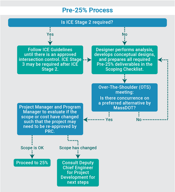
Source: MassDOT
Continue Intersection Control Evaluation (ICE) Process
If ICE was deemed applicable for intersection(s) during project initiation, it is expected that the designer will have completed ICE Stage 1 prior to the PSM. If ICE Stage 1 did not result in a single viable control strategy, then the designer must complete ICE Stage 2, and if needed, ICE Stage 3 prior to the Pre-25% OTS Review meeting. See Figure 2‑5 and the ICE Website for details on this process.
Conduct Road Safety Audit
A Road Safety Audit is a formal safety review of an existing or planned roadway or intersection that is performed by a multidisciplinary team of stakeholders. The goal of a Road Safety Audit is to determine what elements of a roadway present safety concerns and formally identify opportunities to address those concerns with low-, medium-, and high-cost countermeasures for short-, medium-, and long-term timelines. Road Safety Audits are an integral part of designing safer new roadway facilities and enhancing locations where safety concerns exist or have the potential to arise. Road safety audits foster safer road projects by promoting elimination or mitigation of safety hazards (such as dangerous intersection layouts) and encouraging the incorporation of crash-reducing features (such as traffic control devices, delineation, etc.) during the planning and design stages of project development.
During the pre-25% phase, a Road Safety Audit can be conducted for the location to identify existing safety issues and opportunities for safety improvements. A Road Safety Audit is required for certain projects, including those involving Top 5% High Crash Intersections and Segments or those planning to use federal funding through the Highway Safety Improvement Program (HSIP). Refer to MassDOT’s Road Safety Audit Guidelines for more information. The need for a Road Safety Audit is discussed at the PSM.
Prepare Draft Design Justification Workbook
The Design Justification Workbook (DJW) provides designers with a standardized method of identifying and documenting the desirable, minimum, and proposed design criteria for each controlling design element. As part of the pre-25% design process and contingent on the PSM, the designer may be required to submit a draft DJW. The purpose of submitting a draft DJW is to build consensus on the design prior to progressing to 25% design, especially in the case that certain justifications are required to be approved. The PSM is the opportunity to discuss whether a draft DJW is needed for the Pre-25% OTS Review meeting.
The process for completing the Design Justification Workbook is detailed in Section 2.4 Controlling Criteria and the Design Justification Process.
Conduct Pre-25% Over-the-Shoulder Review Meeting
The Pre-25% OTS Review meeting is held to confirm the scope and cross section of the project. Deliverables identified during the scoping meeting should be included with the meeting invitation and provided to attendees at least two weeks in advance. The project manager or program manager sets up this meeting and determines which sections of MassDOT need to participate. In-person meetings are preferred on-site or in a District office.
The project manager, program manager and designer conduct the OTS review of the Purpose and Need as approved by the PRC and reviews the conceptual design and analysis with the project team. The meeting will confirm the scope, select the preferred conceptual design, and resolve any remaining internal comments or public concerns. Any public outreach required as an outcome of the OTS review should be scheduled within three months.
The OTS review is also used as a touchpoint for MassDOT to re-evaluate whether the project in its currently designed state meets the objectives of the Purpose and Need and the scope of work as approved by the PRC. Major changes at this stage may warrant the project being resubmitted to PRC for further evaluation. The project manager will evaluate the scope of work and any public feedback against the PRC-approved Purpose and Need and scope of work. If there has been a considerable change to the scope of work outside the original PRC-approved scope or the cost estimate has increased more than 10% from the original estimate, the MassDOT project manager elevates the issue to the Office of the Chief Engineer through Project Controls for resolution.
After the re-evaluation, the Project Manager or Program Manager will update the Purpose and Need (if needed), document the scope, confirm the project description, amend the initial design scope (if needed), and notify the designer that work may formally begin on the 25% design submission. A flowchart of the pre-25% process, from after scoping to pre-25% OTS review outcomes, is included as Figure 2‑5.
Preliminary Design Process (25%)
The next step in the design process is referred to as preliminary design and results in the submission of 25% design plans. The following activities are necessary to develop the preliminary (25%) project design. Note that bridge projects must follow the Bridge Design Manual throughout the design process.
Order Necessary Survey Data
If existing survey data is not adequate to design the project, the project proponent must obtain additional survey data. This data may be in the form of either a sufficiently detailed aerial or ground survey. If the project proponent is MassDOT, the request is made to the Survey Section, providing as much specific project location data as possible. All survey work, whether completed by the designer or MassDOT, must be in accordance with the MassDOT Survey Manual.
Prepare Base Plans
This activity includes checking field notes, establishing coordinates, determining the scale used in plotting, and plotting the survey on base plans, base profiles, and base (original ground) cross sections. Work involved in plotting includes computing and adjusting the baseline, traverses, and levels. Details on base plan preparation are included in Chapter 18, the MassDOT Survey Manual and MassDOT Highway Division CAD Standards.
Develop Horizontal and Vertical Geometrics
The designer must develop the basic roadway horizontal and vertical geometry. All geometric data must be calculated at this stage (stations, bearings, distances, horizontal and vertical curve data, etc.). The design criteria are discussed in Chapter 4.
Develop Typical Cross Sections
Typical cross sections are developed based on design requirements. Typical cross sections show design elements that will characterize the project. For additional detail, the designer should refer to Chapter 5. Particular attention should be paid to multimodal accommodations in the definition of these cross sections and work completed during the planning phase to address user needs.
The designer should also seek to minimize impacts to utilities to the extent feasible without compromising user accommodation, as utility impacts can significantly contribute to project costs and delays.
Coordinate with Bridge Design
The structural designer (if applicable) should be engaged early in the development of typical cross sections and horizontal and vertical alignments to integrate roadway and structural elements of the project. Based on guidelines provided in the MassDOT Bridge Manual, bridge type studies must be developed for bridges, culverts and/or walls that are not included in the MassDOT Construction Details. The Type Studies are a preliminary presentation of the overall concept of the proposed structure to the bridge sketch plans, which are required at the 25% design stage.
Coordinate with Landscape Design
The landscape designer (if applicable) should be engaged early in the development of typical cross sections and horizontal and vertical alignments to integrate resource protection, rehabilitation, and enhancement into the design through landscaping and bioengineering. Additional guidance on landscape design is provided in Chapter 13.
Develop Draft Traffic Signal Plan (if required)
A Draft Traffic Signal Plan is developed based on guidelines provided in the most current version of the Manual on Uniform Traffic Control Devices (MUTCD). This plan shows the proposed placement of traffic control devices and is based on traffic counts, turning movements, warrants, and capacity analyses. This is in accordance with MassDOT’s Traffic and Safety Engineering 25% Design Submission Guidelines.
Develop Sketch Plans for Bridges, Culverts, and Walls (if required)
The Bridge Sketch Plans are a preliminary presentation of the overall concept of the proposed structure or proposed rehabilitation. It allows the Designer and MassDOT to agree on the principal components of the structure type or the rehabilitation scheme to be pursued in the final design phase since the Sketch Plans show all major features to be incorporated into the Construction Drawings (see the MassDOT Bridge Manual for more information).
The project proponent should also be familiar with the guidelines for Wildlife Accommodation (Chapter 14), if applicable, and the regulatory requirements of the Army Corps of Engineers and US Coast Guard for locations over wetlands and waterways as these may impact the required bridge minimum span.
Develop Preliminary Pavement Design
The designer should conduct the pavement design analysis. All pavement designs will be reviewed and approved by the MassDOT Pavement Design Engineer. The design must conform to approved MassDOT methods and must include the documentation of all background data, as detailed in Chapter 9.
Develop Preliminary Drainage Design
To develop the drainage design, the designer should first identify the regulatory stormwater requirements and use the MassDOT Water Quality Data Form (WQDF) to identify the location of impaired water bodies and requirements for stormwater treatment. Receiving waters that are impaired have requirements to meet (e.g., Total Maximum Daily Loads (TMDLs)) and the WQDF provides guidance based on watersheds that the project is located within. Using the WQDF guidance, the designer should select stormwater control measures and incorporate them into the preliminary roadway drainage design to function together. The designer should use Chapter 8 and the MassDOT Stormwater Design Guide to develop the preliminary drainage design. If test pits and/or soil borings are needed to design the stormwater control measures, the MassDOT Environmental Section prefers them to be completed during the preliminary design phase.
Develop Preliminary Utility Design
The designer shall design alterations of utilities that are located within the public ROW, which may be required due to construction of the project. Insofar as practical, and as approved by MassDOT, designs of such alterations of utilities by the designer shall conform to the requirements and design standards of the particular public agency involved. These should be submitted in the design plans in accordance with the most recent utility directives and submission policies.
Develop Preliminary Right-of-Way (ROW) Plans
See ROW Section below.
Develop Preliminary Cost Estimate
The proponent should prepare a preliminary cost estimate based on the latest project information. It is important that this estimate be as complete as possible based on quantity estimates and current unit prices with contingencies. Refinements are to be expected as the design develops, but this estimate should reflect project costs as accurately as they can be defined at the 25% design stage.
This cost estimate should itemize the participating (costs to be covered by the anticipated Federal and state funding sources) and non-participating (costs to be covered by the proponent) items. The determination of what work elements are eligible for funding should relate back to the project need definition. For example, a project to install a new traffic signal to address a high-crash location would likely not cover costs to install new street trees unless they replace trees that are impacted by the signal installation. Conversely, if the project’s intent is to restore a blighted downtown area, streetscape, ornamental lighting, pedestrian amenities would likely be appropriately included in the participating items.
For transportation improvement projects that impact existing landscape or utilities, work to restore these items is generally eligible for state or Federal funding. Typical landscape restoration activities are discussed in Chapter 13. Utility costs generally include replacement-in-kind.
Example non-participating items include:
- Improvements to municipal sewer and water systems
- Relocation of overhead utilities to underground
- Streetscape amenities (unless related to the project need)
Occasionally, project proponents may seek to use enhanced materials or treatments on projects that are outside MassDOT’s standard practices, such as incorporating public art or aesthetic pavers. The difference in cost between the enhanced material and a standard version is often calculated and considered as a non-participating cost in these situations. Consideration should always be given to how, and by whom, non-standardized items are to be maintained. Early consultation with MassDOT for project-specific guidance on what elements are likely to be participating or non-participating is beneficial. The project proponent should also be aware of unique requirements or restrictions dictated by the anticipated funding category. Information on alternative funding sources that may be available to offset the costs of the non-participating items can be obtained from MassDOT’s Office of Transportation Planning.
For further guidance, refer to Chapter 18 and the MassDOT Guide to Estimating Highway Projects.
Prepare Functional Design Report
A Functional Design Report (FDR) is a necessary component of all transportation and safety improvement projects submitted to MassDOT for 25% review, including mitigation projects developed through the Massachusetts Environmental Protection Agency (MEPA) process. Roadway resurfacing and maintenance projects are generally exempt from this requirement. Refer to the Traffic and Safety Engineering 25% Design Submission Guidelines for more information on the FDR.
Prepare Final Design Justification Workbook
A finalized Design Justification Workbook is a necessary component of the submission for MassDOT’s 25% review. The process for completing the Design Justification Workbook is detailed in Controlling Criteria and the Design Justification Process.
Submit 25% Project Package
The designer must assemble the preliminary design plans and supporting documentation as discussed above and submit the package to MassDOT for review. Refer to MassDOT’s checklist of 25% design submission requirements contained within the PDDG Checklist and Submission Distribution Workbook and the MassDOT Bluebeam User Guide.
Review 25% Project Package
FHWA, municipalities, and MassDOT design personnel, as necessary, review the 25% package. The review is conducted to ensure that the project is advancing properly and identify potential problems. Comments resulting from the review must be addressed prior to proceeding with the Design Public Hearing.
Respond to 25% Comments and Comment Resolution Meeting (CRM)
The designer shall provide responses in Bluebeam to all comments received during the 25% review period and facilitate a CRM.
Subsurface Utility Exploration (SUE) & Utility Coordination
In accordance with Engineering Directive E-21-005, the District Utility and Constructability Engineer (DUCE) will determine whether SUE Level B is required and outline locations based upon their initial review of the project. Preferably, all required SUE Level B work will be performed at the pre-25% or 25% design stage. The DUCE will coordinate a site utility coordination meeting with the impacted utility companies. Between the 25% and 75% design submissions the designer shall:
- Attempt to resolve potential conflicts through design changes.
- If conflicts or uncertainty remain, the designer shall coordinate QL-A locations with the DUCE.
- Use SUE QL-A data to further refine design to resolve conflicts.
- If conflict is unavoidable, show relocation of facility.
Conduct 25% Design Hearing (DPH)
A Design Public Hearing is held after MassDOT reviews and accepts the 25% design plans by MassDOT. Scheduling the hearing indicates the acceptance of these plans. The designer shall coordinate with the MassDOT Project Manager to determine whether the DPH will be in-person or virtual. All hearing documents must be fully accessible and meet all ADA and WCAG requirements for being posted on mass.gov.
Initiate Final Design (75%)
Once the preliminary design has been reviewed and approved by MassDOT, the designer proceeds into the final design process, as outlined below.
Prepare Subsurface Exploratory Plan (if required)
After the alignment, profile, location, and structure types have been defined and approved (25% approval), a subsurface exploratory program is developed for the required design. Subsurface explorations are required for the design and construction of structures including boardwalks, retaining walls, mast arms, noise barriers, but also for any significant cuts or fills or widening of embankments. (Refer to Bridge Manual for subsurface exploratory plan requirements for bridge projects.) Plans for the program are submitted to the project manager for review and approval by the Geotechnical Section prior to implementation by the designer. Information required to review a subsurface exploratory program includes:
- A project locus
- A narrative explaining the intent
- Boring, probe, test pit or other exploration locations plotted on plans, including a schedule showing northing, easting, ground surface elevation station, offset, highest bottom elevation, and a column for remarks and boring notes.
- The locations of the proposed structures that require exploration should also be plotted, including the footing outlines.
- If explorations are on private property, the District Offices will be furnished with a list of all property owners with their mailing addresses so they can be notified.
- A list of all the utilities within the project limits (as well as the name, address, and telephone number of the appropriate utility or public official to contact).
For additional details, refer to the MassDOT Bridge Manual – Part I, Chapter 1: Bridge Site Exploration.
Develop Construction Cross Sections
The proposed roadway cross sections (based on the horizontal and vertical geometry) and the typical section, are developed on the base (original ground) cross sections at 50-foot intervals. These cross sections are included as part of the contract documents. Refer to Chapter 18 for details.
Develop Construction Plans, Grading and Tie Plans, Drainage & Water Supply Plans
The horizontal and vertical geometry (including the location lines) developed in the preceding activities are refined. The plans should include all drawings and data necessary for construction of the proposed project, including the following proposed details:
- Road surface
- Roadway width
- Centerline
- Drives and walks
- Traffic control devices
- Edging, curbing, and berms
- Drainage appurtenances
- Stormwater control measures (also known as BMPs)
- Ditches
- Pedestrian Curb ramps
- Pedestrian access/accessible route for people with disabilities
- Bicycle accommodations
- Landscaping
- Sub-drains
- Water supply
- Roadside barriers
- Demolitions
- Bridges
- Slopes
- Fences
- Wetland resource areas or buffers
Chapter 18 provides details on various plan requirements.
Develop Temporary Traffic Control Plan (TTCP) Through Construction Zones
A Temporary Traffic Control Plan is required for any project that disrupts existing travel patterns during construction (this includes pedestrians, people with disabilities, bicyclists, and motor vehicles). If a project is on a local road or uses a local road for a detour, the municipality must review and approve the TTCP. The MassDOT Traffic Section in Boston and in the District office reviews and approves TTCPs as appropriate. Chapter 17 discusses traffic control through construction zones.
Develop Traffic-related Data
For projects involving lighting, traffic signals, signs, pavement markings, and traffic controls for construction operations, plans, special provisions, and estimates are submitted to the Traffic Section in Boston and in the District for review and approval.
Develop Drainage Design
The designer is responsible for developing a comprehensive drainage plan that will adequately drain the roadway and meet stormwater treatment requirements. In addition, the drainage plan must also protect the adjacent landowners, wetlands, and public water supplies from drainage-related problems. The designer determines the sizes, types, locations, and construction details for each drainage appurtenance and stormwater control measures (also known as Best Management Practices (BMPs)) based on hydraulic calculations and environmental considerations. When a bridge or major culvert is involved, the MassDOT Hydraulics Section, Bridge Section, and Environmental Section should be consulted. Refer to Chapter 8 and the MassDOT Stormwater Design Guide to develop the drainage design.
Coordinate Utility Relocations
Although the Utilities Engineer provides direct MassDOT contact with the utilities, the designer may be involved in the process to ensure that the relocations are appropriate. The designer's level of effort for this activity varies with the project, the utility involved, and the type of relocation. In addition, the designer may also be involved in coordinating Force Account and Betterment Agreements.
Develop Special Provisions
The designer should develop special provisions for the project if needed. Special provisions are used to explain conditions or special construction practices not covered in the current edition of the Massachusetts Standard Specifications for Highways and Bridges or Supplemental Specifications to the Standard Specifications for Highways and Bridges. In the preparation of special provisions, refer to Standard Nomenclature and Designation of Items. A draft copy of the special provisions must be provided at the 75% submission.
Special provisions include but are not limited to:
- Scope of Work (including locus map, project limits, and project length)
- Provisions for Travel and Prosecution of Work
- Work schedule
- List of Utility owners (with name and address, of contact person)
- List of Items which have material options
- Individual contract items not covered in Standard Specifications, or if deviations to the Standard Specifications are made. The MassDOT Standard Nomenclature booklet identifies those items specifically requiring a Special Provision
- Special Precautions (other facilities such as structural foundations, ponds, streams, etc.)
- Special permission or construction methods stipulated in the environmental permits
- Copies of Permits, Licenses, Certificates, or Orders of Conditions (when available)
- Scheduling requirements (milestones, completion dates)
The Specifications Section will provide standard inserts ("boiler-plate") into the special provisions booklet.
Develop Proprietary Specifications
Massachusetts state law requires that products or materials specified in a special provision have a minimum of three named brands or a description of material which can be met by a minimum of three manufacturers or producers, except when sound reasons in the public interest require them to be proprietary. The reasons must be documented by a letter by the Project Proponent and may include:
- The item is essential for synchronization with existing facilities. “Synchronization” may be for:
- function (the proprietary product is necessary for the satisfactory operation of the existing facility)
- aesthetics (the proprietary product is necessary to match the visual appearance of existing facilities)
- logistics (the proprietary product is interchangeable with products in a maintenance inventory)
- No equally suitable alternative exists
- Used for research or for a distinctive type of construction on relatively short sections or road for experimental purposes
- Cost savings. (e.g., a proprietary specification for a system component as part of a system upgrade procurement would be less expensive than utilizing a competitive specification as part of a system replacement procurement)
If approved by MassDOT, the special provisions must expressly identify the item as proprietary (such as text indicating “a letter discussing” the item “as a proprietary specification pursuant to M.G.L. c. 30, sec. 39M(b) has been placed in the Project file.”) and the specification must allow for an “approved equal” to be substituted for the named item.
Update Cost Estimate and Calculation Booklet
The designer shall prepare a calculation book based on the latest edition of the Standard Nomenclature and review that every item of work shown on the plans has a pay item. Refer Chapter 18 for guidance on estimating various items.
Definitive costs for some items previously uncertain (because they depend on design features impossible to specify earlier) can now be calculated. The designer is required to use MassDOT Highway Division Construction Project Estimator (CPE) and the Weighted Average Bid Application (WABA) to submit cost estimates. All costs should be consolidated so that the 75% estimate reflects total costs as accurately as the latest project data will allow. An update of all non-participating and participating items must be included as part of this submission.
Preliminary Environmental Permit Applications
See the Environmental Documentation and Permitting section for details on environmental permits related to this phase of design.
Develop Traffic Control Agreement with Municipality (if required)
A Traffic Control Agreement is prepared for City or Town roads when using Federal funds. It is not required for state highway projects or non-Federal-aid projects. The agreement will define the permanent traffic control, regulations, and devices needed to ensure the system will be operated and maintained as designed. The agreement will be signed by the highest elected local authority, by the Town or City Council, by the municipal legal counsel, and by MassDOT.
Constructability and Quality Control (QC) Reviews
An independent review of the project using an experienced engineer, who is not directly involved in the preparation of the contract documents shall review the practicality of constructing the project based on access to site, equipment needs, material properties, etc. A quality review shall also be conducted to provide an overall review of the plans, specifications and estimate for conformity to the MUTCD, PDDG, the Standard Specifications for Highways and Bridges, Construction Details, the Bridge Manual, the Construction and Traffic Standard Details, the latest Engineering and Policy Directives and applicable Guidebooks.
Construction Contract Time Determination
A Construction Contract Time Determination (CCTD) Schedule sets forth an estimate for a reasonable duration of the construction contract, utilizing the details of the estimate for all projects that involve a Project Utility Coordination (PUC) Form or Incentives/Disincentives. Refer to the MassDOT Construction Contract Time Determination (CTD) Guidelines for Designers/Planners.
Submit 75% Project Package
All materials developed for the project are compiled and submitted at this time. This includes a written response to comments received on the 25% submission. A checklist of the 75% submission requirements is provided in the PDDG Checklist and Submission Distribution Workbook. The submission shall also meet the requirements of the Bluebeam User Guide. The designer shall summarize and explain all significant changes in the design that have occurred since the 25% approval in the transmittal letter.
Review 75% Project Package
The 75% Design Package is reviewed by FHWA (if an FHWA oversight project), various MassDOT sections, and municipalities, as appropriate. A coordinated on-site review with representatives of affected groups should be considered at this time, including MassDOT District construction personnel.
Respond to 75% Comments and Comment Resolution Meeting (CRM)
The designer shall provide responses in Bluebeam to all comments received during the 75% review period and facilitate a CRM. During this CRM it will be determined whether the 75% plans require resubmission or can advance to 100% design.
100% Package
After review of the 75% design, the designer needs to complete the following steps to complete the design process. Once all comments have been addressed in the 100% Design review, the resulting package is the PS&E.
Finalize Construction Plans
Construction plans are finalized and assembled during this activity. Final construction plan requirements are further discussed in Chapter 18.
Finalize Cost Estimates
Project quantity estimates are prepared based on a list of items compiled for the project. The designer must use the Construction Project Estimator (CPE) to enter the quantities and unit prices for each item. Chapter 18 describes MassDOT estimating procedures.
Finalize Special Provisions
The special provisions are reviewed to ensure that the special provisions do not duplicate those with respect to Division II of the Standard Specifications, that non-standard items have special provisions, that the Method of Measurement and Basis of Payment for every item is clearly defined and not ambiguous and that any proprietary items have been approved by MassDOT and identified as proprietary items in the special provisions.
Detail Sheets
Detail Sheets shall be prepared in accordance with Chapter 18 for items of work not adequately reflected on the plans are to be described in the Detail Sheets.
100% Plans, Specifications, and Estimate (100%) Submittal
The designer completes the project, checking to ensure that all information necessary to construct the project is complete and is in the proper format. All items in the 100% Submission Guidelines must be submitted at this time. A checklist of the 100% requirements is provided in the PDDG Checklist and Submission Distribution Workbook. The following items shall be included with the submission:
- Response to comments
- Updated CTD
- Revised TCA if applicable
- Revised Permit Applications if applicable
The 100% submittal is a reviewable submission, and any comments must be addressed before the project moves to PS&E and construction advertising.
Plans, Specifications, and Estimate (PS&E) Submittal
Once all comments are addressed on the 100% submittal, this package is submitted as the PS&E. MassDOT’s Project Manager is responsible for forwarding the estimate and other required documentation to the Federal Aid Programming and Reimbursement Office (FAPRO) for processing and then to the Specifications Section for construction advertising.
Right-of-Way (ROW)
State Projects
Most projects require the acquisition of rights, such as fee takings, permanent easements, and temporary easements, in adjacent private and/or public lands to facilitate construction and provide the necessary ROW. When the project involves the acquisition of land rights adjacent to transportation infrastructure under the jurisdiction of the Commonwealth, MassDOT is the agency responsible for acquisition.
The process for acquiring ROW or easements needs to progress as the design progresses. Other considerations to be made as a project design progresses include land restrictions and the various entities. Land restrictions, including, without limitation, Article 97, Conservation Restrictions, and Agricultural Preservation Restrictions, can add time and cost to the acquisition of ROW. Similarly, acquiring land rights from other entities, such as public utilities, state and Federal agencies, and railroads, can be a more complex process, thereby potentially adding cost and time. Identifying land restrictions and other entities during project development and design, and planning accordingly, can reduce, if not prevent, future delays in the ROW acquisition process.
Lastly, layout plans, written descriptions, and orders of taking are required to establish highway ROW for all projects that involve land acquisitions. The proposed layouts may result in changes to existing state highway layouts or to existing county, city, or town layouts, or may revise existing limited access provisions. All proposed layouts must be accurately computed. Where a project involves more than one municipality, separate layout document sets are required for each. The process for acquiring ROW or easements needs to progress as the design progresses.
25% Right-of-Way Plans for State Projects
When land acquisition or easements are involved, the designer and the surveyor prequalified in the A & E Review Board Layout Document Preparation Category that is participating in the development of the ROW plans, must identify existing and proposed layout (locations) lines, easements, property lines, corner markings, names of property owners, access points, and the dimensions and areas of estimated takings and easements as part of the 25% design.
When land acquisitions are made by MassDOT, ROW plans are required. Specific requirements for developing Preliminary Right-of-Way Plans are provided in Chapter 18 and in the Plan Preparation Guidelines for Consultants Preparing Right of Way Plans.
Preliminary ROW plans will be prepared at 25% design. When land acquisitions are made by the state, the process is completed in accordance with MGL Chapter 79, MGL Chapter 81, and The Uniform Relocation Assistance and Real Property Acquisition Policies Act of 1970 as amended. Certification of this acquisition procedure by the MassDOT Right of Way Bureau is required.
75% Right-of-Way Plans for State Projects
The 75% ROW plans are part of the 75% submittal package. After the initial 75% review by the Right of Way Bureau’s Engineering Section and addressing any comments, no further changes are to be made in the design that would alter the proposed acquisitions or the geometry of the layout for the remainder of the project. The Engineering Section will accept the ROW plans when all comments have been addressed.
Finalize Layout Plans and Order of Taking for State Projects
For state projects, as soon as feasible after the 75% Right of Way Plans are accepted, preparation of the Layout/Easement Plans, written descriptions, and the Order of Taking is initiated by a survey firm prequalified in the A & E Review Board Layout Document Preparation Category. The preparation of documents involves coordination with the Right of Way Bureau’s Layout Section and should not be started until a sample specification package is provided by the State Layout Engineer. Plans, written descriptions, and Orders of Taking are submitted to the Layout Section for review and approval. The review process involves checking calculations of the existing layout, proposed layout, and proposed easements along with verifying the information from the title examinations of the private/public property parcels acquired for the project. Plans are required to be prepared in accordance with 250CMR, Registry of Deeds Requirements, the MassDOT CAD Standard, the “Plan Preparation Guidelines for Layout/Easement Plans,” and other Highway Division requirements. Typically, there are multiple rounds of reviews and revisions before documents are approved by the Layout Section.
Community Compliance Projects
Most projects require the acquisition of rights, such as fee takings, permanent easements, and temporary easements, in adjacent private and/or public lands to facilitate construction and provide the necessary ROW. When the affected facility is under municipal jurisdiction, the municipality in which the facility is located is the agency responsible for acquisition. Municipalities should be aware that, when MassDOT accepts a project for funding, the municipality is responsible for the costs associated with, and the administration of, the ROW acquisition process.
The ROW acquisition process can be costly for municipalities. Costs associated with ROW acquisition include, without limitation, title examinations, appraisals, review appraisals, payment of award of damages, staff time, legal fees, recording fees, and incidental expenses (e.g.: certified mailings). Such costs will vary depending on the number of affected properties, the number and size of areas in which rights are required, and the value of the affected properties. While municipalities should be aware of and consider the costs and efforts associated with ROW acquisition during project development and design, it is important to note that ROW should not determine design.
Municipalities should be further aware that the procedures and processes used to acquire ROW for a project must comply with the Uniform Relocation Assistance and Real Property Acquisition Act of 1970, as amended (the Uniform Act). Municipalities must designate an employee to act as the local ROW liaison upon receipt of project acceptance. The local ROW liaison will work with the project’s assigned Community Compliance Officer from MassDOT’s Right-of-Way Bureau.
The process for acquiring ROW or easements needs to progress as the design progresses. Other considerations to be made as a project’s design progresses include land restrictions and the various entities that may own or hold interest(s) in affected properties. Land restrictions, including, without limitation, Article 97, Conservation Restrictions, and Agricultural Preservation Restrictions, can add time and cost to the acquisition of ROW. Similarly, acquiring land rights from other entities, such as public utilities, state and Federal agencies, and railroads, can be a more complex process, thereby potentially adding cost and time. Identifying land restrictions and other entities during project development and design, and planning accordingly, can reduce, if not prevent, future delays in the ROW acquisition process.
Lastly, layout plans, written descriptions, and orders of taking are required to establish roadway ROW for all projects that involve land acquisitions. The proposed layouts may result in changes to existing county, city, or town layouts. All proposed layouts must be accurately computed. Where a project involves more than one municipality, separate layout document sets are required for each. When railroad right of ways are within a project’s limits and cross a roadway layout, railroad baselines should be tied to the municipal layout.
The process for acquiring ROW or easements needs to progress as the design progresses.
25% Right-of-Way Plans for Community Compliance Projects
When land acquisition or easements are involved, the designer and the surveyor prequalified in the A & E Review Board Layout Document Preparation Category that is participating in the development of the ROW plans, must identify existing and proposed layout (locations) lines, easements, property lines, corner markings, names of property owners, and the dimensions and areas of estimated takings and easements as part of the 25% design.
Preliminary ROW plans will be prepared at 25% design. When land acquisitions are made by a municipality, the process is completed in accordance with MGL Chapter 79, MGL Chapter 81, and The Uniform Relocation Assistance and Real Property Acquisition Policies Act of 1970 as amended. Certification of this acquisition procedure by the MassDOT Right of Way Bureau is required. It is important that the municipality work closely with the Right-of-Way Bureau during the entire acquisition process to facilitate the necessary acquisition and ensure that Federal and state requirements are met. At the initiation of the process, the municipality must designate a coordinator/liaison to work with the Community Compliance section of MassDOT. Guidance documents for municipalities involved in property acquisition for Federal-Aid and Non-Federal-Aid projects are available on MassDOT’s website.
75% Right-of-Way Plans for Community Compliance Projects
The 75% ROW plans are part of the 75% submittal package. After the initial 75% review by the Right of Way Bureau’s Community Compliance Section and addressing any comments, no further changes are to be made in the design that would alter the proposed acquisitions or the geometry of the layout for the remainder of the project. The Community Compliance Section will approve the ROW plans when all comments have been addressed.
Finalize Layout Plans and Order of Taking for Community Compliance Projects
Documents shall be prepared according to municipal requirements, the MassDOT CAD Standard, 250CMR, Registry of Deeds Requirements, and any other applicable requirements. Documents shall be submitted to the Community Compliance Section for review and approval.
For Community Compliance Projects, as soon as feasible after the 75% Right of Way Plans are approved, preparation of the Layout Plans, Easement Plans, and written descriptions are initiated by a survey firm prequalified in the A & E Review Board Layout Document Preparation Category. Documents shall be prepared according to municipal requirements, the MassDOT CAD Standard, 250 CMR 6.02, Registry of Deeds Requirements, and any other applicable requirements. Documents shall be submitted to the Community Compliance Section for review. Community Compliance will coordinate with the municipality and its legal counsel. Municipal legal counsel will provide comments/approval to Community Compliance for transmittal to the preparer of the plan. The Community Compliance review process involves checking for consistency with the approved Right of Way plans. It is expected that the Professional Land Surveyor will check calculations of the existing layout, proposed layout, if applicable, and proposed easements, if applicable, along with verifying the information from the title examinations of the private/public property parcels acquired for the project. It is also expected that the municipality will check that the plans conform to the requirements/governance of the specific municipality.
Completion of Environmental Permitting/Design/Right-of Way Process
The conditions under which the project design and environmental permitting are complete and approved is when all documents necessary to publish the bid documents are complete, unless otherwise directed by the Deputy Chief Engineer of Project Development, the Chief Engineer of MassDOT – Highway Division, or the MassDOT – Highway Administrator.
The recommended format for submitting the final Federal Aid and Non-Federal Aid Plans, Special Provisions & Estimate are described in Chapter 18.
Submission of Plans, Specifications, and Estimate for Procurement
MassDOT is responsible for submitting the final PS&E package to the Federal Aid Programming and Reimbursement Office (FAPRO) and the Specifications Section. The final PS&E is distributed when the project design is complete and all documents necessary to publish the project advertisement are in order, unless otherwise directed by the Deputy Chief Engineer of Project Development, the Chief Engineer of MassDOT – Highway Division, or the MassDOT – Highway Administrator.
Depending on whether a project has already been programmed, the next step in the project development process is either Step 6: Programming or Step 7: Procurement.
Step 6: Programming
Step six of the nine steps in the Project Development process.
The programming of transportation improvements can be a complex and sometimes lengthy process involving local, state, and Federal agency approvals, depending on the scope of the project. Though presented sequentially as Step 6, it is important to note that programming can occur at any time during the process from planning to design. Public support for the project is critical and can significantly alter the implementation process and schedule.
Once the proposed project is approved by the Project Review Committee, as described in Step 4: Project Creation and Approval, the PRC will notify the District and the Metropolitan Planning Organization (MPO) if the project would be funded with federal funding. MassDOT or the relevant MPO can program a project in the annual Transportation Improvement Program (TIP) development process if the project is ready to move forward in the time period covered by the TIP.
When a new TIP is being developed, all the communities in the MPO’s region are notified and asked to submit those projects they would like included on the TIP. This annual solicitation for projects takes place during the first three months of the calendar year. The list of projects submitted by the communities is compiled with those submitted by the MPO member agencies (the Planning Agency, MassDOT, and the Regional Transit Authority) and projects that remain from the previous TIP. Regional TIPs are also amended periodically when a change to a project’s cost or status affect the fiscal year in which the project will be advertised.
There are several sources of funding for transportation projects. It should be noted that many other projects compete for the same money; therefore, the priority of the project will determine if it is assigned to a funding category and programmed in the TIP. Typical funding categories include:
- National Highway System (NHS): Funds for projects on all National Highway System roadways. NHS roadways include Interstate routes and a large percentage of urban and rural arterials. The funding split for this program is 80 percent Federal funds, 20 percent state funds. All projects on NHS roadways are to be designed in conformance with the latest edition of the Green Book.
- Non–Federal Aid (NFA): Funds for construction, reconstruction, and improvement projects on roads and bridges in urban and rural areas at the discretion of the state. The state share is 100 percent of the project costs (Not typically included in TIP, except in the Boston Region).
- Surface Transportation Program (STP): Funds for projects chosen by states and localities on any roads that are not functionally classified as local or as rural minor collectors. These roads are referred to as Federal-aid roads. The funding split for this program is 80 percent Federal funds, 20 percent state funds.
- Congestion Mitigation/Air Quality (CMAQ): Funds for projects in the Clean Air Act non-attainment areas for ozone and carbon monoxide. The funding split for this program is 80 percent Federal funds, 20 percent state funds.
- Highway Bridge Replacement/Rehabilitation: Funds the replacement or repair of bridges based on structural adequacy, safety and serviceability. The funding split for this program is 80 percent Federal funds, 20 percent state funds.
- Interstate Maintenance (IM): Funds rehabilitation, restoration, and resurfacing on the interstate highway system. Also funds the reconstruction of bridges, interchanges, and overpasses along existing interstate routes and the acquisition of right-of-way. The funding split for this program is 90 percent Federal funds, 10 percent state funds.
- Federal Aid (FA): Funding for projects that have specialized or proprietary funding or projects for which the specific Federal category has not yet been identified.
There may be other applicable funding categories depending on the type of project under consideration. The project proponent should consult the regional planning agency for current information.
Role of the MPO
The regional MPOs are important transportation decision-making entities in Massachusetts that have the responsibility of allocating Federal funding to transportation projects. Massachusetts has 13 planning regions, 10 of which qualify as MPOs, according to Federal rules:
- Berkshire Region MPO
- Boston Region MPO
- Cape Cod MPO
- Central Massachusetts MPO
- Merrimack Valley MPO
- Montachusett Region MPO
- Northern Middlesex MPO
- Old Colony MPO
- Pioneer Valley MPO
- Southeastern Massachusetts MPO
- Franklin Regional Council of Governments
- Martha’s Vineyard Commission
- Nantucket Planning and Economic Development Commission
The other three planning regions—Franklin Region, Martha’s Vineyard, and Nantucket—do not meet Federal population requirements for establishment of MPOs. However, in these regions, the Regional Planning Agency, along with the Regional Transit Authority and MassDOT, cooperatively perform all the functions of an MPO. A map of the Massachusetts planning regions is shown in Figure 2‑6.
Figure 2-6: Massachusetts Metropolitan Planning Regions
Source: MassDOT
The MPOs include local elected officials, major transportation operators, and appropriate state officials in transportation decision making. The state Secretary of Transportation (or their representative) chairs each MPO, with membership varying from 4 to 14 members, typically including MassDOT, the Regional Planning Agency, and any Regional Transit Authorities.
Local elected officials are generally selected bi-annually using an agreed upon election process. From a transportation perspective, perhaps the most important function of the MPOs is the development of Regional Transportation Plans and Regional Transportation Improvement Programs (TIPs).
Federal planning regulations require MPOs to prepare regional Long-Range Transportation Plans (LRTPs) every four years. These plans summarize regional transportation goals and objectives, describe the regional transportation system and existing conditions, evaluate alternative courses of action, and recommend short- and long-term strategies and actions.
By requirement, regional plans must be fiscally constrained. This means that the value of projects contained in the plan cannot exceed reasonable estimates of available funding and must be in conformance with the State Implementation Plan for air quality.
Every year, each MPO prepares a five-year TIP that allocates Federal transportation funds, both highway and transit, for the region. The TIP must be consistent with the long-range regional transportation plan, be fiscally constrained by year, and include an annual element of projects to be completed in the first year of the TIP.
Beginning in 2004, MPOs began using formal, written evaluation criteria to assess projects for inclusion in the TIP. These criteria are first applied to projects during their earliest stages to provide a broadly-based overview and rating of many, often competing, elements to assist in eventual project assessment and prioritization by the regional MPO. More detail on the Transportation Evaluation Criteria is presented in the next section.
Transportation agencies, such as MassDOT, the MBTA, or the Regional Transit Authorities, cannot use Federal funds for a project unless it is included in the TIP of the respective MPO. The State Transportation Improvement Program (STIP) is, by definition, an amalgamation of the 13 regional TIPs.
Understanding the MPO’s role in project planning and programming is extremely valuable to proponents seeking funding assistance for their projects. Coordination with the MPO or the Regional Planning Agency is worthwhile early in the project development process.
Transportation Evaluation Criteria
The purpose of transportation evaluation criteria (TEC) is to support the objective, transparent review of projects across the Commonwealth for eventual prioritization, programming, and construction. The MPOs and MassDOT use TEC to assess whether proposed transportation projects should be supported with state or Federal funding. MPOs develop their own criteria to prioritize projects to fund using their discretionary TIP funding. MassDOT District and Planning Staff support MPO project scoring each year, and MPO staff review regional TEC annually to optimize scoring in line with local, regional, and state priorities.
Appropriate criteria for the project type are used to gauge the transportation needs and, through the planning process, to assess the transportation benefits, costs, and impacts of proposed projects. The evaluation criteria also provide useful guidance to assist in the problem definition.
The criteria are organized by two basic project purposes: preserving the current transportation system and improving or expanding the transportation system. Depending on the type of project, some criteria may apply, and others may not apply. Additionally, some MPOs do not score projects whose primary purpose is system preservation, as the use of their discretionary regional funding is typically programmed for modernization projects.
Criteria for Highway System Preservation Projects
Highway System Preservation Projects include roadway maintenance, resurfacing, and reconstruction (should be within the existing road footprint); bridge maintenance, rehabilitation, and replacement; and other infrastructure preservation. For these types of projects, both condition and usage criteria apply. MPOs may use the criteria listed below, for example, or similar criteria, to prioritize projects:
- Condition
- Pavement condition (in consideration of pavement management principles)
- Pavement structural adequacy (as available)
- Bridge condition
- Condition of other bridge infrastructure elements
- Degree and severity of deterioration of other infrastructure
- Compliance with minimum access standards
- Usage
- Traffic volumes and truck usage
- Pedestrian and bicycle usage and/or connectivity (as it is sometimes difficult to provide good pedestrian and bicycle data, connectivity to other trails, downtown areas, neighborhoods, schools, etc., should also be considered)
- Effect on connectivity for the closure or restriction of bridges
- Effect on safety and congestion
- Cost Effectiveness (as applicable)
- Cost per daily traffic (average daily traffic or ADT) and/or pedestrian/bicycle user, as available
- Cost per lane mile
- Cost per ADT/lane mile
Criteria for System Improvement/Expansion Projects
Highway System Improvement/Expansion Projects include new or improved roadways and intersections, bridges, bicycle and pedestrian facilities, and park & ride/transportation demand management facilities. For these types of projects, four criteria categories are applied, including condition and service quality, mobility, safety and security, and other effects, described below.
- Condition and Service Quality
- Condition of improvement for facility (roadways and intersections, bridges, bicycle/pedestrian facilities and park & ride/transportation demand management facilities)
- Mobility
- Magnitude and duration of congestion
- Travel time and connectivity/access
- Number of new pedestrians, bicycles, or transit riders that will use the facility (if available) or other measure of project’s potential to encourage non-automobile-oriented travel (influenced by the project’s proximity to activity centers and destinations--downtowns, neighborhoods, schools, parks, etc., as well as by its connectivity to other existing or planned bicycle and pedestrian routes).
- Safety and Security
- Crash rate compared to state average (if crash rate is not available, a general assessment of anticipated safety impacts can be substituted)
- Transportation security and evacuation routes
- Bicycle and pedestrian safety
- Bicycle level of traffic stress (as described in Chapter 3)
- Community Effects and Environmental Justice
- Housing coordination and transit-oriented development
- Environmental justice for low income and minority neighborhoods
- Public support
- Land Use and Economic Development
- Impacts to the business community
- Sustainable development
- Consistency with local and regional plans
- Environmental and Air Quality/Climate Effects
- Air and water quality
- Historical and cultural resources
- Wildlife habitat and endangered species
- Cost Effectiveness
- Cost per ADT and/or pedestrian/bicycle user, as available
- Cost per lane mile
- Cost per ADT/lane mile
The criteria developed for Highway System Preservation Projects and Highway System Improvement or Expansion Projects are used to support the preparation of the Project Planning Report, as discussed in Step 1: Planning and Needs Assessment of this chapter. Every region has adopted their own version of the TEC. The project proponent should consult with his/her regional planning agency to ascertain the TEC criteria and form in use for that region.
Project Compatibility with Other Policies and Programs
A project’s transportation effects are not the only consideration during evaluation. The project should also be integrated with local land use policies and goals so that, in total, the desired community objectives are achieved. Other important considerations, including the Commonwealth’s sustainable development principles and local partnerships, should also be used to evaluate projects. If the project has any Intelligent Transportation Systems (ITS) elements, it should also be confirmed at an early stage that the project scope and design is consistent with the regional ITS architecture. Periodic checks regarding continued conformance with the regional ITS architecture should be incorporated into each stage of the design process.
Section 23 CFR Parts 655 and 940, FHWA Final Rule (and FTA Policy)—Intelligent Transportation System Architecture and Standards—implements section 5206(e) of TEA-21 and requires that projects funded with highway transit trust fund moneys (highway and transit) conform to the national ITS architecture and applicable standards. The rulemaking directs local implementation through the development of regional ITS architecture tailored to meet local needs. Four regional ITS architectures have been developed and adopted for Massachusetts. If the Project Needs Form notes an ITS component in the proposed project, then the proponent, in consultation with the MassDOT District Projects Section staff and regional planning agency staff, is responsible for monitoring and periodic review during the design process to ensure consistency between project ITS elements and the regional ITS architecture.
Sustainable Development promotes development that integrates the energy, environmental, housing, and transportation agencies’ policies, programs, and regulations to care for the built and natural environments. Toward this mission, the US Department of Transportation and the Office of Commonwealth Development encourage that all agencies coordinate and cooperate, that public funds are invested wisely in smart growth and equitable development, and that priority is given to investments that will deliver living wage jobs, transit access, housing, open space, and community-serving enterprises. Several of the sustainable development principles are summarized below and provide useful guidance for proponents of transportation projects.
- Redevelop First: Support the revitalization of community centers and neighborhoods. Encourage reuse and rehabilitation of existing infrastructure rather than the construction of new infrastructure in undeveloped areas.
- Concentrate Development: Support low-impact development that is compact, conserves land, integrates uses, and fosters a sense of place. Create walkable districts by mixing commercial, civic, cultural, educational, and recreational activities with open space and housing for diverse communities.
- Conserve Natural Resources: Construct and promote buildings and infrastructure that use land, energy, water, and materials efficiently.
- Restore and Enhance the Environment: Protect and restore environmentally-sensitive lands, natural resources, wildlife habitats, and cultural and historic landscapes. Preserve critical habitat and biodiversity.
- Provide Transportation Choice: Increase access to transportation options, in all communities, including land- and water-based public transit, bicycling, and walking. Invest strategically in transportation infrastructure to encourage smart growth.
- Increase Job Opportunities: Attract businesses with good jobs to locations near housing, infrastructure, water, and transportation options. Expand access to educational and entrepreneurial opportunities. Support the growth of new and existing local businesses.
- Plan Regionally: Support the development and implementation of local and regional plans that have broad public support and are consistent with these principles. Foster development projects, land and water conservation, transportation and housing that have a regional or multi-community benefit.
Step 7: Procurement
Step seven of the nine steps in the Project Development process.
Once a design is complete, the project is organized into a proposal pamphlet. Projects are publicly advertised in local newspapers, and a Notice to Contractors for each project is posted in COMMBUYS, the statewide procurement record system. Contractors may review currently available projects on Bid Express, COMMBUYS, or through the MassDOT Advertised Projects Bid Opening Schedule.
Electronic bids from pre-qualified bidders are received by MassDOT using Bid Express until the bid submission deadline. Paper bids are not accepted. Bids are opened and posted forthwith on Bid Express at the appropriate letting date. Bids are then reviewed and a contract is awarded to the lowest qualified and eligible bidder.
Step 8: Construction
Step eight of the nine steps in the Project Development process.
Before construction activities begin, the proponent and construction manager must determine the appropriate type of public notification and participation needed. Different projects result in different types of disruption to transportation and other nearby activities. For simple projects, including resurfacing, a minimal degree of public participation may be needed. For these types of projects, the proponent should, at a minimum, notify abutters of the impending construction activity.
For complex projects, including design-build projects, the proponent may need to schedule a construction management plan meeting with abutters and other project participants (local boards, interest groups, business associations, etc.). At this meeting, the proponent can describe the types of construction activity needed, construction phasing, and durations. Issues and concerns associated with the construction period can be identified and adjustments made to the construction management program to minimize community impacts as a result.
The level of public engagement required during construction typically should be determined before the construction contract is awarded. The contract documents should identify, typically in the form of a special provision, the aspects of the public engagement that the contractor will be required to conduct.
After a construction contract is awarded, the notice to proceed (NTP) is issued to the Contractor. The District Construction Office then schedules the Pre-Construction Conference. The Prime Contractor, any sub-contractors, utility companies, local municipal officials and Disadvantaged Business Enterprises are required to attend. The Contractor submits the following at this Pre-Construction Conference:
- Proposed Schedule of Operations
- Traffic Management Plan (TMP)
- Source of Materials Form
- All requests for subcontractor approval
- Any other required documentation
Construction Management and Monitoring
During construction, careful management and monitoring of construction activities is necessary for most projects to ensure that quality standards are maintained, environmental commitments honored, and community expectations are met.
Designer's Role
Depending on the project, the designer may play a role supporting construction activities. Potential activities include but are not limited to:
- Responding to contractor Requests for Information (RFIs)
- Conducting site visits
- Reviewing and approving shop drawings
- Preparing materials needed for changes during construction.
After construction, the designer may also review as-built plans to compare the implementation to the design intent or participate in other post-construction activities as described in the next section. Issues or design errors that are not noted during MassDOT review and are identified during construction are the responsibility of the designer.
Step 9: Post-Construction Meeting
Step nine of the nine steps in the Project Development process.
The Post-Construction Meeting can be used as a tool to further improve the project development and delivery processes. Although completion of this process will depend upon the proponent, three important pieces of information can be gathered through this brief, informal process. These include:
- Constituent input into project development process:
- Were the proponent’s expectations for guidance, review, and feedback met?
- Was the project timeline reasonable?
- Was the public outreach program for the project appropriate and effective?
- Were community concerns about the project addressed and community comments incorporated into the planning and design processes?
- Were appropriate design controls selected for determining the design outcome?
- Was the project construction effectively managed so that community impacts were minimized?
- Constituent review of the project design elements
- Was the project need addressed?
- Is the resulting project consistent with its context?
- What specific design elements are judged to be successful and recommended for future projects?
- What specific design elements are judged to be unsuccessful and should be reconsidered, and why?
- Follow-up of Punch List items
- Are there project elements that still need to be completed?
- Has the project resulted in any situations requiring follow-up or adjustment to meet the original or newly-created project needs?
For more information regarding the post-construction meeting, consult with the MassDOT Project Manager or with the District Construction Engineer.
2.3 Project Development Schedule
The project development process involves a range of tasks within these defined steps (from few to many) and extends over varying lengths of time (from less than a year to more than ten) depending on the complexities of the project, funding sources, and permitting requirements. A schematic schedule of the project development process is provided as guidance in Table 2‑4. For detail on the timelines that may be involved in the environmental permitting aspects of project development, refer to the Environmental Clearance Timelines.
Table 2-4: Project Development Typical Timelines
| Step | Description | Schedule Influences | Typical Duration |
|---|---|---|---|
| 1: Planning | Project planning can range from agreement that the problem should be addressed through a clear solution to a detailed analysis of alternatives and their impacts. | Some projects require a planning study centered on specific project issues associated with the proposed solution or a narrow family of alternatives. More complex projects will likely require a detailed alternatives analysis. | 3 to 24+ months |
| 2: Project Initiation | The proponent completes a Project Initiation Form (PIF) – Part I, Project Need. This form is then reviewed by the MassDOT District office which provides guidance to the proponent on the subsequent steps of the process. | The PIF Part I has been developed so that it can be prepared quickly by the proponent, including any supporting data that is readily available. The District office shall return comments to the proponent within one month of PIF Part I submission. | 1 to 3 months |
| 3: Preliminary Project Scope and Cost | The proponent prepares and submits a PIF Part II: Project Scope and PIF Part III: Cost and a Transportation Evaluation Criteria (TEC) form in this step. The PIF and TEC are informally reviewed by the Metropolitan Planning Organization (MPO) and MassDOT District office, and formally reviewed by the PRC. | The PIF includes refinement of the preliminary information contained in the PNF. Additional information summarizing the results of the planning process, such as the Project Planning Report, are included with the PIF and TEC. The schedule is determined by PRC staff review (dependent on project complexity) and meeting schedule. | 1 to 4 months |
| 4: Project Creation and Approval | Project proponent creates the project within MaPIT. The Project Evaluation Working Group reviews the project and prepares materials for submission to the Project Review Committee (PRC). The PRC reviews the project and determines whether to approve, table, or deny it. | The schedule is determined by PRC staff review (dependent on project complexity) and meeting schedule. The PRC meets three times per year (or more as determined by the Chief Engineer). | 1 to 4+ months |
| 5: Project Development and Design | The proponent completes the project design. Concurrently, the proponent completes necessary environmental permitting analyses and files applications for permits. Any right of way needed for the project is identified and the acquisition process begins. | The schedule for this step is dependent upon the size of the project and the complexity of the design, permitting, and right-of-way issues. Design review by the MassDOT district and appropriate sections is completed in this step. | 3 to 48+ months |
| 6: Programming | The MPO considers the project in terms of its regional priorities and determines whether or not to include the project in the draft Regional Transportation Improvement Program (TIP) which is then made available for public comment. The TIP includes a project description and funding source. | The schedule for this step is subject to each MPO’s programming cycle and meeting schedule. Programming is not necessarily a sequential step and may occur concurrently with planning and design. The MPO may not include a project in its Draft TIP based on its review and approval procedures. | 3 to 12+ months |
| 7: Procurement | The project is advertised for construction and a contract awarded. | Administration of competing projects can influence the advertising schedule. | 1 to 12 months |
| 8: Construction | The construction process is initiated including public notification and any anticipated public involvement. Construction continues to project completion. | The duration for this step is entirely dependent upon project complexity and phasing. | 3 to 60+ months |
| 9: Post Construction | The construction period is complete and project elements and processes are evaluated on a voluntary basis. | The duration for this step is dependent upon the proponent’s approach to this step and any follow-up required. | 1 month |
2.4 Controlling Criteria and the Design Justification Process
The PDDG has incorporated AASHTO criteria for Massachusetts’ roadway and bridge design. AASHTO criteria are the recognized standard for design based on years of research and empirical data for safe and efficient movement of traffic. Departure from these guidelines requires documentation to support the decision-making process.
Roadway and bridge projects advanced under programs, such as Chapter 90 and Massworks, are not required to follow the MassDOT design justification process; however, these projects should follow applicable design standards. (Refer to the requirements of the applicable program.)
Controlling Criteria
The FHWA and MassDOT recognize 10 controlling criteria which, if not met, require formal approval of design exceptions. These criteria are:
- Roadway and Bridge Criteria
- Design speed
- Lane width
- Shoulder width
- Horizontal curve radius
- Superelevation rate
- Stopping sight distance
- Maximum grade
- Cross slope
- Bridge (Only) Criteria
- Vertical clearance
- Design loading structural capacity
MassDOT recognizes an additional four state-specific controlling criteria:
- Healthy Transportation Criteria
- Pedestrian facilities
- Bicycle facilities
- Transit provisions
- Roadway and Bridge Criteria
- Ramp length (for on- and off-ramps)
The controlling criteria are described in Engineering Directive E-20-001. Desirable and minimum standards for most of these controlling criteria are found in various parts of the PDDG. Structural capacity criteria are found in the MassDOT Bridge Manual. Accessible design standards are found in 521 CMR, PROWAG, and in the MassDOT Construction Details. Every reasonable effort should be made to design projects within the ranges of standards provided in these guidance documents.
Design Justification Workbook
The project proponent must complete a Design Justification Workbook and transmit it to MassDOT with the 25% Design. The Design Justification Workbook provides designers with a standardized method of identifying and documenting the desirable, minimum and proposed design criteria for each controlling design element, and streamlines MassDOT's design review process. The design guidance contained in the PDDG is intended to provide project proponents with sufficient flexibility to address the unique and diverse conditions encountered on the Commonwealth’s streets and highways; however, there may still be occasions when proposed designs to not meet design criteria and design exceptions are necessary.
If minimum controlling criteria cannot be met, justification of substandard design elements are required for all projects, regardless of functional classification or funding, to demonstrate that sound engineering judgment was used to design the improvements. Justification for all substandard elements should follow the guidelines included in this manual, MassDOT Engineering Directive E-20-001, FHWA procedures on Design Exceptions from the Federal-Aid Program Guide (FAPG) Transmittal 9 and 23 CFR, Part 625 as revised, and relevant FHWA Policy and Engineering Directives. The FHWA guidance should be followed regardless of project funding because of its relevance to all roadway and bridge projects, and the need for consistency in processing substandard design elements.
MassDOT is committed to providing facilities that are accessible to all users in accordance with all state and Federal regulations. State regulations are issued by the Massachusetts Architectural Access Board (AAB) under 521 CMR. Federal regulations are issued by the United States Department of Justice (DOJ) under the 2010 ADA Standards for Accessible Design and the United States Department of Transportation (USDOT) under the 2006 ADA Standards for Transportation Facilities. It is recognized that full compliance with these regulations may not be feasible in all situations based on existing or latent field conditions. The Designer may request relief from State requirements as noted in 521 CMR 4.1, Variances; however, MassDOT is not involved in the approval or rejection of variances. Variance approval is considered “due diligence” and does not necessarily guarantee Federal consent.
Additional information on the format, content, and approval procedure for the Design Justification Workbook can be found in Engineering Directive E-20-001 and the latest copy of the Workbook may be downloaded from the MassDOT Design Justification Reports page.