Master Plans are tools to guide short and long term strategies for capital investment and development, principally of recreational facilities. They are a necessary part of the assessment of a property and/or an individual park facility in an era of transition and renewal.
- This page, DCR Master Plans, is offered by
- Department of Conservation & Recreation
Table of Contents
Southwest Corridor Park Action Plan (2024)
Herter Park Master Plan (2022)
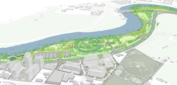
Table of Contents
- 1.1 | Purpose and Goals
- 1.2 | Master Planning Process
- 1.3 | Summary Recommendations
Part Two - Site Analysis and General Recommendations 2.1 - 2.2
- 2.1 | Park History
- 2.2 | Past Planning and Development Context
Part Two - Site Analysis and General Recommendations 2.3 - 2.4
- 2.3 | Arrival, Circulation and Parking
- 2.4 | Site Features and Built Facilities
Part Two - Site Analysis and General Recommendations 2.5 - 2.9
- 2.5 | Program Activities
- 2.6 | Visitor Experience and Wayfinding
- 2.7 | Stormwater Infrastructure
- 2.8 | Utilities Infrastructure
- 2.9 | Landscape and Vegetation
Part Three Master Plan Recommendations 3.1 - 3.2
- 3.1 | Circulation Improvements
- 3.2 | Area-Specific Recommendations
Part Three Master Plan Recommendations 3.3
- 3.3 | Building Improvements and New Facilities
Part Three Master Plan Recommendations 3.4 - 3.5
- 3.4 | Stormwater Improvements
- 3.5 | Utilities Improvements
Part Three Master Plan Recommendations 3.6 - 3.7
- 3.6 | Proposed Site Furnishings
- 3.7 | Signage and Wayfinding Improvements
Part Four - Landscape Management Plan
- 4.1 | Landscape Management Plan
Appendices
Appendix A | Topographic Survey
Appendix B | Signage Inventory
Appendix C | Operations Proposed Diagrams
Appendix D | Opinions of Probable Construction Cost
Appendix E | Meeting Notes from Public Engagement
Herter Park Master Plan Public Meetings June 10, 2021 & September 29, 2021
DCR Parkways Master Plan (2020)
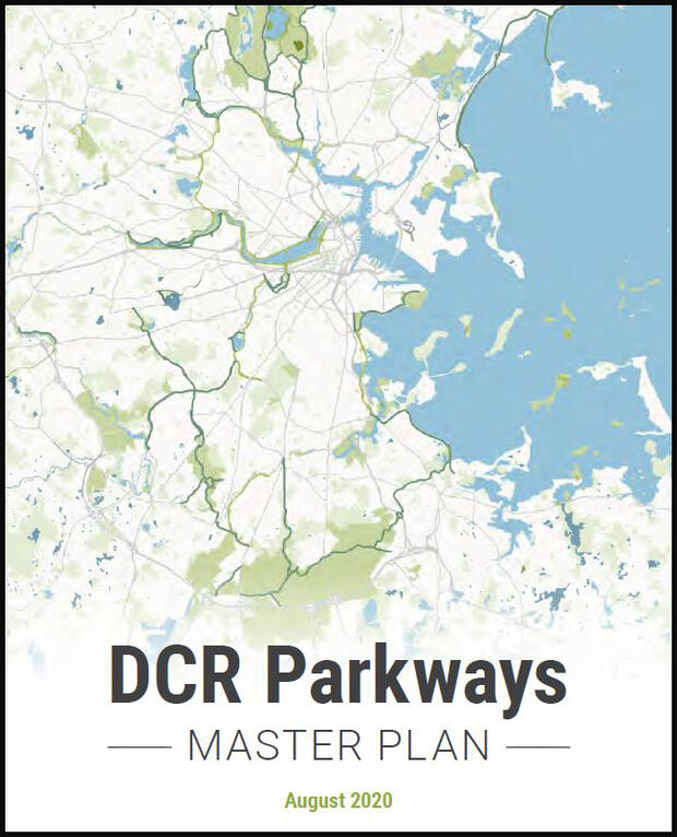
DCR Parkways Master Plan (2020)
The Plan articulates a vision for an interconnected network of walkways and bikeways throughout metro Boston that provide residents of all ages and abilities with access to recreational destinations and healthy transportation opportunities. Short-term improvements that can be rapidly implemented, long-term capital investments, and policy and design guidance for improving the parkways for all travel modes are the key features of the Plan. By realizing the vision set forth in this Plan, DCR will enhance the legacy of the parkway system by ensuring safe, comfortable access for users of all modes and all ages abilities.
New Charles River Basin Master Plan (2017)
Nantasket Beach Reservation Master Plan (2016)

The Nantasket Beach Reservation, located on the Atlantic Ocean on the northern shore of southeastern Hull, MA, is owned and operated by the DCR. The 26-acre Reservation encompasses approximately 1.3 miles of beachfront (6,800 linear feet), and includes the beach and adjacent visitor amenities, associated parking areas, and an operations and maintenance facility.
In 2005, in conjunction with a project for seawall and beach accessway repairs at Nantasket Beach, the Massachusetts Department of Conservation and Recreation (DCR) initiated this Nantasket Beach Reservation Master Plan for the landside facilities of the Reservation.
Letter from DCR Commissioner Roy - December 2016
Additional Resources
Open PDF file, 1.47 MB,
1. Introduction
(English, PDF 1.47 MB)
Open PDF file, 5.46 MB,
2. Existing Conditions
(English, PDF 5.46 MB)
Open PDF file, 494.21 KB,
3. Goals
(English, PDF 494.21 KB)
Open PDF file, 1.57 MB,
4. Related Studies
(English, PDF 1.57 MB)
Open PDF file, 1.76 MB,
5. The Plan
(English, PDF 1.76 MB)
Open PDF file, 170.01 KB,
Appendices
(English, PDF 170.01 KB)
Mystic River Master Plan (2009)
This Master Plan project was initiated by the Massachusetts Department of Conservation and Recreation to build on earlier studies and the improvements to the Reservation completed to date.
Additional Resources
Open PDF file, 6.91 MB,
Mystic River Master Plan
(English, PDF 6.91 MB)
Trailside Master Plan: Blue Hills Reservation (2008)
Cover + Contents.pdf
Executive Summary.pdf
Chapter 1- Introduction.pdf
Existing Context Plan.pdf
Chapter 2- Summary of Current Conditions.pdf
Existing Site Conditions Plan.pdf
Chapter 3- Site + Building Program and Alternatives.pdf
Chapter 4- Recommendations.pdf
Recommended Site Plan.pdf
Recommended Floor Plans.pdf
Chapter 5- Sources.pdf
Appendices
A- Architecture Appendices.pdf
B- Engineering Appendices.pdf
C- Zoological Appendices.pdf
D- Alternatives and Evaluation.pdf
E- Advisory Committee and Review Comments.pdf
F- Massachusetts Audubon Society Interpretive Plan.pdf
G- Trailside Name and Identity.pdf
Additional Resources
Neponset River Master Plan Phase II (2006)
Key Actions
Additional Resources
Alewife Master Plan (2003)
Additional Resources
Charles River Basin Master Plan (2002)
The Master Plan for the Charles River Basin is a comprehensive look at the parks, parkways, river banks, and watersheet of the Charles between the historic Charles River Dam and Watertown Square. Articulating a vision developed in partnership with the public over a two-year period, the Plan’s goal is to restore the Basin’s outstanding historic landscape character while addressing the needs of the twenty-first century. The Plan serves to guide the stewardship, the management, and the maintenance of the park land, parkways, and the water sheet. Key initiatives include preserving the historic and character-defining features of the Charles River Basin, improving the parkland and support appropriate uses, improving the river channel and manage access to the water, improving access and circulation to and throughout the Basin, and supporting management and maintenance of the Charles River Basin. The ideas and thoughtful participation of countless individuals and organizations made this Plan possible. Thanks to their continuing efforts, positive change is occurring in the Basin.
Uses and Perceptions of the Charles River Basin
Principles and Recommendations
Project Areas
John F.Kennedy Park/Longfellow Park
Soldiers Field Road/Birmingham Parkway
Greenough Boulevard, Watertown
Daly Field and the Upper Basin
Appendices
Appendix C Public Participation
Appendix D Landscape Maintenance
Key Actions
Upper Charles River Reservation Master Plan (1998)
The Upper Charles River Reservation Project addresses a 5.75 mile section of the Charles River, including 11 miles of protected river banks, from Watertown Square to Commonwealth Avenue in Newton and Weston. It is part of the agency’s larger goal to extend the Charles River greenway 14 miles to Brook Farm in West Roxbury. As this first section of the Reservation greenway is completed, it will provide a critical open-space link between the Charles River Basin and the scenic “Lakes District”, spreading over 190 acres through Newton, Weston, and Waltham.