GIS Day 2025
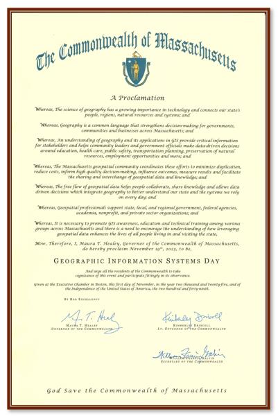
Gov. Healey proclaimed November 19, 2025, as GIS Day!
GIS Day celebrates the power of geospatial technology and is dedicated to sharing, teaching, and inspiring others with GIS. The celebration has occurred for over 25 years and has many different events.
Watch a video and learn more about GIS Day 2025.
MassGIS-CSCR Partnership
The Cohasset Center for Student Coastal Research (CSCR), a high school student-centered organization in Massachusetts that facilitates community-driven environmental scientific research of watersheds and the coast, has begun a partnership with MassGIS. Read about the partnership and CSCR's visit to MassGIS.
New MassGIS Data Hub
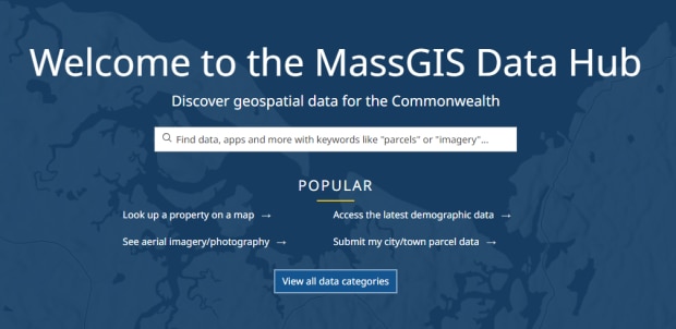
MassGIS is proud to announce the formal launch of the MassGIS Data Hub!
Our vision for this open data portal is that it will serve as a "front door" where users can go to search for public, authoritative geospatial data services from MassGIS and other organizations across the Commonwealth. Anyone can search the Hub for data of interest by entering keywords, or by browsing featured content or data categories. The Hub features options for viewing the items in maps and downloading the data in several formats.
The site searches MassGIS's ArcGIS Online organization for map, feature, image, and tile services, along with web maps, applications, and dashboards. We've also added items from the Executive Office of Energy and Environmental Affairs and MassDOT.
We’d like to include your data too!
To make the Hub as useful as possible to the GIS user community, we extend an invitation to any organizations that would like their ArcGIS Online-based authoritative data to be discoverable in the MassGIS Data Hub. For us to consider your data for inclusion, you would need to create an ArcGIS Online Open Data group and publicly share it with Everyone. Include metadata and plenty of good keywords on the item details pages of your services for best results. Then, send Michael Trust the name of the group and he will review it. If included, users who search our Hub will be able to find your ArcGIS Online data and apps. Also, if you want our items discoverable in your Hubs, email Michael for the groups you would need to add to your Groups Manager.
Massachusetts Geospatial Strategy
Learn more about this initiative to help guide our activities through the end of the decade.
New 4/15/2024: Read the workshop summary documentation.
Maps and apps
New Massachusetts Municipal GIS Gallery
- Search for a city or town name to find its online GIS maps and applications. If a city or town does not have its own app, MassGIS has created a "MuniMapper" -- a customized version of MassMapper for a municipality.
Updated version of our Statewide Wall Map

- Download this free PDF (34MB, page size is 42x33 inches). The layout has been updated with several "fun facts" about Massachusetts and a map showing percent population change by municipality from 2010 to 2020.
The main map displays standard basemap features (city and town and county boundaries, major roads and highways, major lakes and rivers, areas of permanently protected open space, watershed boundaries, hillshade, and other points of interest). Also included is an index to municipalities and an inset map featuring MBTA Rapid Transit and Commuter Rail lines and stops in the Greater Boston area.
Sexual Assault, Domestic Violence, and Human Trafficking Resource Viewer: View resources across MA for survivors of sexual assault, domestic violence and human trafficking.
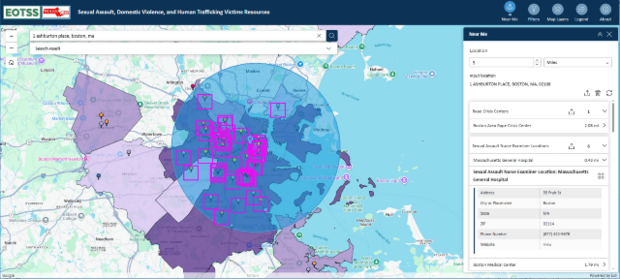
- This web app, created by MassGIS for the Governor’s Council to Address Sexual Assault and Domestic Violence, contains housing support, rape crisis centers, hospitals with a Sexual Assault Nurse Examiner (SANE) program, and District Attorney's offices. It also contains the Filter and Near Me widgets to help survivors find facilities relevant to them. (Updated 11/6/2025)
Statewide Property Sales Viewer: View property sales from the past fiscal year across the state
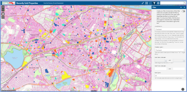
- The Statewide Property Sales Viewer maps real estate sales assembled by the State's Bureau of Local Assessment (part of the Division of Local Services). The source is the annual "LA3" sales reports provided by municipal assessors. On the Division of Local Services website, these sales can be searched by property type, range of sale date or price, and other characteristics. You can download the search results. This MassGIS sales viewer application supports the same search criteria and then maps the result, color coding the sales based on their assessment-to-sale ratio. You can also still see and download the tabular result.
MassGIS Imagery Time Series: 30 years of Massachusetts orthophotos
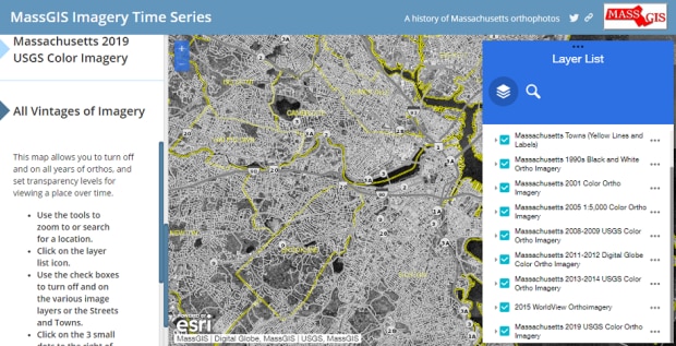
- This app explains our ortho imagery acquisitions through the years and allows you to explore the various vintages in one location, from the black and white imagery of the 1990s to the 2019 high-resolution color imagery program.
News
July 17, 2025 - MassMapper interactive mapping application has been updated with significant enhancements.
October 2, 2024 - MassGIS staff attended the MAAO Conference on Oct. 2, 2024, and made two presentations on standardized parcel mapping. These PowerPoint files contain animations and are best viewed in slideshow mode. Many of the slides also contain notes.
- Utility & Importance of Parcels & Assessor Records In MassGIS Projects (92.5 MB)
- Maintaining Standardized Parcel Mapping: QA Process for Assessors (10.6 MB)
August 23, 2024 - Executive Office of Technology Services and Security, UMass Amherst to Partner on Geographic Information Hub for Western Mass. See the press release.
GISette Newsletter
The "GISette" is MassGIS' Newsletter. It features news, data updates, event information, and more.
Read our latest GISette and sign up to receive them by email.
Data updates
- Property Tax Parcels
January 29, 2026 - 16 municipalities: Belchertown, Boylston, Dighton, Dracut, Fall River, Lunenburg, Marion, Northborough, Raynham, Reading, Salem, Shrewsbury, Springfield, Upton, Waltham, and Westport. - Building Structures
January 26, 2026 - Updated with edits compiled atop MassGIS' spring 2025 imagery for portions of Cape Cod. - Public Utility Service Providers
January 14, 2025 - Update based on data from the Massachusetts Department of Public Utilities from October 2025 and the Massachusetts Department of Telecommunications and Cable from January 2026. - Schools (Pre-K through High School)
December 19, 2025 - Update based on the Massachusetts Department of Elementary and Secondary Education (DESE) school profiles database as of November 5, 2025. - MHC Historic Inventory
December 10, 2025 - Massachusetts Historical Commission staff have completed a significant update to the towns of Boston, Eastham, Fall River, Lincoln, Marblehead, Mattapoisett, Medford, Monson, Nantucket, Swampscott, Watertown, Wellfleet, Westminster, Winchester, and Whitman, reviewed and corrected data for some of the first towns to be digitized: Blackstone and Mattapoisett, and updates are in progress for Andover, Attleboro, Bridgewater, Middleborough, New Bedford, and Westport. - MassDEP Estimated Sewer System Service Area Boundaries
December 16, 2025 - Updates to this dataset that represents approximate service areas for sewer systems operated by publicly owned treatment works (POTWs), sewer districts and non-POTW systems. - Protected and Recreational Open Space
November 6, 2025 - Energy and Environmental Affairs GIS staff have updated the Protected and Recreational OpenSpace layers (arcs and polygons), available from MassGIS. Since the last publication to the web, staff at EEA and its associated agencies performed edits that improved the boundaries and/or descriptive geography to over 3,900 polygons in 160 municipalities,resulting in a net gain of over 6,600 acres.
Shapefile and file geodatabase downloads represent data updated as of 10/14/2025.
The details:- Added or improved the boundaries and attributes of many types of recreational areas and open spaces with various levels of protection: 134 conservation areas, 17 water supply lands (both state and local)/watershed restrictions, 30 agricultural preservation restrictions (all types)/community gardens, 66 parks/beaches/rail trails and 55 conservation restrictions/easements.
- EEA additionally updated the database with numerous EEA-sponsored programs: 2 Conservation Land Tax Credits, 13 Parkland Acquisitions and Renovations for Communities (PARC) grants, 6 Landscape Partnership grants, 1 Forest Reserve grant, 8 Conservation Partnership grants, 4 Cranberry Bog Acquisition for Restoration grants, 2 Drinking Water Supply Protection grants and 3 Local Acquisitions for Natural Diversity (LAND) grants.
- Trains
October 31, 2025 - Updated the MBTA Commuter Rail point and line data to reflect the opening of the South Coast Rail route and made other spatial and attribute edits. - National Wetlands Inventory
September 23, 2025 - New data from the U.S. Fish & Wildlife Service as of 5/7/2025. - RMV Locations
September 22, 2025 - MassGIS moved the point for the Braintree Service Center to its new location.
July 14, 2025 - MassGIS moved the point for the Revere Service Center to its new location in Chelsea.
June 23, 2025 - MassGIS moved the point for the Milford Service Center to its new location. - MassDEP data layers
September 15, 2025 - Updates to the Public Water Supply Sources and Wellhead Protection Areas (Zone II, Zone I, IWPA) data, current as of 9/3/2025. - MassDEP data layers
August 28, 2025 - Updates to the Groundwater Discharge Permits data, current as of 8/27/2025, MassDEP Tier Classified Oil and/or Hazardous Material Sites (MGL c. 21E), and MassDEP Oil and/or Hazardous Material Sites with Activity and Use Limitations (AUL) data, current as of 8/26/2025. - Ice Rinks
August 11, 2025 - Extensive update and overhaul of the ice rinks dataset - Office of Fishing and Boating Access Sites
July 29, 2025 - Latest update from the Massachusetts Department of Fish and Game.
May 20, 2024 - Attribute table modified. - FEMA National Flood Hazard Layer
July 25, 2025 - The latest update includes data published by FEMA as of July 18, 2025 (Latest Study Effective Date = 7/8/2025; Latest LOMR Effective Date = 7/9/2025). - MassDEP data layers
June 27, 2025 - New datalayer Designated Densely Developed Areas sent to MassGIS by MassDEP. - Libraries
April 9, 2025 - Extensive update of the datalayer with locations of public (and some special) libraries across the Commonwealth sourced from the Massachusetts Board of Library Commissioners and the Massachusetts Library System. - MassDEP Eelgrass
March 11, 2025 - With this update, Phase 6 of the mapping project is complete, adding features from imagery collected in 2022 (Marshfield to Gloucester) and 2023 (Rockport through Newburyport). Both sections were interpreted and delineated in 2023. - Designated Shellfish Growing Areas
February 21, 2025 - Revision of some boundaries. The June 2024 update was the first to the layer since 2017. - Community Health Centers
February 20, 2025 - Extensive update of the datalayer with locations of Community Health Centers across the Commonwealth sourced from the Massachusetts League of Community Health Centers. - Community Behavioral Health Centers
February 19, 2025 - New datalayer with locations of Community Behavioral Health Centers across the Commonwealth from the Executive Office of Health and Human Services and their Find a CBHC tool. - MassDEP Solid Waste Diversion and Disposal
February 14, 2025 - New and revised data. ArcGIS Services now available. - DCR Pools
January 28, 2025 - Layer updated based on current locations list from the DCR website. - MassGIS-MassDOT Roads
January 16, 2025 - Update of major intersection near Hanscom Air Force Base and reassignment of State Route 1A near Logan Airport.
October 8, 2024 - This update includes a thorough review, with thousands of features added or modified. - 2021 Legislative Boundaries Updated
January 10, 2025 - Polygon attributes were updated to reflect recent member changes to these layers: - Places of Worship
January 3, 2025 - Extensive data layer update confirming, removing, and adding new locations of churches, synagogues, and mosques across Massachusetts from a variety of sources. - Licensed Child Care Programs
December 13, 2024 - New datalayer with locations of licensed child care programs based on a list sent by the Department of Early Education and Care (EEC). - Massachusetts Community Lookup Table
December 11, 2024 - Maintenance Update: Based on feedback from the Martha's Vineyard Commission (MVC), MassGIS added "Elizabeth Islands" for Gosnold (TOWN_ID = 109), "Nomans Land" for Chilmark (62), "Chappy" for Edgartown (89), changed the source of "Vineyard Haven" for Tisbury (296) to ZIP, and changed the source of "Vineyard Haven" for Oak Bluffs (221) to MVC. - MassWildlife Inland Water Bathymetry
December 2, 2024 - MassWildlife GIS staff added linework for 104 more water bodies and created a new imagery dataset. - Massachusetts Community Lookup Table
November 22, 2024 - Lookup table providing an up-to-date list of alternate town names, both historic and contemporary, used by residents to refer to their neighborhood, section, mailing address, etc., for all 351 municipalities in the Commonwealth of Massachusetts. - MassDEP Water Utility Resilience Program Mapping Project
October 1, 2024 - The datalayers depict areas served by public water systems (PWSs), including community or non-transient non-community PWSs. This work is being completed as part of the Massachusetts Department of Environmental Protection’s continued work in Enhancing Resilience and Emergency Preparedness of Water Utilities Through Improved Mapping. - Acute Care Hospitals
September 26, 2024 - Points for Steward Carney Hospital and Nashoba Valley Medical Center were removed following their closure on August 31, 2024. - Prisons
July 26, 2024 - MCI - Concord was removed following its closure in July 2024. - Acute Care Hospitals and Non-acute Care Hospitals
July 3, 2024 - Extensive update based on data sent from the Mass. Department of Public Health (DPH) and the Center for Health Information and Analysis (CHIA) in November 2023. - NHESP Natural Communities
July 2, 2024 - Latest update from NHESP, from the 2020 edition of the Classification of Natural Communities of Massachusetts. - 2020 Environmental Justice Populations
June 6, 2024 - EEA GIS made one minor update to fix a block group in Lowell that was misidentified as being in Chelmsford. - Massachusetts House Legislative Districts (2021)
June 3, 2024 - Attribute table modified due to a special election in the 6th Worcester District. - 2023 Aerial Imagery
May 16, 2024 - The latest statewide color aerial imagery from MassGIS. Appears as a basemap option in MassMapper and ArcGIS Online apps. - Municipalities (Cities/Towns)
May 6, 2024 - Modified attribute tables, including adding population fields for 1960, 1970, 2020, and a 2010-2020 population change field. Removed older population change fields. - MassDEP Major Facilities
March 29, 2024 - MassDEP has an updated release of Major Facilities data. - Non-Potential Drinking Water Source Areas
March 29, 2024 - MassDEP added one polygon and expanded another in Agawam. - ZIP Codes (5-Digit) from HERE (Navteq)
March 25, 2024 - MassGIS modified the boundaries for all ZIP Code areas in Boston based on the U.S. Postal Service's ZIP Code Look Up by Address website. MassGIS also added polygons for ZIP Codes 02199 and 02203. - MOTT Regions
March 6, 2024 - Two new data layers developed from maps sent by the Massachusetts Office of Travel and Tourism: - Colleges and Universities
March 5, 2024 - Extensive update based on data downloaded from the National Center for Education Statistics (as of November 21, 2023) and data sent by the Massachusetts Office of Consumer Affairs and Business Regulation Division of Professional Licensure (last updated in August 2023). - Long Term Care Residences
March 1, 2024 - Extensive update based on data sent by the Massachusetts Department of Public Health (MDPH) and Massachusetts Executive Office of Elder Affairs as of Winter 2024. - MassDEP Water Quality Monitoring Stations
February 29, 2024 - The categories of features include updates through 2022. - Bedrock Altitude and Overburden Thickness and NEHRP Soil Classifications
February 6, 2024 - This new set of data layers was part of the Massachusetts Depth to Bedrock Project, performed by the Mass. Geological Survey, Dept. of Earth, Geographic and Climate Science, UMass Amherst, and sponsored by the MassDOT Office of Transportation Planning. - Hiking Trails for NextGen 911
November 14, 2023 - This data layer of trails across Massachusetts contains mostly those found in wilderness areas and used for hiking and was developed to assist telecommunicators with lost hikers and potentially respond to emergencies in remote areas. First published in January 2023, the layer was recently updated with tens of thousands of lines sourced from OpenStreetMap. - 2022 Wards and Precincts
November 7, 2023 - Updated to merge the area of subprecinct 3A in precinct 3 in Groton into precinct 1 based on a legislative change. - Subprecincts (2022)
November 3, 2023 - Subprecincts represent areas within individual precincts that have been assigned to a State and/or Congressional voting district that is different than those assigned to other areas within that same precinct. - Geographic Place Names
October 13, 2023 - Updated the Hypso feature classes to remove a label off Cape Cod. - Community Preservation Act (CPA) Projects
August 15, 2023 - New shapefile available for download reflecting the current status. - Farmers' Markets
July 26, 2023 - The Department of Agricultural Resources has provided an update to the statewide Farmers' Markets. The data lists locations, hours of operation, EBT inclusion and many other fields. - Bicycle Trails
June 22, 2023 - This data set replaces the 2004 layer of bicycle facilities in Massachusetts. It consists of four facility types: shared use paths, bike lanes, separated bike lanes and bicycle/pedestrian priority roadways. The inventory is primarily from MassDOT's 2020 dataset and includes all state-owned infrastructure as well as facilities under local jurisdiction. Linework has been adjusted in some places to be more accurate based on DCR Trails, Open Street Map, and MassGIS 2021 Orthoimagery. - MassDEP data layers
May 5, 2023 - Surface Water Supply Watersheds and Surface Water Supply Protection Areas (Zone A, B, C). - Massachusetts Geographic Response Strategies
April 21, 2023 - New layers from MassDEP. A Geographic Response Strategy (GRS) is a planning document and response tool intended to guide local responders during the first 24 to 48 hours of a major coastal oil spill until professional contracted oil spill response personnel and additional resources supplied by Unified Command can arrive. These replace the Geographic Response Plan (GRP) data from MassDEP. - Massachusetts Commission for the Blind (MCB) Regions
April 11, 2023 - The MCB has 6 regions composed of groupings of municipalities. MassGIS has created this regions layer with contact information for each region. - Limited Access Highway Exits and Interchanges
March 27, 2023 - New and revised data representing off-ramps and junctions on limited access highways, based on data from MassDOT. - MassDEP Mouth of River (MOR) Lines
February 2, 2023 - This new data layer contains the Mouth of River (MOR) lines for Massachusetts coastal rivers originally published by the Massachusetts Department of Environmental Protection (MassDEP) on March 1, 2005, as PDF maps. - Diadromous Fish
February 2, 2023 - Five new data layers of diadromous fish passageways, impediments, habitat, species presence and sampling stations along coastal rivers and in lakes and ponds. Diadromous fish species travel between salt water and fresh water as part of their life cycle. - Community Preservation Act (CPA) Towns
January 18, 2023 - MassGIS updated the status of several towns to reflect recent elections that approved the adoption of the CPA. A new layer file that shows year of adoption is now included in the download. - 2021 Legislative and Administrative Boundaries
January 13, 2023 - These district boundaries for Massachusetts, signed into law in November 2021, now have member names populated with the results of the November 2022 election, and revised coastlines to match the 2020 Census data: